Archaeological Investigations at Sandwich Castle

ARCHAEOLOGICAL INVESTIGATIONS AT SANDWICH CASTLE I. J. STEW ART with contributions from M. L. Herdman, J. Iveson and K. Parfitt 
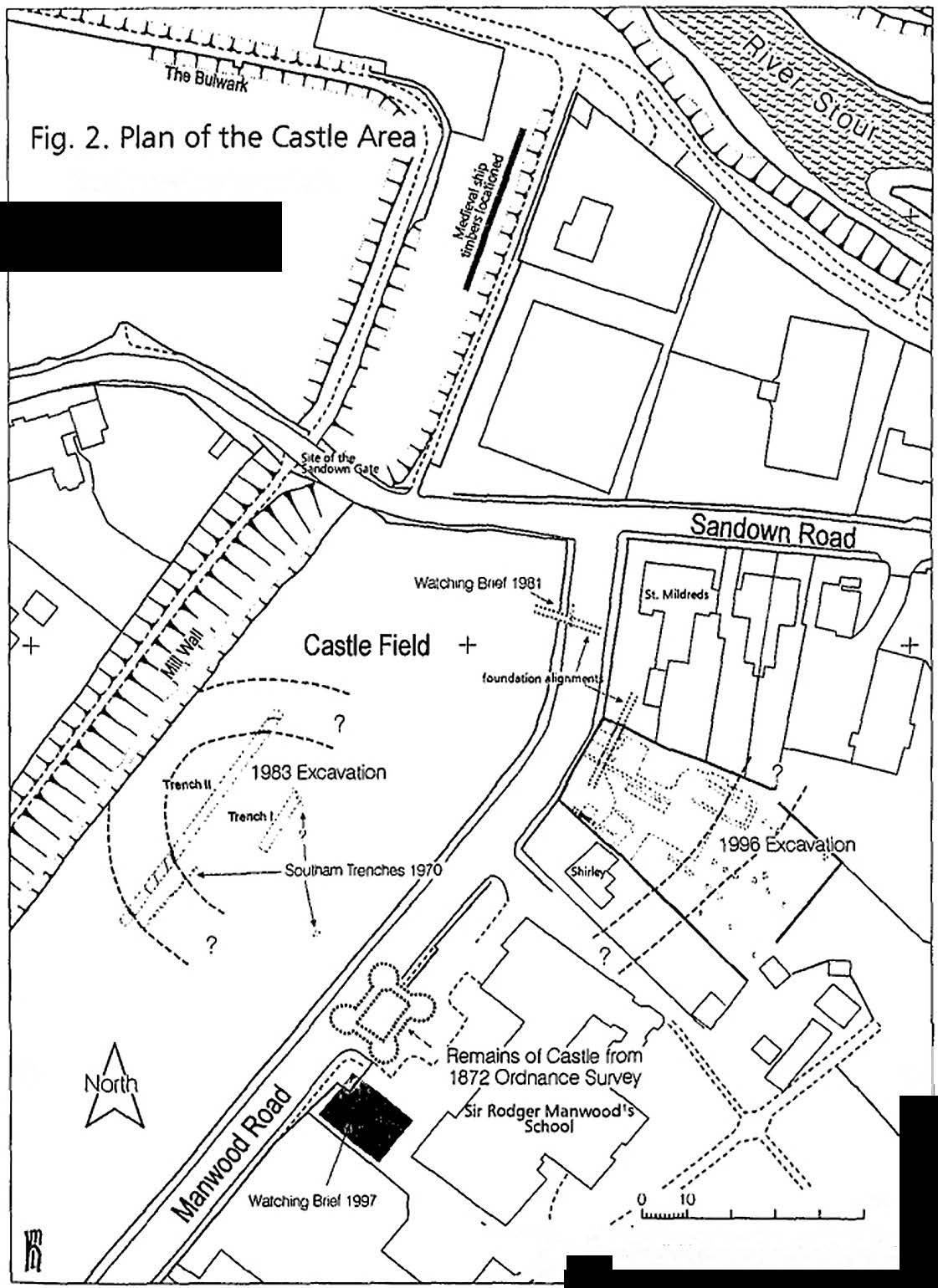
The historic Cinque Port of Sandwich (Fig. 1), with its ancient buildings, defences and quay on the River Stour, is known from records to have once had a castle, but today it lacks any obvious remains of such 0 100 ftep,oc:h.1ctd from Ordn.)nce Survey material with the permjssi0n of The Controller of l-ler Ma;esty's Statione􀁡ry Office, C Crown Ccpyr;ght lltenDeal Fig. I. Map of Sandwich with Site Location. 51 I. J. STEWART a structure. The original Anglo-Saxon town was established on a piece of ground isolated on three sides by marsh and water, with only a single broad causeway providing access from the south. To the north lay a beach, upon which boats could be drawn, and beyond it the Wants um Channel, with an anchorage sheltered by the Isle of Thanet. The early settlement grew into a major trading port (Parkin 1985, 191) but it does not appear to have received any defences following the Norman Conquest - the main strategic castles of the area being placed at Dover, Canterbury and Rochester. Sandwich with its large anchorage, however, was an ideal landing point. It received several Scandinavian attacks during the eleventh century and two destructive ones by the French (in 1217 and 1457). Despite these setbacks, the port flourished throughout the medieval period. Low-lying marshland around the town was reclaimed from the twelfth century onwards, making possible new routes out of the town. However, natural deposition moved the shore-line eastward and the anchorage shrank as the Wantsum slowly silted up. This gradual enclosure eventually led to a decline. By the sixteenth century the harbour had become too restricted to allow the passage of large ships. Early town defences, constructed during the Baron's War, were destroyed in 1275 as punishment for their use in keeping out a Royal Commission; but the town was re-defended in the middle of the Hundred Years War (Gardiner 1954, 35 & 12 I) and the remains of these defences survive today, along with some later additions. A masonry wall overlooked the harbour, and around the rest of the circuit there was a bank and ditch with masonry gates - though most of these gates have since been removed to improve access. Just outside the defences, close by the site of the Sandown Gate, lies Castle Field (Figs 1 and 2). This location is traditionally regarded as the site of the town's castle. In the field is a low mound bounded by a depression on one side. The site has been examined by excavation on two occasions which proved the presence of defensive works here. Documentary evidence indicates that some remains of an associated stone building had survived nearby until the later nineteenth century. The proposed development of a plot of land on the eastern side of the adjacent Manwood Road was sufficiently close to the area of Sandwich Castle to lead the County Archaeologist to request an archaeological field assessment on the plot. Accordingly, in 1995 the Canterbury Archaeological Trust (CAT) was invited to cut a single evaluation trench across the area. This located the top of a levelled rampart but failed to provide a clear picture of the remains present. In June 1996, following the stripping of the top-soil ahead of the 52 + + ARCHAEOLOGICAL INVESTIGATIONS AT SANDWICH CASTLE Showing location of excavations Reconsuucted ditch lines combining excavation and topographical information " I " 􀀄 + S•'Jm • • • • ",,'" .... . l'leprod\Ktd f,om Ordo.tnc:e Sotvey ma􀀦ial IMl:h the -<'􀀇,"" 􀀏􀀐:.,:c􀀑;;Ytt􀀒!􀀓 􀀔􀀕IYa&t\·􀀖􀀗1 Fig. 2. Plan of the Castle Area showing location of excavations. new building work, a watching brief was maintained by the writer on behalf of CAT. This revealed that the archaeological remains on the site were rather more extensive than originally suspected. Under the 53 l. J. STEWART direction of the writer, assisted by Keith Parfitt, a series of hand-dug trenches were excavated to further investigate the exposed remains. This work was conducted at weekends, mainly by volunteers from the Dover and Lower Medway Archaeological Groups. SUMMARY OF PREVIOUS ARCHAEOLOGICAL WORK IN THE SANDWICH CASTLE AREA (FIG. 2) 1872 Ruined building marked 'The King· s Castle' appears on the I :2500 O.S. map. 1881-2 Last remains of the castle building were broken up and removed. Extract from the Deal Telegram, 22 January, 1881 :- The foundation, which is all that has remained for a long time of this very ancient building, is now being with great difficulty, broken up and removed. As it exists principally of solid masonry and concrete as hard as the stone, great force is necessary and but slow progress is made. In the year 147 I the followers of the bastard Fauconberg, upwards of 800 in number. strongly fortified themselves in the Castle, but upon the King's approach to attack them they submitted and delivered up the Castle, and also thirteen ships in the harbour. Fauconberg was afterwards executed at Southampton. The removal of the foundation of the Castle is been carried out for agricultural purposes. 1886 Buried foundations still showed as parch marks (Scott Robertson 1886). 1970 Field work in Castle Field by G. H. Fretton, C. Burch and D. Harle, close to Man wood Road, located extensive demolition material near the destroyed castle building. 1970 Excavation by Sandwich Archaeological Group, led by the late Alfred Southam, across the mound in Castle Field. Three trenches were dug. One located a very large ditch which appeared to have the remains of a bank or mound on the north. No account of this work was published and few records now appear to survive, apart form a section drawing. This excavation has been largely superseded by work in 1983. 1981 Watching brief by the Dover Archaeological Group on a gas pipe in Manwood Road located a substantial wall foundation (see below). 1983 Excavations by CAT at the mound in Castle Field. The ditch found in 1970 was fully sectioned - it was 14.25m wide by 4.5m deep. A second ditch that may be as large was located 54 ARCHAEOLOGICAL INVESTIGATIONS AT SANDWICH CASTLE 35.5m away; between them lay the upcast, apparently forming the base of a mound. Under the mound were a series of earlier deposits including one cut by numerous post- and stake-holes and a hearth. These features were covered by a layer containing pottery and other occupation debris of late twelfth century date. This layer has been interpreted as a buried top-soil formed prior to the deposition of the castle mound (Bennett, Blockley and Tatton Brown 1984 ). 1993-4 CAT watching brief on the site of a new science block at Sir Rodger Manwood's School. (NGR TR 3348 5781). No medieval features were located (CAT archive report by M. L. Herdman). 1995 CAT evaluation excavation on land adjacent to Shirley, Manwood Road, ahead of a new development (CAT archive report by M. L. Herdman). Further work was undertaken in 1996. 1996 CAT watching brief followed by excavation on the land evaluated in 1995. (CAT archive report by I. J. Stewart and M. L. Herdman) The results of this work are detailed below. 1997 CAT watching brief during the construction of new classrooms at Sir Rodger Manwood's School (NGR TR 3347 5789). No significant archaeology was found (CAT archive report). DOCUMENTARY EVIDENCE by Jon Iveson A number of references to fortifications at Sandwich occur during the thirteenth century, but these seem to concern temporary structures such as the 'brattices' (temporary wooden towers) erected by Roger of Leybourne in 1266. However a reference in 1275 to the removal of barbicans and other fortifications raised during the rebellion of the previous year, and to the filling of the trenches around the town, might indicate more substantial fortifications. The first certain record of a castle at Sandwich occurs in the accounts of 1297/8 when Adam of Lyminge received £20 from Sir John de Berwick, Keeper of Queen Eleanor's wardrobe, for 'works' at Sandwich. Adam ofLyminge had been appointed as King's Bailiff in 1290, when the crown regained control of the town from Christ Church Priory. Throughout 1297 the bailiff acted as keeper of the 'tower', town and port and drew wages of £12 p.a. The tower later became known as the castle and remained the headquarters of the bailiff until the office was absorbed by the Corporation. 55 I. J. STEWART On the appointment of a new bailiff in 1299 the king's mandate ordered that the tower, town and port together with the armour and all other things in the tower, town and port be handed over to Hugh Helpeston, who had been appointed to the office. In 1303 the king appointed John of Hoo as viewer of the King's house and tower in association with Thomas de Shelving, and the account for 1304/5 indicates that repairs were made to it. In 1361 the first reference to the strengthening of the castle appears. Twelve carpenters are instructed by the sheriff to go to Sandwich and work on the king's works without delay. The first reference to the castle as a gaol also occurs, and it seems that the verger, who was custodian of the castle acted as gaoler. The fear of French raids in 1384/5 caused the castle to be garrisoned with 12 men at arms and I 2 archers and was probably the reason the castle was extensively repaired in 1386. These repairs were supervised by Thomas More, who was appointed verger and custodian of the castle in November, although his predecessor, Kent, had begun the work in June. At the end of the month he had an order for taking masons, carpenters and workmen for 'works at the castle', and special mention was made of the purchase of stone, timber and lime. Four carpenters repaired the drawbridge, four sawyers were busy cutting up timber, two workmen were engaged on the walls for a month, while labourers were occupied on ditching and building. Later six carpenters were at work for four days, and forty labourers were engaged for one day in the ditch and on the foundations. The drawbridge at the entrance was rebuilt, four timber rails, a great rope of 12 strands and four hundred great nai Is were used for it. Timber, keys, three great locks with six keys and hinges were found for the gate, and the turrets and the gutters were repaired by Thomas the Plumber. The work was still going on the following summer. Twelve men at arms and twelve archers remained as the garrison. Rye and Dover were being fortified at the same time, and Simon de Burley was ordered to fortify the town of Sandwich. These works sound rather more than the repairs which the accounts indicate. In 1404 John of Whitney, verger and keeper of the castle, received lances, poleaxes, crossbows, sheaves of arrows and two stone guns with their stocks and gunpowder, for the defence of the castle and town. In 1440 references to masons working with carpenters and workmen in the castle indicate that further building work was under way. Accounts of a French raid by Pierre de Breze in August 1457 and the capture of the town make no reference to the castle, but illustrations in Vigiles de Charles Vil seem to show an assault on a tower 56 ARCHAEOLOGICAL INVE STIGATIONS AT SANDWICH CASTLE with four corner turrets and a drawbridge as well as an assault on the town itself. The castle seems to have survived the raid and no accounts of repairs appear in the period immediately afterwards. In 1471 Lord Fauconberg retreated to Sandwich and seized the castle with the support of eight to nine hundred men, before escaping from Britain. The last medieval reference to the castle is in 1483, when a list of stores and ordnance shows that it contained 'l great gun with 3 chambers' and '3 serpentine guns with 6 chambers'. Whilst it is likely that the building by Henry VIII of the castles to protect the Downs caused Sandwich castle to be demolished for building materials, it is also possible that the building of Dover harbour in 1536 saw the destruction of the castle. EXCAVATIONS AT MANWOOD ROAD by I. J. Stewart, M. L. Herdman and K. Parfitt Located some 80m outside the eastern defences of the medieval walled town, opposite Castle Field, the site investigated in 1996 (NGR TR 3355 5796) occupied an open plot of ground fronting onto the south-eastern side of Manwood Road (first laid-out during the early twentieth century), between Shirley and St Mildreds. The plot was almost rectangular in shape and measured some 65m in length (NW-SE) by 22-35m in width (NE-SW). It is now occupied by Sandate House and its gardens (Fig. 2). The site stands at about Sm above OD, upon a low promontory of Thanet Beds (Foster 1998), which protrudes into the marshland of the southern flood plain of the River Stour, north of the Lydden Valley (formerly part of the Wantsum Channel). Due to its low elevation the subsoil on the site is permanently waterlogged and during the winter months the water-table can rise to within a metre of the surface. Following machine clearance of the top-soil across the northwestern half of the site in the summer of I 996, a series of twelve trenches (Trenches 1-12) and eleven test pits (Test Pits I-Xl) were excavated by hand across the area in order to investigate a series of archaeological features and deposits which had been exposed by the initial clearance work (Fig. 3). This succeeded in identifying the presence of a major ditch and the base of an associated earthen rampart. Beyond the ditch, at the south-eastern end of the site, there appeared to be little of interest and test-pits here revealed natural Thanet Beds at a depth of a metre or less. At the north-western end, however, adjacent to Manwood Road, a more complex sequence of archaeological deposits and building remains was revealed. These 57 ······•················ _, l..-d11\ I I N􀀂 '··''- , ... fp XI J"'"·"I'. 􀀊Ill [j 'tP II Test Pits 1 - xr r;,_ _-: . f'! 􀀂, 'tPVII 'tPX 0 5 10 20 30m Fig. 3. Manwood Road site plan showing trenches and larger features. ARCHAEOLOGICAL INVESTIGATIONS AT SANDWICH CASTLE appeared to be of medieval date and there seems little doubt that they relate to a hitherto unknown part of Sandwich Castle. A large ditch or moat backed by a clay rampart was located running across the central part of the site and there appears little reason to doubt that these major features relate to the outer defences of the castle. They lie considerably further to the east than the remains located in Castle Field and suggest that the castle at Sandwich may have covered a substantially larger area than has been previously supposed. The Probable Ditch or Moat Trenching close to the centre of the plot, where there was some surface evidence for a very slight depression, revealed the presence of a large negative feature running for a distance of at least 22m across the site. This appeared to be aligned north-east by south-west and was between I 0.50 and 14m in width, with sloping, somewhat ill-defined sides. Excavation was largely confined to defining the upper edges of this feature but it seems fairly clear that it represents a section of a very large in-filled ditch or moat, extending beyond the boundary of the site in both directions (a depression visible in the garden to the south-west must represent its continuation here). Six trenches and two of the test-pits excavated cut the deposits in-filling the ditch [Trenches 6, 7, 9, JO, 11, 12; Pits V & YI]. The deepest, at over 2m, was Trench 9, machined-out by the building contractors. The upper filling of the ditch consisted mainly of a mottled blue-grey clay which was over 0.80m in thickness. No finds were recovered from this deposit, which may well represent deliberate back-filling. The natural water-table was encountered towards the base of the deepest trenches and a strong sulphurous smell, indicative of waterlogged conditions below, was present. No attempt was made to ascertain the full depth of the ditch, which was clearly substantial. Significant organic remains may well be preserved within its untouched lower fills. A complete section cut across the outer ditch in Castle Field showed it to be some 14.25111 wide and 4.50m deep, and comparable dimensions for the present feature seem likely. Due to its low-lying position, drainage ditches and dykes are a regular feature of the landscape in and around Sandwich, but there is no evidence of the present ditch on any nineteenth-century maps of the area, implying that by then it served no useful purpose as a major land drain. However, three sets of post-medieval field drains, one of wood and two unglazed ceramic, had been inserted at various times along the centre of the in-filled ditch. 59 I. J. STEWART The Rampart Base (2] Before excavation began, a faint ridge was visible on the surface, running south-west by north-east across the central part of the site, immediately to the north-west of the depression which excavation subsequently showed to be the top of a ditch (see above). The ridge could also be seen to continue into the back garden of the adjacent house to the south-west (Shirley), where it has been somewhat modified to form a garden terrace. No traces beyond Shirley, within the grounds of Sir Rodger Man wood's School were visible, however; nor had anything survived in the gardens to the north-east of the excavated area. On site, removal of the thin layer of top-soil revealed that the ridge was formed by an extensive deposit of mottled yellow-green silty clay with occasional flints, charcoal flecking and small patches of red oxidised clay [2]. Initially appearing to represent the virgin sub-soil, an exploratory trench soon revealed that this clay was a dump of re-deposited natural material that sealed a thick earlier layer of sandy clay, containing a sherd of undiagnostic medieval pottery. Although poorly preserved along the north-eastern margin, the clay dump itself extended across the full width of the plot and varied between 7 and 17m across. It was up to 0.80m thick at the centre but had somewhat ill-defined edges. Situated immediately to the north-west of, and parallel to, the large ditch which crossed the site and quite probably derived from its excavation, this extensive dump of clay may be readily identified as the base of a substantial earthen rampart, seemingly without any associated revetment wall, either of timber or stone. Although still surviving as a slight surface earthwork, it seems clear that much of this rampart had been removed over the centuries, probably deliberately levelled. The most obvious place to push such an unwanted rampart would have been into the adjacent ditch, the upper filling of which consisted of a mottled clay that could be deliberate back-fill. The rampart dump produced a total of eight pot-sherds, all dated c. 1150/75-1200. This material is likely to be residual but shows that the rampart could not have erected before the start of the thirteenth century. Internal structures Accepting that the low ridge of dumped clay does represent the base of a rampart, with a large outer ditch beyond, it seems most probable that a series of structures, features and deposits located on the 60 ARCHAEOLOGICAL INVESTIGATIONS AT SANDWICH CASTLE 0 5 10 20m No􀀃 Fig. 4. Plan of North-West end of Manwood Road site. north-western side of the excavated site relate to buildings set within the enclosed area in the Jee of these defences (Fig. 4 ). Although a precise stratigraphic sequence cannot be produced, it seems clear that the various features located are not all of the same date. Early remains, perhaps roughly contemporary, seem to include two wall foundations [9 & 28] and a gully located running along the tail of the rampart [34]. An extensive spread of rubble [6] forming a rough surface across most of Trenches I and 2 seems to be later, whilst the spread of roof tile in Trench S [ 18] is later still, probably post-medieval. These features are described in detail below. The Broad Foundation [9] A substantial flint foundation [9] was examined in Trenches I, 3 and 4. It was aligned north-east by south-west, parallel to Manwood Road and was traced for a total distance of about I Sm, ending before it reached Trench 8 on the south-western edge of the site. The found- 61 I. J. STEWART North West South East • machined horiZon ----------------©------------------- .. 0 1 ' I I I I I ] ] ) I CUI 12 ® 2m I surtace? ·6 Section 1 Trench 1 North East South West Section 2 Trench 8 Fig. 5. Sections I and 2 (Trenches I and 8 re spectively). ation was between 1.40 and 1.60m wide and was constructed from alternate layers of flint pebbles and cobbles, set in clay [9]. Where sectioned in Trench I, it was found to be some 0.55m thick (Figs 5 & 6). The trench for the foundation was cut through a layer of compact brown sandy soil [15] that had developed over the natural clay. The associated wall above the foundation had been completely removed but was marked by a shallow robber-trench. A thin deposit of mortar [35] resting on the surface of soil layer [ 15] and extending from the north-western side of the foundation must represent the wall construction layer. Patches of white mortar, also connected with the construction of the wall, lay along both margins of the foundation surface and had subsequently been cut through by the robber trench. From their position it may be suggested that the robbed wall had been roughly 1.20m in width, which implies that it related to a substantial masonry building. No obvious floors or occupation layers associated with this building had survived [6]. Another section of foundation of similar size and construction has been previously recorded on the western side of Manwood Road, but this probably formed part of another structure (see below). The soil layer [ 15] cut by the foundation trench produced some thirteen pot-sherds dated c. 1175-1200/25. The make-up of the foundation itself contained two more sherds dated c. 1175/ I 200 -1225. A thin soil levelling layer [7] sealing the mortar construction layer associated with the wall yielded another eleven sherds of similar date, whilst the soil and mortar rubble filling of the robber trench [ 1 O] 62 South East 0 1 Sm North West :;;;. " -􀂏 · ? 􀂐 􀂑:;T;:7:􀂒 -r 􀂓 ! . ! . ! . ! . ' . ' . ' . ! . ! ' ! ;-r;􀂔·;-:;-::,:-;,-;?􀂕􀂖-i'i·t;];;;-;;!-:-(;·,;:-r:;-:-􀂗·:'􀂘-;:;·c;,·!°;;;•􀂙;•·;1;·•;c·;r;-r;,·;;􀂚;-·-;t•;-,;,;;·!·;:-;,;!·;;:·::;r;;;!;7;;;,;! + + + + + + + ® + + •.0mo4- surface? ---... _________ ,. ''' '' Fig. 6. Section 3 along Trench I. 6 modem cut · natural? mortar ' ' ► ;:,:, () ::i:: ► m 0 8 n ► r z < m 􀀔 5 2:i 0 z C/J 2:i C/J ► z 0 􀀕 n ::i:: () ► C/J -,) r m I. J. STEWART produced another eighteen sherds of this period which ar􀂤 clearly residual. The robber trench also yielded two Caen stone architectural fragments with simple roll mouldings. These are very probably derived from the robbed wall itself. On the evidence of the material contained within the soil deposit cut by the foundation [ I 5 l and from the foundation itself, the building cannot have been erected before the early thirteenth century. The Narrow Foundation [28) Another, less substantial, wall foundation was located buried at some depth in Trench 8, near the west corner of the site [28]. Aligned south-east by north-west, at an approximate right angle to the Broad Foundation, this structure had been cut into a deposit of clay loam, about 0.30m thick [30], that appeared to represent a buried top-soil resting directly over the natural clay (Fig. 5; section 2). No trace of the Broad Foundation was revealed in Trench 8 and it seems clear that the latter had not extended this far to the south-west. The present foundation must therefore relate to a separate building. The Narrow Foundation was traced for a total distance of about 3m. It was some 0.53-0.57m wide and 0.35-0.50m deep and was constructed from rounded flint cobbles with occasional sandstone lumps set in a light grey-brown clay loam [28). Traces of mortar, including distinctive Roman opus signinum, still adhered to some of the flints, suggesting that at least a proportion of the stone had been robbed from a nearby Roman site. The overall size and depth of the foundation suggests that it most probably related to a timber, rather than stone, building of unknown shape and extent. No associated floors or occupation layers survived. Following the removal of its associated wall, the foundation had been sealed by a 0.35m thick layer of soil, perhaps a deliberate levelling deposit [271. The buried top-soil layer [30), through which the foundation had been cut, produced no datable material but the make-up of the foundation itself yielded some thirteen pot-sherds dated c. 1175-1200/25. The sealing layer [27) contained a further fourteen pot-sherds, the latest of which are datable to the period c. 1150/7 5-1200, together with one earlier, Roman piece. It seems most likely that the medieval sherds recovered from the foundation are residual to some degree. A construction date sometime after the beginning of the thirteenth century is implied. The sherds from the soil over the foundation must also be residual and tend to confirm that this was a deliberate dump of material. 64 ARCHAEOLOGICAL INVESTIGATIONS AT SANDWICH CASTLE Drainage Gully [ 34 J Sealed below layers of roof-tile and crushed mortar [ 18 & 24), work in Trench 5 revealed a section of infilled gully about 1.40m wide and 0.28m deep [34]. This ran along the foot of the rampart and may well represent a broad drainage channel, intended to collect surface water from the slope. The gully was filled with brown silty clay that had probably washed off the back of the rampart. Lying in the top of this filling was a patchy layer of rounded flints that may represent a continuation of the rubble surface [6], more extensively revealed further to the north. This rubble was sealed by more silty clay [26] which was indistinguishable from the gully filling and probably of the same origin. The silty clay over the gully contained some thirty-one pot-sherds datable to the period c. 1175/1200-1225. Without doubt, these must represent residual material that had weathered out of the adjacent rampart. The Rubble Surfacing [6) On the north-west side of the rampart an extensive spread of re-used building material (61 was located in Trenches I, 2, & 8. It extended up to and slightly over the tail of the rampart and had been cut through by the robber trench for the Broad Foundation. Constructed mainly from rounded flint cobbles (dias 8-12 cm) with some iron-stone and ragstone, together with a small quantity of Caen stone and Roman tile fragments, the deposit appeared to represent some sort of rough metalled surface occupying the open area between the building that stood upon the Broad Foundation and the back of the rampart. It was quite heavily worn in places, implying a considerable amount of use. Traces of opus signinum still adhered to some of the flints used and this, together with the presence of Roman tile indicates, that a proportion of this material had been robbed from an earlier site. Overlying the rubble in places were occasional small patches of white crushed mortar, probably representing localised repairs to the surface. In other areas the surface had been completely worn away and where absent it was replaced by a deposit of brown clay loam with flecks of charcoal and small fragments of burnt clay. At one point in Trench I the surface appeared to have subsided into an earlier, unexcavated feature, perhaps a continuation of the drainage gully revealed in Trench 5. A broadly similar, though thinner and less dense layer of rubble occurred on the north-western side of the Broad Foundation, again cut through by its robber trench. This could represent some sort of 65 I. J. STEWART late flooring associated with the Broad Foundation building, or it might be an early demolition deposit, post-dating that building but preceding the main phase of robbing. The main rubble layer contained a total of fifty-seven pot-sherds datable to the period c. 1175 -1200/25. There seems little doubt that this material is all residual; a soil layer (7] under the rubble on the north-west side of the Broad Foundation produced almost a dozen sherds of a similar date. The rubble surface was sealed by an extensive deposit of compact brown loam with flints and some mortar fragments [5] which continued across the top of robber-trench of the Broad Foundation. This deposit produced over seventy pot-sherds of medieval and post-medieval date, the latest of which are dated c. 1750-1775/1800. The Hearth or Oven Base A burnt clay feature was exposed and rapidly recorded in a narrow service trench dug along the north-eastern edge of the site (Fig. 3). It was roughly circular in shape and about one metre in diameter. Where the heat had been most intense, the clay was oxidised to a bright red colour, with some small charcoal fragments impressed into the fired surface. A central void was filled with unburnt soil and the general form of the structure suggests that it might represent the base of a domestic oven. There is no firm evidence but a medieval date seems probable and a small oven set in the rear of the rampart appears to be the most likely interpretation. Although there is no clear evidence for any permanent occupation on the site after the medieval period, there does seem to have been a considerable amount of activity in the area, most apparently connected with rubbish dumping and the levelling of the abandoned castle remains. There is some slight evidence for one late structure on the site. In Trench 5 a dense layer of broken roof-tile was exposed just below the top-soil [ 18]. This was two or three tiles thick in places and extended as a band, a metre wide, along the tail of the rampart, resting upon a thin layer of cream crushed mortar [24). The tiles continued as a sparse scatter into the adjacent Trench 8, where they rested upon a thick soil deposit [27] that sealed the Narrow Foundation (Fig. 4). It remains unclear whether the tile layer represents a deliberate dump or the collapsed roof of a structure that stood nearby. The general absence of other structural remains in the area suggests that, if it related to a building, this was of timber and of fairly slight 66 ARCHAEOLOGICAL INVESTIGATIONS AT SANDWICH CASTLE construction. The stratigraphic evidence shows that the tile deposit is significantly later than the Narrow Foundation and it also seals the in-filled gully discovered at the foot of the rampart in Trench 5. The individual roof tiles are 12mm thick, with peg-holes I 0mm diameter and may be of sixteenth-century date, although tile dating is notoriously difficult (John Cotter, pers. comm.). About a dozen potsherds were also recovered from the tile layer. These are all of postmedieval date, although the latest sherds, of c. 1825/50-1875, must be intrusive. Either way, a relatively late date for the deposit seems to be indicated. Two iron arrowheads were recovered from the tile layer (SF 278 & 422) and these are described in detail below. The rampart running across the site, no doubt once as substantial as those of the still extant town defences, seems to have been almost completely levelled at some stage, perhaps being pushed back into the adjacent ditch, which as a consequence would have ceased to have been of any use for draining the land. The final hollow was levelled with a quantity of seventeenth-eighteenth century domestic rubbish, no doubt brought out from the town. This material included much broken pottery, peg-tile, clay tobacco pipes and animal bone. At some stage the major building that stood upon the Broad Foundation was completely robbed away, presumably for its stone. The late nineteenth-century newspaper account records that the last remnants of another masonry structure had been cleared away in 1881 to provide more agricultural land. The present site was sealed with a substantial deposit of dark loam which fairly certainly represents old garden soil. This layer produced a significant amount of nineteenth century and earlier pottery and implies that this area had formerly been quite intensively cultivated. All the finds from the excavation will shortly be deposited at Dover Museum, with a copy of the field archive. A second copy of the archive is held in the Sandwich Guildhall Museum. A WATCHING BRIEF IN MANWOOD ROAD, 1981 by K. Parfitt In September 1981 a narrow gas-pipe trench cut along the western side of Manwood Road allowed members of the Dover Archaeological Group to rapidly record a substantial wall foundation exposed in the sides and base of the trench (Fig. 2). As seen in the 0.40m wide excavation, the foundation appeared to be aligned roughly east-west and was some 1.60m in width. The top of the foundation lay at a depth of 0.25m below present ground level. It was constructed of closely packed flint pebbles and cobbles (dias 2-8cm) set in a green-yellow 67 I. J. STEWART clay. The base of the foundation lay below the bottom of the trench but it was at least 0.60 m. deep. There were no associated floor levels or finds. The vertical sided trench dug for the foundation had been cut through a 0.58m thick sub-soil layer consisting of yellow-green sandy loam with occasional chalk and carbon specks. This is probably a similar deposit to the sub-soil layer located in the main 1996 excavations [15 and 30]. lt overlay the natural Thanet Beds. The top of the sub-soil lay at a similar depth to the top of the foundation. Only a five metre length of the trench in the immediate area of the foundation was open for inspection and it is not known if any other features were revealed in the rest of the excavation. Although originally an isolated discovery, it can now be seen that in terms of size and construction this foundation is very similar to the Broad Foundation discovered on the eastern side of Manwood Road in 1996. The present foundation lies almost at a right angle to the projected line of the latter but the substantial distance between the two (over 20m) indicates that these individual foundations probably did not form part of a single building. Nevertheless, the dimensions and method of construction are so similar as to suggest that they could relate to the same, contemporary building complex. THE FINDS The 1996 excavations produced a significant quantity of finds that included pottery, animal bone, shell, clay tobacco pipes and glass. Building materials included fragments of early post-medieval brick, roof-tile, dressed Caen stone, Marquise limestone and Reigate sandstone. A small amount of derived Roman material is present, including pottery and tile. The most significant small-finds were two post-medieval coins (Charles II, 1675; George III, 1775) and four iron arrowheads. Many of the finds came from the post-medieval deposits that covered the site. A full list of all the material recovered is held in the excavation archive and the more significant finds are described below. The Pottery (not illustrated) by John Cotter Apart from half-a-dozen derived Roman sherds, all the pottery from the site is of either medieval or post-medieval date. A total of 1,062 post-Roman sherds were recovered. The assemblage consists mainly of smallish abraded sherds, many of which were re-deposited or residual. More than half the assemblage came from general soil deposits sealing the site. For dating purposes the material may be divided into three sub-groups. A single residual 68 ARCHAEOLOGICAL INVESTIGATIONS AT SANDWICH CASTLE sherd of Ipswich Ware, c. 700-850 was found re-deposited in top-soil covering the site. This sherd is from a thick walled jar with characteristic external girth grooves. The find, though unstratified, is of some importance as it is the first example of Ipswich Ware yet found in Sandwich (N. Macpherson-Grant, pers. comm.) and the original vessel may have arrived as a traded item through the Anglo-Saxon wic of Sandwich in the eighth or ninth century. Approximately 41 per cent of the remaining assemblage is medieval (c. 1150 - I 550), with a thirteenth century concentration and the remaining 59 per cent is post-medieval (c. 1550-1900), with the bulk being of nineteenthcentury date. Apart from a few Roman sherds, the early stratified contexts on the site produced no pottery earlier than c. 1150 but it may be suggested that the occupation on the site did not commence before c. 1175. The period c. 1175- 1200/25 is particularly emphasised by the ceramics from the site. The major pottery fabrics represented are Tyler Hill, (Canterbury) products, i.e. early medieval sandy ware (EM 1) mostly as large cooking pots but a few sherds with square rouletting must come from Britton Court Farm-type spouted pitchers (EM I. BCR datable to c. 1140-1200/25). Also, Canterbury shelldusted ware (EM MI) as cooking pots and bowls and Tyler Hill ware (M 1, the commonest medieval fabric) as cooking pots and glazed jugs. The character of the Tyler Hill ware fabric is very transitional between EM I and fully developed MI which is exactly what one would expect in local assemblages of c. 1200. Other cooking pots occur in shelly - sandy fabrics (EM 2 and EM 3A) produced somewhere in east Kent; EM2 includes a complete short tubular spout from a spouted pitcher. A few sherds of sand and flint tempered wares also occur. English 'imports' of this period are represented by a few glaz.ed early rounded jugs in London - type ware (EM 27) and a few cooking pots in Norfolk greyware (EM 50). This last also known from Stonar and Dover (perhaps acquired by local fisherman attending the Yarmouth herring fair?). The foreign imports of c. 1175- I 225 are interesting for their range but are mostly represented by very small sherds. These wares have all been noted previously from excavations at the adjacent port of Stonar but not previously from Sandwich itself. Among them are several sherds of Ardenne ware (EM 12) a yellow glazed, fine white ware from Eastern Belgium - probably spouted pitchers for wine etc., likewise a few sherds of North French/ Flemish grey sandy wares (EM 5 & EM 23) also probably spouted pitchers. There is a single small red painted sherd of German Pinsdorf-type ware (EM I 0. RP) and a sherd of German Paffrath-type ware (M 36) from a characteristic small 'ladle' form. A few sherds from green glazed jugs in North French monochrome ware (EM 40A) complete the early medieval assemblage. Wares of the period c. 1250-1350/1400 are uncommon on the site and could have arrived in later dumping. Notable imports include a few green glazed jugs in Saintonge ware (M 22G), from Gascony, as well as a fragment of a unique ?Saintonge ware dripping pan (for collecting fat from spit-roasts) in an unusually gritty quartz-tempered fabric. There is also a jug sherd in Flemish Highly Decorated sandyware (M 14). English wares of the period include jugs in London-type ware, Kingston-type ware and Cheam ware (the 69 I. J. STEWART last two from Surrey). Late medieval wares c. 1450- I 500 have a very low presence on the site. The post-medieval assemblage is large and varied. The quantity suggests large-scale rubbish dumping on the site from the early seventeenth century through to the early twentieth century. Locally produced coarse red earthenwares predominate in the seventeenth-eighteenth century collection; industrialised Staffordshire-type wares in the later eighteenth-nineteenth collection. The range of post-medieval wares present is typical for this part of the country with perhaps a wider range of foreign imports reflecting Sandwich's trading status. From France there is Beauvais slipware (PM 36C), Beauvais stoneware (LM 27) and late Normandy stoneware (LPM 29). From Holland (and possibly Belgium) there is Dutch red earthenware (PM 49), North Holland slipware (PM 15) and a sherd of Netherlands blue glazed (berettino) maoilica (PM 7). From Germany there are the ubiquitous stoneware jugs from Langerwehe (LM 8) - costrels. Italian wares include a sherd of ?late medieval ?pisan albarello (LM 16, drug jar) and six sherds of Pisan marbled slipware (PM 23A). The English post-medieval wares include a possible kiln-waster in postmedieval red earthenware (PM I), from the sub-soil layer in Trench 10, possibly made at the little-known nineteenth-century Sandwich pottery. There is also a sherd possibly in eighteenth-nineteenth century Sussex slipware (LMP 28A) perhaps from a costrel. Clay Tobacco Pipes (not illustrated) by John Cotter The clay tobacco pipe collection is also quite considerable (57 pipe bowls, 416 stem fragments, total 1415g). These have been treated separately from the pottery but are briefly mentioned here. The pipes are predominantly seventeenth century, some eighteenth century and one or two nineteenth century. The earliest bowls (several) date to c. 1610-40 and the latest to c. 1850. Nearly all of these were residual in nineteenth century contexts. Three early eighteenth century pipes have the makers' initials 'TK' stamped on the spur (probably a local manufacturer), two of c. 1730-80 have 'IC' or 'IG' stamps, one of c. 1670-1710 has 'IB' on the spur; one of c. 1780-1810 has CW'. One pipe of c. 1660-80 (context TR 11 (3)) has the large raised initial 'H' or 'K' stamped on the side of the bowl (but nothing on the other side). Another pipe, c. 1640-60 has a 'sunburst' device inside a circle stamped on the underside of the spur/bezel facet (context 1) and one stem fragment (I) has Dutch-style square cogged rouletting and the name ?'H.Hob(B)' (?or 'N.Nob') stamped in relief. All the pipes appear to have been dumped with domestic rubbish. Arrowheads (not illustrated) by Ian Riddler Pour iron objects from the site can be identified as arrowheads (SF 124, 278, 416 and 422). Each has a hollowed ferrule, usually of circular cross-section, leading to a pointed or rounded solid terminal. Two of the arrowheads (SF 124 and 416) are complete, and the other two examples (SF 278 and 422) are fragmentary, although their basic forms can still be established. The two 70 ARCHAEOLOGICAL INVESTIGATIONS AT SANDWICH CASTLE fragmentary examples (SF 278 and 422) both came from the late tile collapse in Trench 5 [ 18], whilst the other two (SF 124 and 4 I 6) were recovered from general soil deposits (4 & 14] sealing the site. These arrowheads can be assigned to types on the basis of Addyman's discussion of early medieval arrowheads from Baile Hill, York, which can be cross-referenced with the London Museum Medieval Catalogue and with other sources. (Addyman 1977, 139-40; Ward-Perkins 1940, 67-70). There is one example (SF 422) of an Addyman-type 2, flat bladed arrowhead. These objects have hollow shanks of circular cross-section and solid points. They are an equivalent to LMMC Type 4 and they represent a common medieval form, which cannot be closely dated. This particular example is relatively small, and it resembles a comparable arrowhead from Salisbury (Borg 1991, fig. 23.89). Two of the arrowheads (SF 278 and 416) are simple rounded conical forms, sometimes described as 'bullet-headed', which represent Addy man's type 4 and LMMC type 5. This is essentially a late medieval type which is thought to represent the tip section of the cross-bow arrow (Addyman, I 977, 140). The late medieval or early post-medieval dating of examples from the Baile Hill, York has been confirmed by one arrowhead of this type from Winchester (Biddle 1990, I 074 No. 40 I 7). It should be noted, however, that arrowheads of this simple form have continued to be used up to modern times. The fourth example (SF 124) retains a conical bullet-headed ferrule but has flared wings to either side, leading to a solid, rounded point. The flared wings have rounded ends, and could not be described as barbed. There is no obvious equivalent to this arrowhead in the Baile Hill typology and the closest parallel is provided by examples from Porton Down and Salisbury (Borg 1991, Nos 80-1). The arrowheads of these three related types are relatively small, with heads which do not extend far beyond the width of the shaft of the arrow. With this in mind, it is possible that they were used in warfare rather than hunting. Arrowheads used in hunting tend to be large, and are often barbed. The bullet-headed arrowheads SF 278 and 416 represent a common late medieval or early post-medieval form which has generally been associated with the cross-bow, rather than the longbow. The remaining example(s) cannot be closely dated, and it remains the case, in effect, that arrowheads continue to be dated by their context, and not on typological grounds (Borg 1991, 79). The documentary evidence cited above (page 56) noting that amongst weapons stored here in 1404 were sheaves of arrows is interesting. These weapons were apparently sent back to the Tower of London in 14 I 2. Perhaps some, or all, of the present arrowheads belong to this period and represent arrows that remained on the site. DISCUSSION by/. J. Stewart, K. Parfitt, M. L. Herdman and J. Iveson The available documentary evidence seems to indicate that Sandwich Castle was constructed sometime during the second half of the thirteenth century and the archaeological evidence is in broad agreement 71 I. J. STEW ART with this. Medieval activity in the area before the main castle structures were erected is indicated by a significant amount of late twelfth - early thirteenth century pottery found across the Manwood Road site. All of this is probably derived from rubbish dumping or cultivation of the land prior to the construction of the castle. Possibly contemporary traces of timber buildings were identified in the Castle Field excavations and these structures, rather than those of the main town, may represent the source of this ceramic material (Bennett, Blockley and Tatton-Brown 1984, 245-6). A few prehistoric flint flakes, together with a hand-full of residual Roman and a single Anglo-Saxon pot-sherd suggest earlier activity in the general area, although all of this material could have been brought onto the site from elsewhere. Certainly, a considerable amount of the stone used shows evidence of being robbed from Roman buildings, perhaps those at Richborough. Documents show that a castle was certainly in existence by 1297, perhaps being built in the 1260s. The site seems to have been occupied until at least the late fifteenth century. four cannon being housed within it in 1483. Today nothing survives. The Manwood Road investigations appear to have succeeded in locating a hitherto unknown par t of the castle, indicating that the complex covered an area significantly larger than has been previously considered. A transect through the lost south-eastern defences has now been examined and fragmentary traces of adjacent internal buildings and other structures located. The general lack of contemporary ceramics may suggest that this part of the site lay well away from any domestic activities undertaken within the castle. The overall size of the castle is still uncertain, although it seems that associated remains extend out from the eastern ditch of the town wall for a distance of about 130m to the far side of Manwood Road, and for at least 120m northwards, almost to Sandown Road. A low surviving earthwork marks part of the line of the south-western defences and the in-filled outer ditch here has now been sectioned on two occasions (Bennett, Blockley and Tatton-Brown 1984 ). On the north-western side the slight earthworks relating to the castle meet the more substantial town ramparts (Mill Wall). The extant town walls of Sandwich do not seem to have been erected before 1385 (although see above) and it would thus appear that the earlier castle defences must have originally stood alone. Upon further consideration, it seems quite possible that the present Mill Wall may in some way incorporate a section of what was originally part of the castle defences. The line of the castle ramparts on the north-eastern side, facing the river, however, remains completely unknown. The 72 ARCHAEOLOGICAL INVESTIGATIONS AT SANDWICH CASTLE defences could have spanned the Sandown Road that leads in from the Deal area and may have extended as far as the medieval river bank but there is no evidence available. Whatever the original arrangement, the subsequent construction of the town ramparts up to those of the castle must have necessitated some remodelling of the castle defences and changed its strategic outlook. Perhaps roughly circular or oval in overall plan, the precise form of the castle complex is still difficult to determine from the recorded information. Bennett, Blockley and Tatton-Brown (1984, 246) have previously interpreted the limited remains from their excavations in terms of a simple motte and bailey structure. It certainly seems that the outer defences were principally earthen and the location in 1983 of a second major ditch some 35m to the north-east of that relating to the outer, south-western defences could indicate that the enclosure was sub-divided internally to form a small inner and a larger outer bailey. The establishment of a Norman earth and timber castle adjacent to a strategically important town such as Sandwich soon after the Conquest would, in many ways, seems entirely predictable. Yet the documentary evidence provides no reason to believe that there was any castle here before the second half of the thirteenth century. The period c. 1175- 1225 is well represented by ceramics from the site but much of this material comes from pre-castle deposits and there is very little evidence for any activity here before the late twelfth century. The final castles of motte and bailey type date to the second half of the twelfth century and the construction of a new fortification of this particular type at Sandwich perhaps a century later would seem most unlikely. Regardless of their precise date and form, it appears certain that the castle defences enclosed several substantial buildings. On the 1996 site these seem to have included at least one major stone structure, together with another of timber, both set close to the south-eastern rampart. Part of another substantial wall foundation, probably relating to a second, more central, masonry building was located in a gas pipe trench on the western side of Man wood Road in 1981. Reference to the 1872 O.S. map indicates that a third masonry building, in the form of a large rectangular tower with a three-quarter round turret at each corner, was situated further to the south-west. This probably stood just inside the defences and could represent either a substantial gatehouse or a keep (Fig. 2). It is presumably the structure whose foundations are recorded as being removed in 1881 and may well be the King's Tower recorded in 1303. The overall dimensions of the main structure seem to have been about 12 by 15m (39 by 49 feet). In general size and shape it may have been comparable with the surviving thirteenth century Ypres Tower at Rye. 73 I. J. STEWART At some stage after its abandonment the castle at Sandwich was demolished. Most probably this was finally achieved after many years but it may have begun as a single planned operation. Lack of good building stone in the area no doubt led to extensive robbing of the associated masonry buildings. This may have been started during the reign of Henry VIII when large amounts of stone were required for the construction of new castles at Sandown and Deal (Bennett, Blockley and Tatton-Brown 1984, 245). Sandwich Castle itself does not appear to have featured amongst the extensive coastal defence works undertaken at this time, perhaps confirming that it had been abandoned by then. The earthen ramparts of the castle were also eventually levelled and the ditches in-filled. This may have occurred soon after the castle's abandonment, in order to prevent the site being used as cover by an assaulting army. Further destruction may have been connected with subsequent farming activity. During the early post-medieval period the last remnants of the south-eastern ditch seem to have provided a convenient dumping place for town rubbish. The final levelling of the site, however. may not have occurred until the laying out of Man wood Road in 1908. Clearly there is still much work required before the size and layout of the castle at Sandwich can be established with any certainty. In particular, location and excavation of the remains of the large tower marked on the 1872 map would be particularly informative, but this must now lie buried under Manwood Road. Alan Ward has recently set out a number of research objectives (Ward 1999) and it is to be hoped that work will continue on this little known subject. ACKNOWLEDGEMENTS Thanks are due first and foremost to the owners, Mr and Mrs Richard Kimber, who readily allowed access to the site. Without the hard work of the volunteers from the Dover and Lower Medway Groups little would have been achieved and their efforts must be fully acknowledged here. The summary of the documentary evidence would not have been possible without the earlier researches of Miss Mabel Mills, Miss Edith Scroggs and Tim Tatton-Brown. The support of many people from Sandwich has flowed though the Sandwich Castle Archaeology Committee, specially set up to provide financial support for the project and now reformed, with a more general brief, as the Sandwich Heritage Group. This Committee has guided and funded the bulk of the post-excavation work. The staff of 74 ARCHAEOLOGICAL INVESTIGATIONS AT SANDWICH CASTLE Canterbury Archaeological Trust and Dover Museum have provided much assistance and encouragement throughout the course of the work and the Kent Archaeological Society made a substantial grant towards the costs of the post-excavation analysis. The local pharmaceutical firm, Pfizers, very kindly loaned a computer to assist with the preparation of the final report. BIBLIOGRAPHY Addyman, P. V. and Priestley, J., I 977, 'Baile Hill, York', Arch. Journ., I 34, 115-56. Bennett, P., Blockley, P. & T. Tatton Brown, 1984, 'Canterbury Archaeological Trust 1983 interim report, Sandwich Castle', Archaeologia Cantiana, xcix, 243-247. Biddle, M., 1990, Objects and Economy in Medieval Winchester (Winchester Studies 7ii, Oxford). Borg, A., 1991, 'Arms and Armour', in Salisbury and South Wiltshire Museum Medieval Catalogue. Part I (Salisbury), ed. by P. and E. Saunders. Boys, W., 1792, Collections for a History of Sandwich in Kent, etc .. 729. Colvin, H. M., (ed.), The History of the King's Works, i ( 1963), 118. Foster, S. W., 1998, Notes on the Geology and Soils at Sandwich Castle (unpublished archive report prepared 20 July 1998). Gardiner, D., 1954, Historic Haven, the Story of Sandwich, 47-98. Parkin, E.W., 1985, 'The Ancient Cinque Port of Sandwich', ArclweoloKia Cantiana, c, 189-2 I 6. Scott Robertson, A. W., 1886, 'Perambulation of Sandwich', Archaeologia Cantiana, xvi, !iv. Ward, A., 1999, 'The Castles of Kent: No. 5-Sandwich Castle', K A S Newsletter, No. 45. Ward-Perkins, A., 1940, London Museum Medieval Catalogue (LM Catalogues 7, London). 75

Previous
Previous

Westgate on Sea - Fashionable Watering-Place: the First Thirty Years

Next
Next

The Exile of two Kentish Royalists during the English Civil War