‘Poor people in hovels’: a review of life at the bottom of medieval Kentish society
Contributions to the next volume are welcome. See the guidance for contributors and contact Editor Jason Mazzocchi. Also see the guidance for peer review.
‘Grey Dolphin’ and The Horse Church, Minster in Sheppey: the construction of a legend
Celebrating Canterbury’s cartographic heritage: a short introduction to the City’s maps and mapmakers, c.1550-1750
‘Poor people in hovels’: a review of life at the bottom of medieval Kentish society
‘Poor people in hovels’: a review of life at the bottom of medieval Kentish society following excavation of a low-status settlement at Monkton, Thanet
tim allen
During archaeological investigations in 2020 on a site lying south of and adjacent to Monkton Street, Monkton, a group of remains was discovered that provides insight into a part of medieval society that is both poorly represented in the archaeological record and often neglected in medieval studies. These remains, particularly those of 23 shallow, sunken-floored structures, presented rare evidence of the lives led by the lowest tier of medieval society, the peasant class, more specifically, unfree villeins.
This paper firstly examines the findings of the excavations on a site lying south and adjacent to Monkton Street (NGR 628362 165169 centred). The second part is a general discussion of the status of unfree peasants and the slow changes which occurred, together with a closer look at the manor of Monkton itself and its agricultural economy in the medieval period.
The archaeological investigation began at the Monkton Street site (Fig. 1) with an evaluation by test trench, during which ditches and other features were identified as ‘strongly indicative of a medieval type of agricultural system of enclosures or paddocks, and associated settlement that has been recorded to the north at Thanet Earth and elsewhere in northern Kent’ (CAT, May 2020, 1). These remains were considered by the County Archaeologist to be of sufficient importance to require a further, more-detailed investigation. During this investigation, undertaken by Kent Archaeological Projects during the summer of 2020, the remains of the twenty-three sunken-floored structures and other remains as described below were exposed and investigated.
The datable ceramic evidence recovered from the sunken-floored structures and associated remains was examined by Dr Malcolm Lyne, who identified the assemblage as having a broad date-range of c.ad 1000-c.1550, with three contiguous and/or overlapping phases of occupation activity being indicated. Intensive but concentrated activity during the Late Anglo-Saxon/Early Anglo-Norman period (c.1000-c.1150) was focused almost exclusively on a large, deeply cut, three-tiered sunken-floored structure which clearly had a fire-related industrial function, the nature of which could not be ascertained. To the south, the south-west and nearly adjacent to the north, an extensive rectilinear ditch system may have been partly contemporary with this structure. Although no stratigraphic relationship existed between the two sets of remains, the uppermost fills of the ditches produced a total of 132 potsherds with a date-range of c.1150-c.1350, suggesting that the ditches had fallen out of use at a considerably earlier period (see The earlier ditches below).
The ditches were cut by, and therefore predated, the remains of the twenty-three sunken-floored structures wherever the two sets of features intersected. The majority (53%) of the dateable potsherds within the fills of the sunken-floored structures supplied a date-range of c.1150-c.1350, with 34% supplying a date of c.1350-c.1550, suggesting a higher level of occupation activity during the later-twelfth century to the mid-fourteenth century decreasing during the later fourteenth and fifteenth centuries before terminating in the early-mid sixteenth century. The water supply for the settlement came from four wells, the upper fills of three of which provided a broad but corroboratory date-range of c.1250- c.1500.
Occupation activity associated with all the features described below, as based on associated quantities of datable potsherds, indicated that occupation activity occurred relatively evenly across the settlement site, albeit at an eventually decreasing rate, for approximately 400 years before it was abandoned in about 1550.
The archaeological features and structures recorded during the excavation area consisted of sunken-floored structures, ditches, wells, postholes and pits, the overall clustered arrangement of which indicated the site of a small settlement or hamlet, almost certainly established as part of medieval strip development along Monkton Street. As discussed above, the recovery of considerable quantities of broadly dateable potsherds from the feature fills (a total of 1,817 from 81 fills) allowed a relatively refined phased chronology to be proposed for the settlement (see Fig. 2).
structures and features
The earlier ditches (CRNs 37, 45, 83 = 229, 241 and 261)
Three substantial east-west aligned ditches, two discontinuous (CRNs 37 and 45) and one continuous (CRN 83=229), were present on the site, the latter running along the length of the site’s northern periphery and probably originally forming a boundary between Monkton Street and the low-lying flat land to the south. This ditch’s upper two, predominantly alluvial fills (CRN 82=228 and 84=230) produced pottery, the lower producing four sherds with a date-range of c.1150-c.1250, the upper, thirteen potsherds with a date-range of c.1200-c.1300.
One of the discontinuous ditches (CRN 37), which lay approximately 16m to the south and parallel to Ditch 83=29, had a maximum exposed depth of 1.18m, 0.14m deeper than Ditch 83/229. Again, only its uppermost fills produced potsherds. Of these, 125 potsherds with a consistent date-range of c.1250-c.1500 were recovered from its final, 0.23m-thick mixed fill of alluvium and domestic detritus (CRN 36). The underlying 0.23m thick fill (CRN 40) produced only four sherds with a date-range of c.1150-c.1250.
The other east-west discontinuous ditch (CRN 45) was 20.25m long and ran parallel to and 1.05m south of Ditch 37. Three slots cut through its single, predominantly alluvial fill produced seventy-one potsherds with a consistent date-range of c.1200-c.1350. A less substantial discontinuous ditch (CRN 261) extending north from Ditch 37 at a right-angle produced five sherds of the same date-range. Some 3.75m to the north, another shallow, north-south aligned ditch (CRN 241) was interpreted as a probable an extension of Ditch 261 as the shallow depth of both (0.13m) suggested that truncation, probably the result of post-medieval ploughing, may have removed the interconnecting part. The colluvial fill of this ditch produced six potsherds with a date-range of c.1150-c.1250. A small rectilinear patch (CRN 263) exposed in the intervening area may have represented a surviving vestige of the truncated ditch (its fill produced nine potsherds with a date-range of c.1200-c.1350). (Three stratigraphically later and mostly narrower ditches and gully-like ditches are discussed below.)
Interpretation
The predominant date-range of c.1150-c.1350 for the pottery recovered from the uppermost fills of the discontinuous ditches suggested they had fallen out of use during this period, during which the most intense occupation activity in the settlement took place (see ‘The sub-rectangular and oval structures’ below). In addition, in cases where any stratigraphic relationship was present, the ditches were without exception cut by, and therefore predated, the juxtaposed features, including seven of the sunken-floored structures. This ditch system is therefore probably ‘strongly indicative of a medieval type of agricultural system of enclosures or paddocks, and associated settlement that has been recorded to the north at Thanet Earth and elsewhere in northern Kent’ as identified during the evaluation. If so, it may have been in part contemporary with the complex Anglo-Norman three-tiered structure (CRN 103/152/221, see below), dated to c.1000-c.1150.
The sunken-floored, three-tiered structure (CRN 103/152/221)
The remains of this structure (Fig. 3 and Plate I) were more complex than any of the other sunken-floored buildings which, with the obvious exception of the circular examples, were all wnw-ese orientated, shallow, and rectilinear or sub-rectilinear in plan. In contrast, the 1.24m-deep construction cut for this structure was e-w aligned and had the form of an irregular oval in plan. Its eastern part appeared to extend slightly beyond the limit of excavation but it was assumed that most of the structure lay in the excavated area, where its north-south n-s width was 4.3m and its visible east-west e-w length was 4.85m.
The sides of the structure were formed by three terrace-like cuts. The uppermost and widest, recorded as CRN 103, had an approximate diameter of 4.3m and extended down to a maximum depth of 0.46m below exposed ground surface. Its mid-light brown humic clay-silt fill produced nine potsherds with a date-range of c.1000-1150/1200, providing a broad Late Anglo-Saxon/Early Anglo-Norman date. The second tier (CRN 152) had an approximate diameter of 2.8m and extended down to a maximum depth of 0.92m. Its light brown clay-silt produced 22 potsherds with a Late Anglo-Saxon/Early Anglo-Norman date-range of c.1000-c.1150. Below that, a near-circular, 0.32-deep pit (CRN 221) with a diameter of 1.2m formed the base of the structure at a maximum depth of 1.24m below the exposed ground surface. Its red-scorched sandy fill contained no datable materials.
The tiered structure of this building pointed to a specialised function, as did the associated presence of five localised areas of red-orange scorched clay (CRNs 159, 171, 174, 278 and 281), interpreted with confidence as hearths, as was the large basal pit (CRN 221) described above, which contained a single fill (CRN 220) of red-scorched sandy clay with frequent large, calcined flint inclusions. Also evident within and around the structure were four discrete, compacted crushed-chalk patches (two recorded as CRNs 140 and 276, two not ascribed numbers but shown on Fig. 3. These were interpreted as probable post pads.
Negative evidence, i.e., the absence of any evidence in any significant amounts for industrial iron smelting and/or blacksmithing, such as furnace slag or hammerscale (smithing waste) or evidence for pottery production (pot wasters, kiln furniture fragments, etc.), precluded the use of the structure for those purposes.
Interpretation
Although clearly redeposited as part of the clay-silt deposits within the three-tiered structure, it is likely that the potsherds were originally associated within the structure’s use, having been incorporated into surrounding deposits that were subsequently used, almost certainly deliberately, to fill and level off the area after the structure was abandoned. It is therefore probable that the potsherds date-range of c.1000-1150/1200 indicates the period of use for that structure. The present writer is unaware of any other similar structures having been identified in the vicinity of the site or more widely. Other structures involving the industrial use of fire such as those exposed during the Thanet Earth excavations bear no resemblance to this example, the use of which therefore cannot be ascertained with any confidence at present. The structure’s 1.24m depth and tiered profile, along with the associated hearths and localised compacted chalk patches is undoubtedly indicative of some type of specialised industrial use that is yet to be identified.
The sub-rectangular and oval structures (CRNs 21=42=49, 23, 62, 91, 93=134, 224, 234, 236, 251, 255 and 251)
These flat-based, mostly steep-sided structures varied in length and width from 8.5m by 2.95m (CRN 134) to 2.1m by 1.85m (CRN 114), with depths varying from 0.14m (CRN 93=134) to 0.34m (CRN 23, Fig. 4; Plates II and III), the average depth being 0.26m. The potsherds, which including a large in-situ fragment of a baluster jug in fabric M1C with splashed green found in CRN 23, provided as approximate date-range 1250-1370 (Plate IV). Their fills were for the most part very similar, consisting of mid-brown humic alluvial clay-silt containing, in varying quantities, potsherds, mussel shells, oyster shells (in lesser quantities), charcoal flecks, small animal bone, tile fragments, and forged iron nails. Eleven of the fills (21/42/49, 23, 62, 91, 93/134, 236, 254 and 259 [both in 255], 273 & 275) produced potsherds in varying quantities with a consistent date-range of c.1200-c.1350.
The fill of one of the larger rectangular structures (CRN 107) produced 20 sherds similarly dated to c.1200 to c.1350 but 56 dated to c.1350-c.1550, of which 46 were dated to c.1450-c.1550. Continuity of use from the early-thirteenth to the mid-sixteenth century is therefore suggested. In contrast, the fill of a similarly large sub-rectangular structures (CRN 251) produced datable 97 potsherds with a date-range of c.1350-c.1550, suggestive of an exclusively later period of construction and use. The fill of a third rectangular structure (CRN 234) produced similarly indicative evidence in the form of nine potsherds with a specific date-range of c.1450- c.1500; these derived from the surviving north-east corner of an apparently much plough-truncated rectangular sunken-floored structure.
The larger circular and sub-circular structures (CRNs 14, 56, 76, 108, 126 and 225)
As discussed above in the case of the sub-rectangular examples, these structures were considered to be sufficiently large and regular in shape to be the remains of dwellings and/or work places of various types, partly because the larger examples of this type were comparable in size with the smaller sub-rectangular structures (see Interpretation below). Their diameters varied from 2.3m (CRN 76) to 1.98m (CRN 56), with their mid-brown clay-silt fills contained comparable amounts of domestic detritus (potsherds, tile, small animal bone fragments, charcoal and oyster and mussel shells), the pottery also providing near-identical date-ranges. For example, the fill of one (CRN 108) produced two sherds with a date-range of c.1150-c.1250, the fill of another (CRN 245) produced fourteen potsherds with the relatively tight date-range of c.1300-c. 1350 and another (CRN 13) produced just two sherds dated to c.1370-c.1500. Continuity of occupation activity on the site from the early thirteenth to the early-sixteenth century was therefore again suggested. Similarly indicative, the fill of another circular structure (CRN 76) produced five sherds with a date-range of c.1450-c.1550 (this feature cut a pit [CRN 96], the primary fills of which produced 35 potsherds with a date-range of c.1150-c.1270).
Interpretation
Apart from the pottery inclusions, the great majority of fills of the excavated sunken-floored structures discussed above contained either frequent or moderate quantities of mussel and oyster shells, animal bone and smaller amounts of fragmented tile, daub and charcoal and forged iron nails. Materials of this kind in these contexts are indicative of domestic use for these structures, the nails probably having been used for the most part as fastening for the buildings’ timber superstructures. Contemporaneity of use for the structures was indicated by their regular layout and common alignment and the fact that hardly any of them either overlapped or intercut each other. The presence of only two such exceptions (CRN 134 cutting 91 and, possibly, 99 cutting 116), suggested that virtually all the structures had been deliberately placed in order to avoid doing so. It was therefore concluded with some confidence that the sunken-floored structures were the remains of low-status habitations forming part of a roadside hamlet.
A common factor linking both the sub-rectangular structures and circular and sub-circular structures discussed above was the near-total absence of any associated postholes. The small and fragmentary survival of (probably) one of the later rectangular structure (CRN 234) suggests that the site had been subject to considerable truncation, probably resulting from protracted post-medieval ploughshare erosion. This, along with the apparent original shallowness of the structures, may in part explain the near-total absence of postholes associated with them. However, it is also probable that any substantial post supports associated with the structures’ original superstructure would have been more deeply cut than the structures themselves, suggesting that, if they had been post-supported, the posts were either not deeply bedded or were supported on higher-lying post pads. In either event it may be assumed that the sunken-floored structures, whether rectangular or circular, were relatively insubstantial and, by modern standards, describable as hovels as defined in the Oxford Dictionary (‘small squalid or poorly constructed dwellings’).
The shallow smaller circular pits (CRNs 56, 70, 223 and 275)
These features had diameters ranging from 1.28m (CRN 223) and 1.72m (CRN 70) and depths ranging from 0.18m (CRN 275) to 0.41m (CRN 70). Their fills were of the same kind as those present in the large sunken-floored structures discussed above: mid-brown clay-silt with inclusions of, variously, tile and brick fragments, mussel and oyster shells, and small animal bone fragments. The potsherds, with date-ranges of c.1250-c.1500 (CRN 70), c.1300-c.1350 and c.1500-c.1600 (CRN 56), were again broadly similar to the other sunken-floored structures (circular pit 223 produced no potsherds).
Like many of the previously discussed features, these were probably too shallow for the datable potsherds recovered from their fills to represent prima facie, in-situ dating evidence for the structures’ construction and use. As in the case of the other features, most of their alluvial humic clay-silts fills and inclusions as described above almost certainly fell or were washed into each feature from the surrounding ground when that structure had fallen out of use or when surrounding material was ploughed in following the hamlet’s abandonment. Nonetheless, as directly associated datable evidence in terms of their stratigraphic position and presence within these features, the ceramic evidence can be considered to be a reliable broad indicator of the feature’s date of construction and subsequent use.
Interpretation
These features were problematic in terms of an interpretation of their original use. They were almost certainly too small to be entered by a human being but may have been usable for storage or, conceivably, as coops for fowl or other small animals. As alternative interpretation was that they represented failed attempts to excavate wells, a view suggested by the fact that all were cut into naturally reworked paste-like white-cream mixed clay and chalk rather than the solid bedrock chalk into which the four wells exposed on the site had been cut.
The wells (CRNs 6, 10, 19 and 227)
Four backfilled wells (CRNs 6, 10, 19 and 227) were exposed on the site, all being excavated during the investigation to a maximum depth of 1.2m. The date-ranges of the pottery recovered from these upper fills, undoubtedly deposited after the wells had long fallen out of use and therefore providing only an approximate and unreliable terminus ante quem for the original cutting of the wells. However, a date-range of c.1250-c.1350 was common to the upper fills of two wells (CRNs 19 and 227), perhaps suggesting they had fallen out of use and were already partly backfilled during the period of most intensive activity in the settlement. However, Well 10, the fill of which produced potsherds with a date-range of c.1250-c.1350, cut and therefore post-dated a large sunken-floored structure (CRN 134), the fill of which provided potsherds with a date-range of c.1300-c.1350.
Of note was the presence of nine horse bone fragments and five horse teeth along with 62 other large, undiagnostic mammal bones recovered from Fill 231 in Well 227, pointing to the use of abandoned wells for the disposal of the dismembered remains of large animal carcasses during the medieval period. A similar example was found in a disused well at Great Mongeham, near Deal, where the upper part of a partly backfilled Anglo-Saxon well contained large parts of a horse, including the skull, with the accompanying potsherds supplying an Anglo-Norman date-range of c.1175-c.1250 (Allen 2019).
Interpretation
In respect of Wells 10, 19 and 227, the similarity of the respective date-range (c.1250-c.1350) of the potsherds recovered from their upper fills suggested that the well’s original cutting and subsequent use, abandonment and backfilling took place over a relatively short period unless, as seems unlikely, all were associated with the earlier, three-tiered Anglo-Norman structure (CRN 103) in the north-east corner of the site and dated to c.1000-1150/1200. In contrast, the date-range of c.1350-c.1500 derived from the potsherds of Well 6 was more suggestive of later construction, duration of use, and abandonment (its slumped-in upper fill [CRN 5] produced 75 potsherds with a date-range of c.1350-c.1500, with a piece of clay pipe of seventeenth-century date also being recovered). However, it should also be borne in mind that open but the abandoned wells represented a hazard in a busy settlement site and may have been deliberately backfilled for safety reasons.
The presence of four wells as described above provided strong corroborative evidence for the presence of intensive and protracted settlement on the site, evidence which, by extrapolation, also supported the interpretation that most of the sub-rectangular, oval and circular sunken-floored structures described above were inhabited rudimentary dwellings.
The later discontinuous linear features (CRNs 12=29=39 and 124)
The largest discontinuous linear feature exposed on the site was 13.5m long (north-south n-s), had a maximum depth of 0.24m and a maximum width of 1.25m and contained a single fill (CRN 11) consisting of mid slightly orange-tinged brown clay-silt with occasional oyster-shell and flint fragments. Four investigatory slots produced a total of 18 potsherds with a consistent date-range of c.1250-c.1350. As this feature cut and therefore post-dated two discontinuous ditches (CRNs 37 and 45, see above) it can be assumed to be broadly contemporary with the period of most intense occupation/settlement activity on the site.
Three postholes (CRNs 25, 27 and 35) exposed in the base of the northern, lobate terminal of this feature indicated that it contained or was marked by posts. One of the posthole fills (26 in 27) produced two sherds from a jug (Plate IV) manufactured sometime between 1250 and 1350, linking the posthole with the structure overall in terms of date-range.
A discontinuous feature (CRN 124) in the form of a 2.87m long, 1.5m wide, approximately 0.42m-deep, elongated oval was exposed in the north-west part of the site. The alluvial clay-silt fill of this feature, which cut the fill of large sub-rectangular structure 134 (see above), produced 36 potsherds with a date-range of c.1300-c.1350, some of which may have been derived from the earlier feature (CRN 134), but which nonetheless linked the feature with the later part of the period of most intense settlement activity.
Interpretation
No definitive function could be ascribed to the latter or to discontinuous feature CRN 12 although the presence of postholes in the base of its northern end of the latter was perhaps suggestive of structural use. However, the feature’s essentially linear shape, relative shallowness and discontinuity were also suggestive of use for drainage, perhaps as the medieval equivalent of an attenuation tank on a site that had previously been drained by the earlier ditch system (see The earlier ditches [CRNs 37, 45, 83=229, 241 & 261] above). Nonetheless, a definitive function cannot be proposed with confidence for this feature.
Another later discontinuous linear feature (CRN 124) was similarly problematic in terms of identifying its original function. This feature, which was 5.32m long, 0.32m deep and approximately 0.62m-wide, cut and therefore post-dated one of the larger rectangular sunken-floored structures (CRN 94/134). The fill of the latter produced 59 potsherds with a date-range of c.1200-c.1350, while the mid-brown humic clay-silt fill (CRN 123) of the intercutting linear feature produced 36 potsherds of the same date-range, these probably derived in part from the earlier structure.
The deeply cut pits (CRNs 64 and 96)
Two deeply cut pits, both containing composite fills, one sub-rectangular in plan and 1.3m deep (CRN 64), the other oval in plan and 0.86m deep (96), were identified on the site. Pit 96 was cut by a near-circular flat-based structure (CRN 76) of the type previously discussed. The mid-brown clay-silt fill of the overcutting structure contained pegtile fragments, oyster and mussel shells, and potsherds with a date-range of c.1450-c.1550, the latter identifying the structure as part of the later (probably latest) phase of settlement activity on the site.
Pit 96: the mid-brown clay-silt top fill (CRN 95) of truncated Pit 96, which had a flat base and steep, near vertical sides, contained fragments of burnt daub, flint (scorched and non-scorched), frequent winkle, oyster and mussel shells, and produced five potsherds with a date-range of c.1250-c.1300. This overlay a fill (CRN 129=135) composed of clay-silt packed almost exclusively with compacted oyster shells, although occasional animal-bone fragments and potsherds were also present, the latter supplying a date-range of c.1150-c.1270. These overlay a fill (CRN 136) of light-brown chalky clay-silt with occasional granular chalk inclusions and no potsherds, this in turn overlying mid-brown clay-silt (CRN 137) containing frequent potsherds with a date-range of c.1150-c.1250. Beneath this, a basal and primary fill of light grey-brown chalky clay-silt fill (CRN 138) contained very frequent, densely packed mussel shells and occasional potsherds with a date-range of c.1150/1200-c.1250, these identifying the broad period when the pit was first used for the disposal of domestic detritus and an approximate terminus ante quem for its original use, which, given its depth (0.9m), regular circular shape in plan and steep-sidedness, was probably as a storage pit (see below).
Pit 64: this 1.3m-deep, sub-rectangular pit had steep, near-vertical sides and a flat base (Plate V). Its primary fill (CRN 71) consisted of 0.22m-thick brickearth mixed with chalk fragments and occasional flints was probably washed-in material from the surface mixed with collapsed chalk from the pit sides. It overlay a 0.2m-thick dark brown/black charcoal-rich humic clay-silt with frequent potsherds and oyster shells and from which 21 potsherds with a date-range of c.1450-c.1500 were recovered, indicating that the pit was used for the disposal of domestic refuse towards the end of settlement and occupation activity on the site. Two overlying deposits (CRN 68 over CRN 65 and CRN 63 over CRN 68) consisted of mid-brown or mid grey-brown slightly humic clay-silt with occasional flint inclusions. These were undoubtedly alluvial accumulations of washed-in material, from which two residual potsherds with a date-range of c.1150-c.1300 recovered from the uppermost fill (CRN 63).
Interpretation
These features almost certainly originated as storage pits which, having fallen out of use, were then used for the disposal of domestic rubbish, as attested to by the presence within their backfills of mussel, winkle and oyster shells in large quantities, copious peg- and brick tile fragments, potsherds and fragmented chalk, the latter probably material collapsed in from the pit sides. The pits’ main interpretive significance is to underline the relatively undeveloped and basic nature of medieval rural life evident on this site. Pits cut deeply into chalk for use as storage were a common phenomenon throughout prehistory in chalkland areas. Perhaps a Bronze Age or Iron Age peasant and a medieval peasant would have had far more in common than might be thought!
Elongated sub-rectangular, sunken-floored structure CRN 21=49)
This feature (Fig. 5) differed from the other sub-rectangular sunken-floored structures in several ways. Its length of approximately 12m contrasted with its relatively narrow width of 2.5m, and five investigatory slots cut through it exposed four postholes (CRNs 31, 33, 52 and 54), pointing to a degree of structural complexity not evident in the other examples. Also, unlike the other sub-rectangular sunken-floored structures, this feature had very gently sloping sides (to a maximum depth of 0.24m). Several un-frogged (flat-sided) bricks were present in its alluvial clay-silt fill (CRN 20), which also produced 38 potsherds: 24 with a date-range of c.1150-c.1300, three with a date-range of c.1250-c.1500 and eleven from cooking pots with a date-range of c.1250-c.1350, the latter probably supplying the most accurate date-range for the main phase of use of this structure, with longevity of use perhaps suggested by the later material.
Interpretation
As the only sunken-floored structure of this type exposed on the site, it was surmised that a function other than as a simple habitation was probable. Similar and comparable surviving structures, known as byres or pole barns, are defined as: ‘Simple structures that consist of poles embedded in the ground to support a roof, with or without exterior walls. The pole barn lacks a conventional foundation, this greatly reducing construction costs. Traditionally used to house livestock, hay or equipment’ (see Kirk 1994, Hughes 1985 and Horn 1958 for further information on this subject). It is therefore proposed that this was probably a structure of that type, with a pertinent if ironic observation being that, if it was a cattle stall or similar, it was of a somewhat more sophisticated structure than that of the adjacent dwellings for people.
The chalk-block, tile-based linear structure (CRN 99)
This discontinuous feature (Fig. 6 and Plate VI) consisted of a single course of red ceramic roof tiles that had been placed horizontally edge-to-edge to create a 2.32m-long, approximately east-west orientated structure. The tiles had been set in the base of 0.2m-deep, 0.48m-wide trench between two parallel sets of chalk blocks, with one small Caen-stone block also being present. The gap between the two parallel stone sets was approximately 0.15m, with each set resting on horizontally laid roof tiles of the same type as the central course. Five potsherds with a date-range of c.1400-c.1500; three from a jug, two from a cooking pot, were recovered from this feature, which was interpreted with confidence as a drain.
The drain overlay and cut an irregular depression (CRN 114), the mixed rubble and domestic detritus fill of which produced 40 potsherds with date-range of c.1450-c.1500, and it also overlay a small pit (CRN 120), the fill of which contained some tiles and chalk blocks that had slumped down from the drain.
Interpretation
As this drain ran parallel to the northern edge of a large sub-rectangular sunken-floored structure (CRN 107) at a distance of 1.5m, it may have been designed to conduct water away from this structure as a later addition, as indicated by the date-range of the pottery recovered from it (c.1450-c.1500). This interpretation was supported by the datable potsherd recovered from the adjacent structure’s alluvial clay-silt fill, where a broad date-range of c.1250-c.1550 was represented by the total of 69 potsherds, of which 46 had a date-range of c.1450-c.1500; a date-range consistent with that of the drain and, more generally, with the latest phase of occupation activity in the settlement.
It should also be noted that, although only a relatively simple structure, the drain’s presence represented the first and only evidence of structural development and/or innovation on the site, perhaps, if only symbolically, presaged the end of this essentially lowly, feudal way of life.
Pit 60
This pit was mostly cut away by, and therefore predated, circular pit 56, which contained fifteen late medieval potsherds. Pit 60 was 0.26m deep, contained mid-brown sandy clay, was flat-bottomed and was anomalous as the only feature on the site to contain human bone. The bone took the form of 18 fragments of cranium, two right-hand side mandible fragments, one right-hand side clavicle fragment and one piece from an incomplete right-hand side radius. The condition of the bone indicated it had been left uncovered for a considerable time. Fusion of the cranium had not commenced at the time of death. No wear was evident in two of the three surviving teeth (M2 and PM2) and M1 displayed only slight wear. The age of death is therefore estimated as between the ages of 11 and 16.
Interpretation
Insufficient evidence was present in this feature to offer anything but the following observations. The remains appear to be of the surviving western end of a formal burial, with the presence of upper body parts (skull, jaw and arm fragments) in what remained of the original grave indicating that the body had been placed with the head to the west. This is not conventional Christian burial practice, suggesting that the inhumation was pre-Christian and likely to be prehistoric.
environmental evidence
The assemblage of 395 bones and teeth recovered from the remains discussed below was small in comparison with the total volume of the fills from which they were recovered. The assemblage comprised cattle, horse, pig, bird, dog and, in one case, human bones as discussed above. In addition, specialist analysis of samples taken from feature fills identified a wide variety of charred plant, this evidence providing valuable information about the diet and agrarian culture of the settlement’s inhabitants.
Animal remains (based on analysis undertaken by Carol White, m.a.)
A total of 395 animal bones and teeth was recovered from 26 features. Of these, 245 (62%) derived from either undiagnostic medium-sized mammals (151 or 38%) or undiagnostic large mammals (94 or 24%), these in all cases being too badly preserved or too severely fragmented for more precise identification to take place (a notable paucity of limbs was a major limiting factor). The percentage of diagnostic bone fragments and teeth in terms of species (148 or 40%, see below) should be considered in that context as approximate and indicative rather than precise.
Sheep: 44 or 11% of the total, with retrieval from 13 contexts indicating that multiple animals were represented.
Dog: 37 or 9% (36 fragments found in the upper fill of a storage pit [CRN 64] reused for waste disposal), derived from a single adult animal.
Pig: 24 of 6%, with retrieval from 13 contexts indicating that multiple animals were represented.
Cattle: 23 or 6%, with retrieval from 11 contexts indicating that multiple animals were represented.
Horse: 15 or 3.7% (14 fragments found in back fill 231 in Well 227) derived from a single adult animal.
Birds (indeterminate and/or domestic fowl): 5 of 1.3%, with retrieval from 5 contexts indicating that multiple birds were represented.
Interpretation
The dog and horse teeth and bones derived predominantly from single contexts and represented individual animals, perhaps suggesting that dogs and horses were not commonly kept in the settlement. The sample of bird bone from indeterminate and/or domestic fowl was too small to be indicative.
In contrast to the above, 11 contexts produced 23 examples of cattle bone, making up 6% of the animal bone total. However, these also comprised 15.5% of the diagnostic site bone total and, if added to the undiagnostic large mammal bone total, would comprise 19.5%, these values probably being more indicative of the true percentage. Similarly, the presence in 13 contexts of 44 identifiable examples of sheep bone (11% of the site bone total) comprised 28% of the diagnostic total and 22.5% if added to the undiagnostic medium-sized mammal total. In the same way pig (13 contexts producing 24 examples or 6% of the total) comprised 16% of the diagnostic total and 13.7% of the undiagnostic medium-sized mammal total (all these percentages should, of course, be seen in context of the overall animal bone total of 395 examples recovered from 26 features).
The Charred Plant Remains (based on analysis undertaken by Lisa Gray, m.sc, m.a., a.c.i.f.a.)
Moderate to abundant quantities of charred cereal grains were distributed throughout the bulk samples taken during the excavation, with hulled barley (Hordeum vulgare L.), bread/club/rivet (Triticum aestivum/durum/turgidum) and oats (Avena sp.) being identified, as were seeds of edible legumes such as broad/Celtic beans (Vicia faba L.) and peas (Pisum sativum L.). The density of charred plant remains per litre of each sampled deposit was high enough to suggest that these plant remains were directly associated with the sampled features rather than being residual or intrusive. The cereals found in these samples bore a close similarity to those in the similar sunken-floored buildings in Thanet (Martin et al. 2017, 48), particularly those found during excavations of the medieval sunken-featured buildings at Thanet Earth (Rady and Holman 2019, 1121-1129).
Interpretation
The common and frequent occurrence of the charred remains of free-threshing type wheat, hulled barley, pea and broad/Celtic bean almost certainly provides an accurate reflection of which crops were grown and harvested by the inhabitants of the Monkton settlement. In addition, they are consistent with the detailed documentary evidence about medieval crop types in Eastry presented by O’Grady (1981) and with the Thanet Earth evidence discussed above. In this context the results of the sample analysis can be considered to be typical of medieval rural settlements in this part of Kent.
Notable was the absence of rye, commonly grown on poorer soils, while the predominance of wheat, which favours richer soil, attests to the fertility of the Thanet soils. However, to the extent that ‘Archaeobotany can contribute to the study of social diversity and distinction by establishing differences in access to particular types of food’ (Van de Veen et al. 2013, 174), the samples from the Monkton site are indicative in that they contained the remains of exclusively staple crops (wheat, barley, vetch/pea and bean), with no non-local or exotic varieties being present. Along with the relatively small amount of animal bone recovered from the site, the common occurrence but limited variety of plant types remains recovered is consistent with the view that many of the poorer peasants ‘grew oats and some wheat, kept a small sheep flock, pigs, possibly a house cow and a few horses, and a tiny scrap of land where they grey hemp’ (Sweetinburgh 2004, 48, quoting Butcher, 1980). Similarly, ‘Peasants did not eat much meat … many kept a pig or two but could not often afford to kill one’ and ‘They ate a kind of stew called pottage made from the peas, beans and onions that they grew in their gardens …’ (Salem Media 2022).
general discussion
Much information can be gleaned about the nature and structure of medieval Kentish society from archaeological and structural remains, often in the form of surviving medieval buildings, or from extant documentary evidence, the latter mostly relating to property or matters of local governance, law, state and church. This evidence provides valuable information about the lives and culture of the middle and upper social echelons of medieval Kentish society but supplies only a partial and skewed view of a society in which the great majority of its population consisted of unfree villeins, also called bonded peasants, bondsmen, niefs or serfs, the latter term derived from the Latin servus, meaning slave.
Unfree villeins were bonded tenants who could neither leave the land nor transfer what customary rights they had without the consent of the landlord, to whom they had to supply labour and produce, as well as paying a tithe (tenth part) to the church (Vinogradoff 1911, 81). The terms under which they lived were described by one late thirteenth-century observer as follows:
The lords may put them [serfs] in fetters and in the stocks, may imprison, beat and chastise them at will, saving their life and limbs. They cannot escape, flee or withdraw themselves from their lords, so long as their lords find them wherewithal they may live, and no one may receive them without the will of their lords’ (Cos 2014, 198).
In the late-fourteenth century, a French observer stated that:
It is the custom in England, as with other countries, for the nobility to have great power over the common people, who are serfs. This means that they are bound by law and custom to plough the field of their masters, harvest the corn, gather it into barns; they must also mow and carry home the hay, cut and collect wood, and perform all manner of tasks of this kind (Froissart 1395).
Bonded women peasants suffered an additional degree of subordination. Single women had to submit to the authority of the male head of her household and married women had to submit to their husbands’ authority and could not enjoy permanent tenure or acquire an independent occupation. If a woman became pregnant or was known to have had sex outside marriage the landlord was entitled to financial compensation (Middleton 1981, 144).
The particular plight of impoverished unfree peasant woman was lamented in the poem The Vision of Piers the Ploughman, written by William Langland in about 1362:
Burdened with children and landlords’ rent;
What they can put aside from what they make spinning they spend on housing,
Also on milk and meal to make porridge with
To sate their children who cry out for food
And they themselves also suffer much hunger,
And woe in wintertime, and waking up nights
To rise on the bedside to rock the cradle,
Also to card and comb wool, to patch and to wash,
To rub flax and reel yarn and to peel rushes
It is too sad to describe or show in rhyme
The woe of these women who live in hovels.
The constraining terms imposed on unfree villeins meant they were effectively, if not legally, owned by the lord of the manor to whom they were bonded. But, despite their lowly status, unfree villeins were the economic foundation on which the complex hierarchy of medieval society, whether secular or ecclesiastical, was built. It is therefore anomalous that we know relatively little about them and the lives they led, although it is estimated they comprised anything from 50% to 85% of the population (see, for example, Bailey 2014; Bovey 2015), although that percentage decreased steadily throughout the later medieval period.
The Manor of Monkton gained its name after being ‘in the year 961 given by queen Ediva, mother of king Edmund and king Eadred, to Christ Church, in Canterbury’ (Hasted 1800, Vol 10, 253). This meant that, from 961 until 1540 and the dissolution of the monasteries, the landowner and lord of the manor was effectively the prior of the ‘convent of Christ-church’, although the archbishop was technically ‘tenant in chief’ (MacLachlan 1878, 270). In other words, it was to Canterbury Cathedral, which was then a monastic institution, to which the unfree peasants of the village were compelled to provide produce and services as described above. Following the Norman Conquest the village was described in the Domesday Book as populated by 89 villeins (unfree peasants who owed their land lord labour services but could also farm land for themselves) and 21 bordars (unfree peasants with less access to land than villeins).
The archaeological axiom ‘absence of evidence is not evidence of absence’ is particularly apt for this class of people, described in the fourteenth century as ‘poor people in hovels’ for whom ‘a farthing worth of mussels would be a feast’ (Langland c.1362). For such people it may be expected that their poverty in the form of material deprivation would be reflected in the paucity of the archaeological record for it. In general this appears to be the case but it is proposed here that the remains of twenty-three shallow, rudimentary sunken-floored structures exposed in Monkton represent rare evidence of a small but long-lived peasant settlement consisting of a cluster of hovels, otherwise ‘small squalid or poorly constructed dwellings’ (OED). The associated evidence recovered from these remains also supplied more detailed information about the lives of this lowly but vitally important class of medieval Kentish society. For example, in corroboration of Langland’s observation, dense layers of mussel shell were found in many waste deposits on the site.
Remains similar to those found at Monkton may survive, albeit unrecognised, in large numbers across the county, as might be expected given their insubstantial nature and the rurally-based social structure of medieval society. For example, probable examples were found some 1.5km north of the Monkton site during the large-scale ‘Thanet Earth’ archaeological excavations. Here, the extent and state of preservation of the remains were insufficient for a definitive identification to be made but the description of the Thanet Earth ‘Type 3’ structures points to close similarities with those at Monkton:
… simple sub-rectangular sunken area[s], usually featureless internally and without any obvious structural characteristics although some had ramped entrances. … this type … may not all represent actual structures, but their size, shape and perhaps more importantly, relation to the enclosures and droveways, is highly suggestive; taking this into account and with a lack of alternative interpretation, a structural interpretation seems quite reasonable, particularly as some contain occupation detritus’ (Rady 2010, 31).
In the broader perspective, the discoveries at Monkton presented an opportunity to contribute to a debate currently taking place about medieval villeinage in general, the conditions under which unfree villeins lived and the way those conditions changed throughout the later medieval period. On one side, some historians lean towards a more positive view of villeinage, in which many serfs enjoyed security of tenure on increasingly beneficial financial terms (for example, Hacher 1981, 4-39). Others prefer to emphasise the harsh impositions that serfs were compelled to endure (see, for example, Butler 2019). While it is undoubtedly true that some serfs lived contented and relatively well-off lives and others were impoverished and cruelly treated, these views tend to generalisation in their analysis of the complex and variable conditions that characterised villeinage. They also tend to ignore the long, complex and uneven process that eventually, after some 400 years, not only transformed villeinage but also transformed medieval society and eventually contributed to its end.
The debate about villeinage parallels a similar debate about the types of dwellings that unfree villeins lived in. The discoveries at Monkton certainly support the commonly held view that low-status medieval cottages were ‘hardly more than crude huts … primitive ... for the most part … small, with one or two rooms for people and animals alike’ (quoted in Dyer 2000, 133) or ‘so mean, miserable, and insubstantial that survival [of their remains] was an impossibility’ (McCarthy 2015, 141). However, this view has been challenged by other medievalists, who argue on the evidence of surviving examples that peasants’ houses were often substantial and sometimes relatively sophisticated in structure, particularly after the social transformation caused by the Black Death of 1348/49 (Bailey 2014a; 2014b; Dyer 2002; 2014). Again, both views tend to generalisation in their approach to the complex, varied and changeable conditions in which bonded peasants lived.
As the largest identifiable amount, the sheep bone evidence points to the importance of these animals within the economy of the settlement, which in turn perhaps reflects the wealth that wool generated in medieval economy in general, particularly in Kent and in the eastern counties more generally. Indeed, ‘the trade’s liveliest period, 1250-1350, was an era when trade in wool had been the backbone and driving force in the English medieval economy’ (Bell et al 2007). A consequence was the frequent mention of sheep in manorial accounts, lists of stock or grants of pasturage, re-stocking accounts in the Pipe Rolls and episcopal surveys (Lennard 1959).
Such an important role was also evident in discoveries made during small-scale archaeological works at Eastry, some 10km south of Monkton (Parfitt and Sweetinburgh 2009). Eastry, as a possession of the priory of Christ Church from 979 to the Dissolution, offers many parallels with Monkton, with a large quantity of surviving documentary evidence providing detailed information about its agricultural economy (O’Grady 1981). The references to pasture are undoubtedly associated, it least in part, with sheep grazing.
Pasture was also a requirement for cattle, the second largest group of animal bone recovered from the Monkton site (it may also probably be assumed that most of the 94 bones from undiagnostic large mammals came from cattle). Unfree villeins or serfs held no land in their own right and a feudal lord’s demesne of cultivated land, forest and marsh (known as the lord’s waste) provided common grazing by right for his free vassals. However, this did not include unfree villeins who, with no such rights, had to pay to be allowed to graze their animals on the lord’s waste (Shelley 2000, 11). This was part of a long list of customary payments due to landlords from unfree villeins for licenses to engage in a wide range of day-to-day tasks, including the right to collect firewood (fire-bote), to fish in the local pond, to take wood or thorns to repair fences (hay-bote) or to build or repair their houses (house-bote) (Butler 2019).
The subject of gavelkind, a system of inheritance and tenure used in Kent, is too complex to address here, but it added a further obstacle to unfree villeins. In 1322 it was pleaded ‘that no man in Kent could pasture his livestock in common on gavelkind lands and it seems that most cultivated land was held in severalty [by the tenant in his own right only]’ (Baker 2017, 164). The inhabitants of the Monkton settlement were therefore probably denied access to pasture unless they paid for it, this applying both to sheep, cattle and pigs (see below).
Pigs, as represented by the third largest group of mammal bone, was an important part of the medieval diet. For example, in nearby Eastry in 1269/70 the swine stock not held by freehold tenants consisted of 2 boars, 6 sows, 22 yearlings and 46 piglets (O’Grady 1981, 284). Swine (pigs originally meant only young pigs) were particularly valuable because they produce large litters, are omnivorous, quick to fatten and virtually all the animal can be eaten, from trotter to snout. Pork can be preserved by salting for eating later, for example, as bacon, ham, sausages and black pudding, and it provided a valuable supply of fat and protein for the hungry months of winter. As with other forms of grazing rights, unfree villeins had no free rights of pannage, defined as ‘the practice of releasing livestock-pigs in a forest, so that they can feed on fallen acorns, beech mast, chestnuts or other nuts’ (Rackham 1986, 75), although they could pay for it. However, having been commonly practiced during the Anglo-Saxon and Anglo-Normans periods, pannage steadily fell out of use in Kent during the later medieval period (Witney 1990, 25-26), at a time when ‘Sty feeding of animals, on legumes, house waste, and even products of the dairy and brewery industries’ was increasingly adopted’ (Albarella 2006, 79). It was almost certainly this method that was employed by the later inhabitants of the Monkton settlement.
It is now generally accepted that the overall status and conditions of work of unfree villeins improved considerably throughout a long and complex period of social transformation (see, for example, Bailey 2014a and b, Dyer 2014 and, in a local context, O’Grady 1981). However, this appears not to have been the case in the Monkton settlement, where a cluster of simple hovel-like structures was occupied continuously from c.1150 to c.1550, with the only evidence for any structural development or change in lifestyle being a single chalk-block, tile-based drain (CRN 99) dating to c.1450-c.1500. It should be noted in this context that ‘Historians have been uncertain about the precise nature, pace and geography of this transformation’ (Bailey 2014, 1).
The Lathe Subinfeudation of 1086 for nearby Eastry tells us that, out of a rural population of 1030, all were unfree peasants described variously as villeins, bordars, serfs or bondsmen, although Domesday lists only thirty-one as serfs. What is not disputed, however, is that ‘villeins and bordars outnumbered all the other sections of the population’ (O’Grady 1981, 60 and 62), and a similar situation, if not number, prevailed at Monkton, where Domesday lists a total of 110 villeins and bordars as living in the manor. In contrast, and in a wider perspective, ‘By the time of Edward VI [ruled 1547-1553], nearly all villeins had become freemen and their tenure less burdensome’ and they had acquired ‘a right to hold their lands without reference to their lord’s will, so long as they performed their accustomed services’ (Shelley 2000, 11 referencing Stenton 1997).
The preceding 350 years or so before the reign of Edward VI saw a process of gradual ‘capitalisation of agriculture’ (Bailey 2014b), during which feudal services and goods due to the lord or landowner were increasingly commuted to money payments. As a result, tenure for unfree villeins with few legal rights defendable only in a manorial court (and therefore under the jurisdiction of the lord of the manor) became tenure by copyhold, with rights of title defendable in courts of common law. Exactly how this process unfolded is not fully understood, not least because ‘Peasant-held archives have simply not survived, and it is not clear why landlords would bother with making copies of copies when the entry in their court roll constituted their formal record’ (Bailey 2014a, 213). Another difficulty is that this was clearly not a uniform and co-ordinated process but an aggregation of thousands of ad hoc commutations made over many years between various secular and ecclesiastical landlords with individual peasants or peasant communities.
Changes in the status of unfree villeins were almost certainly hastened by the growth in the Kentish population during the thirteenth and fourteenth centuries, the consequence being that: ‘Population pressure gradually deprived peasants of adequate holdings to support themselves and when forced into various supplementary employments they became purchasers of food from others, in part at least’ (Lawson 2004, 50, see also Sweetinburgh 2004, 48). A significant factor underpinning these changes was that a great many unfree villeins simply fled, so that ‘Escaped peasants brought the most numerous recruits to the wandering classes’ (Jusserand 1912, 258). This phenomenon intensified considerably after the Black Death of 1348/9 despite both the King and Parliament passing harsh laws to maintain the old order (‘status quo ante pestem’), but the change was irresistible. A Parliamentary declaration of 1372 stated that:
‘Labourers and servants flee from one county to another, some go to the great towns and become artificers, some into strange districts to work, on account of the excessive wages, none remaining for certain in any place, whereby the statute cannot be put in execution against them’ (Rolls of Parliament, Vol. II, 312, referenced in Jusserand 1912, 261)
The question inevitably arises of why this major and protracted process of social transformation by-passed the Monkton Street settlement for so long. A possible explanation may lie in the unremittingly severe exactions imposed on Monkton by the See of Canterbury. The customary services and produce paid to the prior of Christ Church remained uncommuted throughout the later medieval period and were compounded by the imposition on the tenants of an additional ancient service called Avercorn, this being a variable yearly payment that was set from the year 1263 onwards at two and a half bushels of corn (Hasted 1800, Vol. 10, 253-264). Similarly against the flow of the broader trend, from 1377 onwards it was ruled that the inhabitants of Monkton would be subject to an onerous set of tithes, listed as ‘wool, lambs, calves, butter, milk, cheese, hemp, flax, geese, ducks, pigs, eggs, wax, honey, apples, pear, pigeons, fishings, fowlings, huntings, businesses, mills, hay, herbage, silva cedua [felled timber], and all other things, in any shape arising to the church of Monkton, or any chapels whatsoever dependant on it …’ (ibid). A bailiff or villicus, ‘who occupied the parsonage as ‘persona’ of the monastery … received the tithes and probably acted as steward of the manor’ (Mac- Lachlan 1878, 273). This was in direct contrast to the situation in Eastry (also in the See of Canterbury), where, by 1310, many peasants had already become joint landholders granted land for which they paid high rents in money (presumably earned elsewhere). Many had also commuted their feudal services, paying in cash to avoid customary duties such as stacking the corn or brewing beer (O’Grady 1981, 119, 124). This was a typical local example of a widespread and long-term shift away from an exchange system based on goods and services to one based on money, the ultimate effects of which were to transform English society.
After about 400 years the low-status hamlet established south of Monkton Street was abandoned, probably following improvements made to, and changes in, land ownership and management of the Manor of Monkton leading up to and following the Dissolution: ‘The buildings of this manor were much augmented and repaired by prior Selling, about the year 1480, who built a new dormitory here for the use of the monks, when they visited this place; and his successor prior Goldstone, about the year 1500, erected two new barns and most of the other edifices.’ (ibid). However, probably more significantly, ‘… in the 31st year [1540] of king Henry VIII … it [the manor] was surrendered into the king’s hands, who settled it, among other premises, in his 33d year [1542], on his new-founded dean and chapter of Canterbury, part of whose inheritance it still continues‘ (ibid). The fact that a new ecclesiastic regime was introduced at approximately at the same time that the Monkton Street hamlet was abandoned is unlikely to be have been entirely coincidental.
conclusion
The Monkton settlement appears to form part of a long-lived linear pattern of small Late Anglo-Saxon and medieval settlements established along well-established roadways, in this case one skirting the northern margin of the Wantsum flood plain. On this premise it can also be proposed that Monkton Street, as a continuation of Monkton Road, was effectively the southern counterpart of Dunstrete, an ancient ridgeway running roughly parallel to it some 550m to the north and which also acted as a focus for linear roadside settlement during the early medieval and later medieval periods. If so, both examples conform to a widespread medieval settlement pattern where ‘in many regions small hamlets or single farmsteads predominated … most people at any time between 1200 and 1540 did not live in nucleated villages’ (Dyer 2014, 4).
The rudimentary structure and long period of use of the huts or hovels that made up the Monkton Street settlement provided strong corroboratory proof of the unevenness of the long-term process that turned many unfree villeins with few legal rights into free, copy-holding tenant farmers. As a result of that process, a new class emerged that was protected by the norms of local customs and no longer subject to arbitrary rules and jurisdiction. However, this was by no means an inevitable, simple or sudden process: ‘Customary tenures in the late fourteenth and fifteenth centuries were an intermediate form, no longer villein tenure but not yet recognizable as the copyholds of the sixteenth century’ (Bailey 2014a, 213). Also, the changes in the many social gradations within the peasant class throughout this long period were inextricably linked to the innumerable changes to the customary obligations and rights under which peasants lived, so that it has been noted that ‘the variety of terms is bewildering and in some ways it is a mistake to look for patterns’ (Bolton 1981, 238). Similarly, ‘for every symptom of decline, some related and opposite trend can be identified’ (Dyer 2013).
Despite its unevenness and complexity, this long period of transformation eventually led to the end of the feudal system and created a new social order in which, for example, it was held on common law principles that ‘no man, of what estate or condition he be shall be put out of land or tenement, nor taken nor imprisoned nor disinherited, nor put to death, without being brought in answer by due process of law’ (O’Sullivan 1950, 14-15). Seen against this background the Monkton Street settlement is atypical because it appears neither to have declined nor developed in its rudimentary state for some 400 years. As discussed above, it is possible, if not likely, that this resulted, at least in part, from the harsh feudal requirements imposed on it Christ Church throughout the later medieval period, an interpretation perhaps supported by the settlement’s abandonment at approximately the same time that the manor of Monkton, having been surrendered to the king, became the possession of the Dean and Chapter of Canterbury Cathedral under the new ecclesiastical order.
references
Albarella, U., 2006, 79, Pig husbandry and pork consumption in medieval England in Food in Medieval England; Diet and Nutrition, C.M. Woolgar, D. Sergeantson and T. Waldon (eds), ResearchGate.
Alcock, N. and Miles, D., 2013, The Medieval Peasant House in Midland England, Oxford: Oxbow Books.
Allen, T., 2019, ‘An archaeological evaluation and subsequent excavation on land lying adjacent to Alice Cottage, Cherry Lane, Great Mongeham, near Deal, Kent CT14 0HF (Planning Reference DOV/17/00900)’, unpubl. Kent Archaeological Projects client report.
Allen, T., November 2021, ‘Archaeological Excavations on Land Adjacent to 150 Monkton Street, Monkton, near Ramsgate, Kent: Post-Excavation Assessment’, unpubl. Kent Archaeological Projects report.
Bailey, M., 2014a, ‘The transformation of customary tenures in southern England, c.1350 to c.1500 transformation of customary tenures in southern England’, The Agricultural History Review, Vol. 62, No. 2, 210-230, British Agricultural History Society.
Bailey, M., 2014b, The Decline of Serfdom in Late Medieval England: From Bondage to Freedom, The Boydell Press.
Baker, R.H., 2017, Some Fields and Farms in Medieval Kent, Kent Archaeological Society.
Bell, A.R., Brooks, C. and Dryburgh, P.R, 2007, The English Wool Market, c.1230–1327 (CUP), ١.
Bolton, J. L., 1981, The medieval English economy, c.1150 – 1500.
Bovey, A., 2015, Peasants and their Role in Rural Life, The British Library (https://www.bl.uk/the-middle-ages/articles/peasants-and-their-role-in-rural-life).
Butcher, A., 1980, ‘The Hospital of St. Stephan and St. Thomas, New Romney: the documentary evidence’, Archaeologia Cantiana, 96, 17-26.
Butler, S.M., posted August 2019, How to tell a Serf from a Slave in Medieval England (https://legalhistorymiscellany.com).
Canterbury Archaeological Trust, May 2020, Land adjacent to 150 Monkton Street, Monkton, Kent, CT12 4JJ: Archaeological Evaluation Report, unpubl. CAT Report.
Coss, P., 2014, Neifs and Villeins in Later Medieval England in Reading Medieval Studies XL, quoting from The Mirror of Justices, W.J Whittaker et aI., (eds, London: Bernard Quaritch for Selden Society, 8, 1895), 79.
Dyer, C, 2000, Everyday Life in Medieval England. London: Bloomsbury academic.
Dyer, C., 2002, Making a Living in the Middle Ages: The People of Britain 850-1520.
Dyer, C., 2013, ‘Peasant houses in Midland England: How the Black Death prompted a building boom’, Current Archaeology, May.
Dyer, C., 2014, ‘The material world of English peasants, 1200–1540: archaeological pers-pectives on rural economy and welfare’, The Agricultural History Review, 62, 1-22, The British Agricultural History Society.
Froissart, J., 1395, Froissart’s Chronicles.
Hatcher, J., 1981, ‘English Serfdom and Villeinage: Towards a Reassessment’, Past & Present, ٩٠, no. ١, ٣-٣٩.
Horn, W., 1958, ‘On the Origins of the Medieval Bay System’, Journal of the Society of Architectural Historians, ١٧, ٢-٢٣.
Hughes, G., 1985, Barns of Rural Britain.
Jusserand, J.J., 1912, English Wayfarers in the Middle Ages.
Kirk, M., 1994, The Barn. Silent Spaces.
Langland, W., c. 1362, as quoted in ‘The Peasant’s Life’, in The Portable Medieval Reader, J.B. Ross and M.M. Mclaughlin (eds, 1981).
Lawson, T., 2004, ‘Markets in the Medieval Period’, in An Historical Atlas of Kent, 50-51.
Lennard, R., 1959, ‘Statistics of Sheep in Medieval England: A Question of Interpretation’, The Agricultural History Review, Vol. 7, No. 2, 75-81.
MacLachlan E.H., 1878, ‘Monkton Manor and Church’, Archaeologia Cantiana, 12, 269-282.
Martin, J., Schuster, J. and Barclay, A.J., 2012, ‘Evidence of Early Bronze Age Field System and Spelt Wheat growing, together with an Anglo-Saxon sunken featured building, at Monkton Road, Minster in Thanet.’ Archaeologia Cantiana, 132, 43-52.
McCarthy, J., Book Review: The Medieval Peasant House in Midland England by Alcock, N. and Miles, D., 2013, in International Journal of Regional and Local History, 9 (2), 2015.
Middleton, C., 1981, Peasants, patriarchy and the feudal mode of production in England: 2 Feudal lords and the subordination of peasant women, Sociological Review, 29(1), 137-154.
O’Grady, M.M., 1981, A study of some of the characteristics of the holdings and agriculture of Eastry Manor, East Kent from c.1086 to c.1350 (m.phil. thesis, University of London, Bedford College).
O’Sullivan, R., 1950, ‘The concept of the man in Common Law’, The Inheritance of the Common Law, The Hamlyn Trust Second Series, Stevens and Sons Ltd.
Parfitt, K. and Sweetinburgh, S., 2009, ‘Further Investigation of Anglo-Saxon and Medieval Eastry’, Archaeologia Cantiana, 129, 313-332.
Rackham, O., 1986, The History of the Countryside, 75.
Rady, J., 2010, ‘Excavations at Thanet Earth 2007-2008 Assessment Report Volume 1’, unpubl. Canterbury Archaeological Trust Report.
Rady, J. and Holman, J., 2019, Beneath the Seamark: 6,000 years of an Island’s History. Archaeological Investigations at ‘Thanet Earth’, Kent 2007–2012. Volume 1: Chronological Narrative. Canterbury Archaeological Trust Technical Report 2.
Salem Media, 2022, ‘Medieval Food: From Peasant Porridge to King’s Mutton’ http://www.historyonthenet.com/medieval-food.
Shelley, A., 2000, ‘Common Rights’ – What are they? An Investigation into Rights of passage and Rights of Land Use (or Rights of Common, Dissertation in Landscape Architecture, Cheltenham & Gloucester College of Higher Education.
Stenton, F.M., 1997, Anglo-Saxon England (Oxford History of England).
Sweetinburgh, S., 2004, ‘Landholding in 1300’, in An Historical Atlas of Kent, 48.
Van der Veen, M., Hill, A. and Livarda, A., 2013, ‘The Archaeobotany of Medieval Britain (c.AD 450-1500): Identifying Research Priorities for the 21st Century’, Medieval Archaeology, 57(1):151-182.
Vinogradoff, P., 1911, ‘Villenage’ in Encyclopædia Britannica, Vol. 28, 81-84. (This article provides a detailed survey of the state of villeinage from the eleventh to the fifteenth centuries.)
Witney, K.P., 1990, ‘The Woodland Economy of Kent 1066-1348’, Agricultural History Review, Vol. 38.
Woolgar, C.M., 2016, The Culture of Food in England, 1200-1500. New Haven: Yale University Press.

Fig. 1 Site location plan.

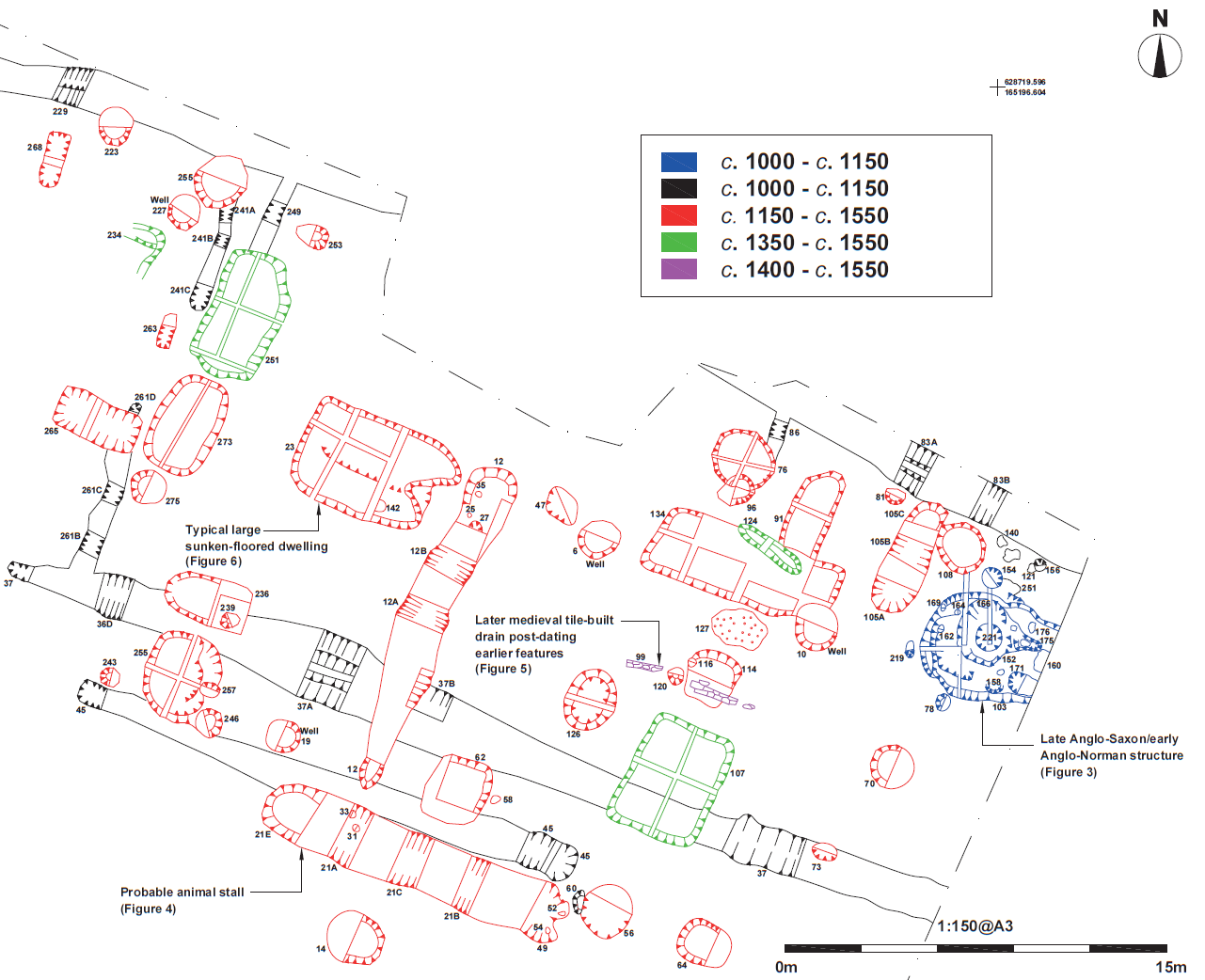
Fig. 2 Phased site plan.

Fig. 3 Late Anglo-Saxon/early Anglo-Norman structure.

Plate I Anglo-Saxon/Anglo-Norman sunken-floored structure 103 looking east (2 x 2m scales) showing a partly backfilled slot cut through Ditch 81 in the foreground.

Fig. 4 Typical larger sunken-floored dwelling.
Plate II Sub-rectangular sunken-floored structure 273 in the foreground and large sub-rectangular structure 251 in the background (looking north, 2 x 2m scales).

Plate III Sub-rectangular sunken-floored structure (CRN 23) looking north-west. This structure, along with rectangular structure 134, nine metre to the east, was one of the largest sunken-floored structures present on the site (2 x 2m and one 1m scale)
Plate IV The in-situ large fragment of a baluster jug in fabric M1C with splashed green in sunken-floored structure 23. This fragment and the rest of the pottery recovered from this structure provided a date-range of c.1250 to c.1370 (0.5m scale, looking north).


Plate V Medieval storage pit re-used as a waste pit (looking east, one-metre scale). The fills of this pit contained pottery dating predominantly from c.1450 to c.1500, suggesting it fell out of use late in the life of the settlement.


Fig. 5 Probable animal stall.
Plate VI Looking north in the eastern part of the site showing the chalk-lined, tile-based drainage Gully 99 in the foreground and the distribution of rectangular and sub-circular sunken-floored structures and other features in the background (2 x 2m scales and a one-metre scale).


Fig. 6 Later medieval tile-built drain post-dating earlier features.