Notes on some West Kent Roads in Early Maps and Road-Books
Contributions to the next volume are welcome. See the guidance for contributors and contact Editor Jason Mazzocchi. Also see the guidance for peer review.
Search page
Search within this page here, search the collection page or search the website.
Romden Place and its restoration
Sir Andrew Judde
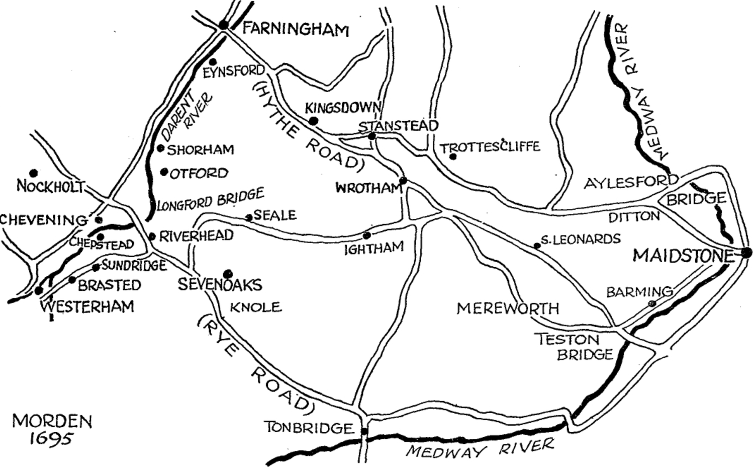
( 85 ) NOTES ON SOME WEST KENT ROADS IN EARLY MAPS AND ROAD-BOOKS. BY E. G. BOX. PBELTMINABY NOTE.—Early maps and road books mark only those roads which at the date of the first pubhcation of the map or book were those most used or most important. Therefore, the absence of a road from map or book is not conclusive evidence that at that time there was no road there. This is true of maps, and stiU truer of road books, which always have contained fewer roads than the contemporary maps of the same place. 1. THE RYE ROAD. This was always one of the three Great Roads of Kent. The earhest maps of Kent with roads mark three Great Roads, London to Dover, London to Rye and London to Hythe, but the earliest road book,1 A Chronycle of yeres, <&c.,z in the edition of 1544 has only the Dover Road ; to this is added in a road-book of 1571 the Rye Road, but the Hythe Road does not appear in a road book till 1675. The table of the Dover Road in A Chronycle of yeres is repeated in John Stow's A Summarie of the Chronicles of England, 1575, as foUows :— 1 A Road-book may be defined as a book containing tables of roads from one place to another with the places passed and the distances between them. The earliest English Road-book was published in 1541. The late Sir George Fordman, who published in 1924 a handbook of Boad-books and Itineraries from 1570 to 1850, had a collection of about five hundred roadbooks, but not all English; I myself have about one hundred, all English. Later road-books such as Paterson's and Cary's published in the eighteenth century, have descriptions of the roads, together with names of gentlemen's seats, inns, particulars of ooaches, etc 2 See Bibliographical Society's Transactions, New Series, 1927, vol. viii., art. by Sir George Fordham, with a reprint of the tables in A Chronycle of yeres. 8 6 NOTES ON SOME WEST KENT ROADS. The way from Douer to London. Erom Douer to Cantorbury xn mUe from Cantorbury to Sittingborne xii mUe from Sittingborne to Rochester viii mUe from Rochester to Grauesend v mUe from Grauesend to Datford vi mUe from Datford to London xii mile The first table1 of the Rye Road in 1571 is in Richard Grafton's A Mile treatise conteyning many proper tables and rules, &c, and is as follows :— Erom Rye to London2 Erom Rye to PlymweU xv. m. from PlymweU to Tonbridge xi. m. from Tonbridge to Chepstowe vn. m. from Chepstowe to London xv. m. The variations in the early routes of the Rye Road from or to London are discussed (with a map) by Captain Knocker in Arch. Cant., vol. XXXVIII, with special reference to the different places at which at different times the river Darent was usuaUy crossed, namely, at Chipstead, Longford between Dunton Green and Riverhead, and elsewhere. Lambarde's map called a " Carde of this Shyre"3 gives another crossing place at Sundridge, the road in this instance coming from London by Cudham and continuing from Sundridge straight to Tonbridge, perhaps by way of Ide HiU. With this one exception aU maps and aU road-books up to the pubhcation in 1675 of Ogilby's great folio Britannia make the Rye Road cross the Darent at Chipstead. 1 This table is repeated in Richard Rowland's Post of the World, 1576, Frank Adams' Writing Tables, 1581, and WiUiam Smith's A Particular Description of England, 1588. Also in a table of highways in A Direction for the English'Traviller, 1636, and in some seventeenth century almanacks, such as Gallon's, 1649, and Rider's British Merlin, 1670. 2 In this table of the Rye Road, Plymwell is a misprint for Flimwell, and Chepstowe a variation of Chipstead. 3 Arch. Cant., vol. XXXIX, with a reproduction of the third issue of Lambarde's map. The date of this is uncertain; I think it is between 1588 and 1696, or at any rate earlier than Symonson's map of Kent. The date of Symonson's map is 1696 (or as Mr. Hannen thought in one instance 1676—; see Arch.Oant., vol. XXX, p . 85). But some authorities think that the copies known today had roads added about 1650. FARNINGHAM EYNSFOR KINGSOOWfl TANSTEAD •SHORHAM •OTFORD NoCKHOlt WROTHA CHEVENING ^iJ^BRASTED SEVENOAKS ESTERHAM \\ KNOLE RIVERHEAD V DITTON S. LEONARDS IGHTHAM MAIDSTO BARM IN MEREWORTH T E S T O N MO£DEN I695 ME.DWAV K!^BIZ WEST KENT IN 1695. From a map by W 'Mam Morden in Camden's Britannia. 8 8 NOTES ON SOME WEST KENT ROADS. The route of the Rye Road in Symonson's map of Kent is also discussed by Capt. Knocker in reference to the road marked by Symonson diagonaUy across Chevening Park from Knockholt Church to Chevening Church. The private Chevening Estate Maps of 1612, 1679, and 17041 confirm Capt. Knocker's rejection of this diagonal road, and the route of the road down the east side of the Park as shown on his (Capt. Knocker's) map. There is no sign of a diagonal road on these estate Maps which are on a large scale of about 12 inches to the mile and obviously accurate. The Chevening Estate Map, 1612, caUs the road on the east side of what is now Chevening Park " the highway from Chepsted to London," while an Estate Map of 1679 labels part of the same road "from Knockholt Pound," and the map of 1704 calls the same part "the way to Knockholt Pound," and the part by Chevening Place " the way to Chevening, Chipstead and Sevenoaks." Erom 1675 the more usual route of the Rye Road seems to have been across Longford Bridge through Riverhead to Sevenoaks and Tonbridge. Britannia in 1675, in its strip maps of the Great Roads of England and Wales on a scale of one inch to the mile, and in a letterpress description, describes the road in detail, from Bromley through Farnborough up Rushmore Hill, with the Porcupine Inn2 on the west (right) side of the road at the top, with turnings off the road on the same side to " Nocholt vulgo NockweU." The road passed Knockholt Pound (not marked), then turned due East along the ridge for half a mile and then straight down the hiU-side by " a steep and difficult passage." This was on the west side of the present Stockholm Wood, though then the Downs were open. In the map in Britannia Dunton Green has no houses (1675), Longford Bridge is named, Riverhead has houseson either side—" a small thoroughfare," then the road passes "Lady Boswell's Park" (later Bradbourne Park) and so to 1 Lord Stanhope kindly lent me these maps some years ago. 2 The Porcupine Inn, now lost, was still there in 1785 (Paterson's British Itinerary). NOTES ON SOME WEST KENT ROADS. 89 "Sevenoke vulgo Sennoke "—" a town with a well provided market on Saturdays." The road down the hiU-side with a " a steep and difficult passage" was stiU on the maps in 1821, though a road with an easier gradient on the line of the present Morant's Court HiU Road (or Star HiU as it used to be caUed) was made or altered under a Turnpike Act of 1748, and perhaps was in use for wheeled vehicles at a much earher date. The two roads, old and new, are in Andrews, Dury and Herbert's Map of Kent in 17791, and in Hasted's Map of Codsheath Hundred in 1778, also in the first Ordnance Survey Map of Kent of 1801, and in Greenwood's Map of Kent of 1821. But the Ordnance Survey Map of 1819 has only the lower part of the old road and even this in the map of 1871 had become a footpath. Ogilby in Britannia in 1675 marks a turning on the west side of the road at the foot of Madam's Court Hill and labels it "the Coachway." Perhaps this was a road with easier gradient which preceded the Turnpike Road of 1748. Ceha Eiennes2 in her Through England on A Side Saddle, when she was riding from Tunbridge WeUs towards London about 1700, writes of " a compass round a great hiU used by coaches." Her " great hiU " was certainly Morant's Court HiU ; was her "compass round " it the " coach way " of 25 years earher in Britannia ? 2. THE PILGEEMS' WAY.8 No continuous road or way under the North Downs from the Surrey boundary the whole way to the Medway is marked on any map prior to Andrews's map of 1779, but a portion is marked as far as Morant's Court Hill in several 1 Andrews's map was published first in 1769 in twenty-five sheets, in a scale of two inches to the mile. The edition of 1779 is, I think, only a reprint. a Celia Fiennes' great rides—she rode one thousand miles one year— were recorded in a diary which was not printed till 1879. 8 My notes supplement Mr. EUiston Erwood's paper in Arch. Cant.y vol. XXXVII. 9 0 NOTES ON SOME WEST KENT ROADS. maps1 published between 1686 and 1720 and in the Chevening Private Estate Maps. This portion was part of a road from Surrey to Dartford and the Thames by way of the Darent VaUey (left bank). The maps mentioned in the note mark a road from Forest or Forst Green (now Force Green) near Westerham, past Ouenidg Green (later Ovenden Green) across what is now Chevening Park, by Turban (Turvins Farm) and Morant's Court (House), across the London road, down the left bank of the Darent, past Filston, Shoreham, LuUingstone and Farningham to Dartford. This road under the Downs was caUed near Westerham in 1571 "veneUa subtus montem," and in 1574 "The King's highway from Shoreham."2 Itis caUed " the underbill road " in Chevening Park in a letter dated October 4th, 1769, written by Lord Stanhope's agent, Mr. Brampton, to Lady Stanhope in Geneva, when Lord and Lady Chatham were living at Chevening Place which had been lent them by Lord Stanhope.8 This is also the name given to the Pilgrims' Way nearer Otford in a Perambulation of the bounds of that viUage in 1794.4 The Pilgrims' Way through Otford viUage and beyond under the Downs through Kemsing and Wrotham to the Medway is not marked on any map until Andrews's map of 1779. That map marks a short piece of road north of Kemsing village, labelling it "The Upper or Pilgrim Road" (not, be it noticed, the Pilgrim's or Pilgrims' Road) .5 Hasted in his map of Codsheath Hundred, 1778, repeats the same name in the same place, and also labels another short stretch of road between Upper HaUing and Whorne's Place "the Pilgrim's Road." This latter is not in Andrews's map. 1 These are Lea's Environs of London, 1686 circa, Morden's Map of Kent, 1695, Overton's Environs of London, 1720 circa. 2 Leveson-Gower : Parochial History of Westerham, 1883, p. 1. » " Lord Chatham at Chevening," 1769, unpublished, 1855. * From a MS. in the possession of H. Martin, Esq., of the Drive, Sevenoaks (1931). 6 It is said t h a t " Pilgrim Road," in otherparts of England means only an old road. NOTES ON SOME WEST KENT ROADS. 91 3. ROADS nsr THE DARENT VALLEY. No map marks any road in the VaUey before 1688 circa, and no road book until 1772. The first maps to mark a Darent VaUey road are Lea's Environs of London, 1688 circa and Morden's map of Kent, 1695, and the first road book the second edition, 1772, of Paterson's Roads. The road given by Lea and Morden is on the left bank and is part of the old road from Surrey to Dartford and the Thames. Early maps have one road only, either a left or right bank road. On the other hand roads on both banks of the river are in Overton's Environs of London, 1720, and Bowen's Kent, 1751. The table of the Darent Valley road in Paterson's Roads of 1772 with the stages and distances between them is this :— DARTFORD TO SEVENOAKS. To Darent, Kent Sutton Street Famingham Aynsford Shorham Otford Sevenoaks — 1 21 1 2 | U 3 2 3 51 61 9 101 131 Maps which have a left bank road only are : Morden and MoU's Kent, 1701, MoU's Environs of London, 1710, Bowen's Kent, 1720, Seutter's Environs of London, 1735 circa, Dodsley's Kent, 1744, and Geographia: Kent, 1748. While maps with a road on the right bank only are Lea's Kent, Surrey, Sussex and Middlesex, 1699 circa, SeUer's Kent, 1710 circa. On the evidence of the maps the roads in the Darent VaUey changed very Uttle century by century up to about 1800, when the road on the left bank which formerly kept to that bank aU the way to Farningham, passing close to the west side of LuUingstone Place, diverged after passing Shoreham Castle Farm and crossing the river joined the road on the right bank. Probably in 1772 the left bank 92 NOTES ON SOME WEST KENT ROADS. road was becoming less used than that on the right bank and became in a few years a mere lane, as it remained until only a few years ago. 4. THE HYTHE ROAD EROM KINGSDOWN TO THE MEDWAY. In early maps, the Hythe Road from London has one usual route, except for slight variations, until it reached Kingsdown, but after Kingsdown it usually split into two alternative roads. In Symonson's map, 1596 (or 1650 circa), one branch crossed the Medway at Aylesford and another at Teston, no road running direct to Maidstone, which apparently was usuaUy reached by cross-roads, on the east side of the river. According to Symonson the way to Aylesford Bridge was by Stanstead, Trosley, Addington, Larkfield, Ditton, and to Teston Bridge by Wrotham, St. Leonards and Otham. Ogilby in Britannia, 1675, gives the road to Aylesford Bridge but the alternative road is direct to Maidstone Bridge by "Nebucan" and "Off am ahas Of h am" and not to Teston. Thence (says Ogilby) " an indifferent straight way, but very woody brings you to a stone bridge of 5 arches leading into Maidstone, large and well-built, its streets well ordered, having several graceful houses and several good inns." Kingsdown, Ogilby says, was " a smaU discontinued viUage " and Stanstead " a disunited village," while Aylesford affords "good accommodation" and " the bridge over the fair river Medway is stone with 7 arches." As to Wrotham, a bye-way turning off the Hythe Road near " Rotham " leads to Famingham "by the coneywarren." Morden's map, 1695, has different roads from Ogilby, namely, one by Stanstead, Ditton and Buckland to Maidstone Bridge, with a branch to Aylesford Bridge, a second road going by Wrotham and St. Leonard's to Teston Bridge with a branch by Barming Church and Cross to Maidstone Bridge, and a third road to Teston Bridge by way of Mereworth Street. NOTES ON SOME WEST KENT ROADS. 93 The maps of about this date do not agree in the routes given to the Hythe Road. Lea, 1699 circa, in one map gives only a direct road to Maidstone by Wrotham and no roads to Aylesford and Teston Bridges, but in another map of the same date gives roads to Aylesford Bridge and also to Maidstone Bridge. Later maps agree with Morden's map of 1695, until a settled and definite route was given to this portion of the Hythe Road by the Turnpike Act of 1765. A table of the earher road of 1676 is given thus in Mr. Ogilby's Tables of his Measur'd Roads : M. 19 Wrotham 27 Maidstone Erom London to New Cross 4 Lusam Ley 2 Eltham Southend Foot's Cray 8 Farningham 5 Wrotham 2 Offam 6* Maidstone Turnam Street No. 9 LONDON to M. F. 25 3 36 2 5 7 2 6 10 6 2 8 M. F. 57 2 69 4 M. 41 Ashford 49 Hith Barsted Park Gate 6 Haresham Sandway Lenhamhaugh Bradenhaugh 6 Hothfieldhaugh 9 1 2 Ashford 3 6 WiUesburrough 4 Selling 6 6 Pedling-street 4 Hith 5 4 8 1 Notes.—The place in capitals is a City, and the places in italics are market-towns. Maidstone with an asterisk is a Post-Town. The miles on the left of the names of places are the computed miles, while the miles and furlongs are the measured miles, measured that is by the wheel, a sort of perambulator wheeled by a man. The distances at the top of the table are the distances from London. There is a drawing of the " wheel" on the title page of Ogilby's Britannia, 1675. " Mr. Ogilby's Tables " of 1676 include five roads in Kent, namely to Dover, Deal and Sandwich, Hith, and Rye, and also one across the Thames to Chelmsford by Gravesend and West Tilbury. 9 4 NOTES ON SOME WEST KENT ROADS. For comparison with this last Table I give the Table of the new Turnpike Road from the sixth edition of A New and Accurate Description of the Roads by Daniel Paterson, 1784. LONDON to Hithe and Folhstone by Maidstone To New-Cross, Kent r. to Leigh Eltham Sedcup Foots Cray Birchenwood Earningham Kingsdown Wrotham Nepeker Wrotham Heath Larkfield Maidstone Bersted Ashford Hithe Folkstone — 21 2 3 1 2 4 31 3 1 1 4 41 3 17 121 4£ 3 | 6 8 11 12 14 18 21* 24| 25£ 261 301 35 38 55 671 72 The new Turnpike Road in Andrews's Map of Kent, 1779, agrees with this last Table, and so also the strip-maps, after the pattern of those in Britannia of a hundred years earher, in Paterson's British Itinerary of 1785. Mr. Ogilby's Tables of his Measur'd Roads, 1676 from which I have given a Table of the Hythe Road, begins a long series of Road Books which ended only in 1794. There were at least 24 editions, which at first were long, narrow, slim books bound in rough sheep-skin and later httle square duo-decimos bound in sheep or calf, and usually today very much worn by use, nearly always wanting the large map of England and Wales with roads. I have a copy.of the 1676 edition and ten or eleven other editions, only one of which preserves the map. My copy of the first edition is bound up with The English Traveller's Companion by NOTES ON SOME WEST KENT ROADS. 95 " A Lover of his Countrymen " of the same year, which contains diagrams of the Great Roads in five sheets; one oi the South-East, South, and South-West Roads, includes the Great Roads of Kent. This little book has on the title page the name of its first owner, " Geor. Shippe, July, 1676." The smaUer editions were caUed Ogilby and Morgan's Pocket Book of the Roads, and later The Traveller's Pocket Book. At first the Hythe Road is given as in the Table I have copied but later editions from 1758 give alternative roads to Aylesford and Maidstone Bridges. Other road books of this period have similar tables, such as A Description of all the Counties of England and Wales, 1728, and Geographia Magnae Britanniae, 1748. 5. THE MAIDSTONE ROAD : WESTERHAM TO MAIDSTONE. Up to the pubhcation of Andrews's Map of Kent, 1779, no pubhshed map marks this road from Westerham to Maidstone as a continuous road in the vaUey of the Holmesdale. There are always gaps in the road, which suggest that traveUers in wheeled vehicles had to make long detours, The Chevening Estate Map of 1612, for instance, which marks certain roads clearly and accurately as far as can be judged, has no road from Brasted Street either to Westerham or Sundridge, though in the Estate Map of 1679 these roads appear. Lea's Twenty Miles Round London, 1686, has a road from Westerham to Borough Green, but no road from Riverhead to the foot of Seal HoUow Road. Apparently traveUers in wheeled vehicles went round by Sevenoaks Vine. Other maps of that date have the same gap in the Maidstone Road, east of Riverhead, though the maps in Ogilby's Britannia, 1675 suggest that there was a road of some sort, perhaps, one fit for horsemen and pack-horses only. This stretch of road is crossed today by streams which in 1675 were probably unbridged and liable to floods. The first edition of A New and Accurate Description of the Roads by Daniel Paterson, 1771 has a table of a road 9 6 NOTES ON SOME WEST KENT ROADS. from Maidstone to Farnham through Riverhead and Westerham. MAIDSTONE to Farnham Ditton, Kent GaUick HiU Igham Seal Riverhead Sundrish Brasted Westerham Limpsfield, Surry Oxted Street Godstone Green Bletchingly Nutfield Ryegate Buckland Dorking Abbinger Hammer Alburry GuUdford Farnham 5 21 2 | 21 2 I 2 2f 1* 21 If 11 4 21 4 5 21 41 11 31 81 10f 131 16 18' 18| 20| 231 25 271 291 301 341 36| 40-| 45f 48 521 631 This road seems to have crossed the top of Oldbury Hill, near [Igtham, instead of passing along underneath on its southern side by the Crown Inn as it does today. Andrews's map of 1779 has the altered road and labels it " The New Road." It was made under the Turnpike Act of 1765. Paterson gives it in a strip-map in the first edition, 1785, of his British Itinerary and so does Cary in a table in his New Itinerary of 1798. This seems also to be the road in the second edition, 1772, of Paterson's Roads in which the stages are Ightham, Seal Charte, Seal, Riverhead, and not as in the table I have just copied from the edition of 1771. The apparent absence of a usual road from Wrotham direct to Maidstone at one time may have been due to the denseness of the intervening woods and the deep clay of the country. Ogilby in 1675 said that traveUers went from NOTES ON SOME WEST KENT ROADS. 97 London to Maidstone by way of Rochester, rather than by Famingham. The maps for a hundred years after that draw wide woods and unenclosed commons. Even today it is easy for a stranger to get lost in the scrub of the Mereworth Woods. 6. SEVENOAKS TO DARTEOED OVER THE NORTH DOWNS. This ancient road was in use at the end of the 18th century as is proved by the squat mile-stone still existing in the hedge at the north-west corner of the junction of Child's Bridge Lane and the Pilgrims' Way, with an illegible date on the top, and on the sides the distances to Sevenoaks, Dartford, Bromley, and MaUing. The date marked on it is 17 something, probably a year in the second half of the century when, as my road-books show, mile-stones were being erected on many roads. This way to Dartford certainly started from Sevenoaks Vine by Seal HoUow Road. At the foot of this latter road it crossed the open Steadies or Stiddolphs Heath which then lay on either side of the Maidstone Road, and by the open heath or later fields, unbuilt on ten years ago (1931), reached the ancient Child's Bridge Lane which stiU remains a lane, though crowded with houses and runs from Seal to join the Pilgrims' Way.1 From the Pilgrims' Way the road reached Dartford by way of Romney Street or Woodland, Eynsford and Famingham. Andrews's map, 1779, is the first to give the lanes which this ancient way to Dartford foUowed. I have aheady described another ancientway to Dartford from Surrey by part of what is now caUed the Pilgrims' Way and the left bank of the river Darent. This road to Dartford could have been joined in or near Otford by more than one old track from Sevenoaks which may have formerly been in pubhc use, but are now in part only footpaths or private (it is not possible to tell from old maps whether a way was 1 Seal Hollow Road is markod unnamed in Lea's Environs of London, 1686 circa, Morden's Kent, 1695, Seller's Kent, 1710 circa, and Overton's Environs of London, 1720 circa. 11 98 NOTES ON SOME WEST KENT ROADS. pubhc or private). To-day a footpath across the fields and the Darent joins the Maidstone Road to Rye Lane which runs from the London Road at Dunton Green to Otford and so onwards by the Darent Valley roads to Dartford. This footpath can be reached from Sevenoaks by the London Road and ShorehamLane, which to-day runs above Riverhead Churoh to the Maidstone Road. Andrews's Map, 1779, marks a circular green at the junction. Between it and the river there used to be the last unenclosed remnant of Codsheath, the Heath which gives its name to the Hundred in which Sevenoaks is, whose name survives only in Cod's Corner on the edge of Montreal Park, where it is named in the modern 6-inch Ordnance Survey Maps. Shoreham Lane itself is marked though unnamed in several maps of a hundred and fifty years ago, beginning with Andrews's Map, 1779, but is named in the 6-inch O.S. maps. Andrews's marks the road across Codsheath Heath (though the Heath is not named) and the river to Rye Lane, but then stops. 7. THE GREAT ROADS OE 1675. Ogilby in Britannia describes the three great Roads of Kent. "The Dover Road," he says, " affords in general a very good and well beaten way, chiefly chalky and gravelly, and none better provided for conveniency of Entertainment, being the most frequented Road in England ; leading to the readiest passage for France, and to the Downs upon all occasions." The Rye Road : " Tis a weU-frequented road as conveying you to the readiest passage to Diep and Haur de Grace in Normandy in France ; whence you have the shortest land passage to Paris ; but for quality the way is not altogether so commendable, especially beyond Tunbridge." The Hythe Road is " a reasonable good road to Famingham, but less commendable to Hith, being generally rough, hard and narrow, and not much frequented; travellers choosing rather to pass by Rochester to Maidstone than by either of the ways here exhibited, yet it is not unprovided for fitting entertainment."