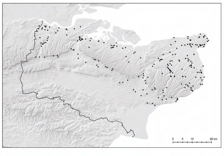
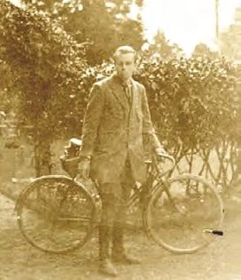
KAS Newsletter, Issue 112, Winter 2019

Otford Experimental Archaeology Lees Court Estate Lullingstone Church Field Roman Villa – 2019 season Using palaeolithic flints from Cudham An update on excavations in 2019 The Roman Villa at 70 THE OLDEST AND LARGEST SOCIETY DEVOTED TO THE HISTORY AND ARCHAEOLOGY OF THE ANCIENT COUNTY OF KENT № 112 Winter 2019 10 23 46 28 LYMINGE RE-INVESTIGATING THE ORIGINS OF THE CHURCH 02 | Kent Archaeological Society PresidentDr Gerald Cramp Vice PresidentsMr L.M. Clinch Mr R.F. Legear Hon. General SecretaryClive Drew secretary@kentarchaeology.org.uk Hon. TreasurerBarrie Beeching treasurer@kentarchaeology.org.uk Hon. Membership SecretaryMrs Shiela Broomfield membership@kentarchaeology.org.uk Hon. EditorTerry G. Lawson honeditor@kentarchaeology.org.uk Hon. CuratorDr Elizabeth Blanning elizabeth.blanning@kentarchaeology.org.uk Hon. LibrarianRuiha Smalley librarian@kentarchaeology.org.uk PressVacant NewsletterRichard Taylornewsletter@kentarchaeology.org.uk WELCOME FROM THE EDITOR Welcome to the Winter 2019 Newsletter. Following a busy summer, we have a bumper winter issue packed with abundant and intriguing material and discussion. It seems a long time since the last issue back in Easter. Unfortunately, we didn’t have enough material to run with a summer issue. However, given the content of this issue, I now understand why – it seems like the entire membership was involved in fieldwork, surveying or research during the summer, and that can’t be a bad thing. While editing the many articles in this issue, the theme that continually jumped out at me was the invaluable efforts of the many volunteers that took part and made the projects so successful. On a personal level, it was equally rewarding to help train and instruct many of these volunteers in fieldwork techniques, recording practices and survey methods. As a former teacher, it gives me great pride to then witness volunteers take on new and complex tasks, work through a problem, solve it and contribute to the archaeological record. Engagement is a great way to increase the Society’s membership – getting people involved, trying out new activities, learning new skills and making contributions to our county’s fantastic archaeological and historical heritage. The Newsletter remains an outlet for this fantastic heritage and the tremendous work going on out there. It exists so that you, the membership, may communicate a broad range of topics devoted to the history and archaeology of Kent. I continue to encourage as many members as possible to think about writing articles and help inform the broader historical and archaeological community of what is taking place in our heritage-rich and diverse county. Please continue to forward articles or notices to newsletter@kentarchaeology.org.uk Enjoy this issue and a Season’s Greetings to all readers. Richard Taylor The editor wishes to draw attention to the fact that neither he nor the KAS Council are answerable for opinions which contributors may express in their signed articles; each author is alone responsible for the contents and substance of their work. Front cover image courtesy of the Pathways to the Past Project, Lyminge. Winter 2019 | 03 CONTENTS FEATURES Excavations at East Farleigh 2019 Church Field Roman Villa, Otford – 2019 season Data for Early Anglo Saxon Burials IOTAS and the Places of Worship Survey Re-investigating the Origins of the Church at Lyminge Experimental Archaeology using Palaeolithic Flints Lees Court Estate Excavations 2019 – A Note from the Countess Sondes – Excavations in Stringmans Field 2019 – Excavations in Woods Court Field, Badlesmere 2019 – Excavations in Badlesmere Bottom Field 2019 – Volunteering with KAS at the Lees Court Estate – Digging at Badlesmere Bottom with KAS – Lees Court Excavation: Bexley YAC with Fred Birkbeck 98 High Street, Maidstone Iron Age Village in Lenham Under Threat Lullingstone Roman Villa at 70 President’s Report on Conferences and Forums 2019 High Halstow Duck Decoy Allen Grove Local History Fund 06 10 14 16 19 23 28 28 29 34 36 38 40 41 42 44 46 52 54 56 № 112 WINTER 2019 6 mi. 10 km 19 04 54 46 42 28 16 23 10 06 44 President’s Column Cobham Landscape Detectives Book Reviews An Interview With... Alan Ridgers Letters to the Editor Notices Membership Matters REGULAR 04 04 09 13 18 18 55 04 | Kent Archaeological Society Much has happened since the Spring issue of the newsletter, both within the Society and outside. On 19th July 2019, English Heritage celebrated the 70th anniversary of the start of the excavation at Lullingstone Roman Villa. A history of the excavations is included in this issue. Lees Court The Society continues its excavations at Lees Court with spectacular results. The excavations have shown that Woods Court Field was the site of a significant Bronze Age Settlement some 3,000 years ago where a wealth of evidence has been uncovered. This year, several pits have been excavated which have yielded many large pieces of pottery, lithics, potboilers and parts of several loom weights. The star find was a complete loom weight measuring 16cm high found in a pit with masses of pottery. Gordon was the lucky archaeologist. Well done! Further details are covered in this issue. Kent History Federation It is with great sadness that I, as President of your Society, have to report the winding up of the Kent History Federation. The last meeting of the Federation was held on 3rd July last at the Maidstone Library and Archive Centre. It started life as the County PRESIDENT’S COLUMNLocal History Committee in 1935. The Federation published its highly successful journal from 1975 until the last issue numbered 88 appeared in March this year. The journal gave excellent service in publishing details of affiliated Societies, future events, books and articles by their members. I have written to the Federation’s affiliated Societies inviting them to join the KAS as our Society can fill some of the gap left by the Kent History Federation. Government Consultation on Proposed Changes to the Treasure Act As agreed in Council and after consulting members of this Society by email, I submitted this Society’s response to the Department for Digital, Culture, Media & Sport (DCMS). I have yet to see any outcome from the Department. Conferences and Forums Reports on conferences and forums are given elsewhere in this issue. Have a good Christmas, and I look forward to seeing you at a conference, at an excavation or just at the AGM in May. Gerald Cramp, President COBHAM LANDSCAPE DETECTIVES... HASTA LA VISTA! Our three-and-a-half-year Lottery funded odyssey concluded in June with a 2-day exhibition in Cobham Village. As part of the celebrations, we commissioned an artist to paint a series of views of the landscape and key features that we had investigated. Surrounding this article are two of those paintings, published here as an exclusive! One shows the medieval landscape as it may have looked in the AD1300. By Andrew MayfieldThe second shows Cobham Villa, a site investigated by the KAS under Peter Tester’s direction in the 1960s. Since the last update in edition 111, we have completed our work at Peggy Taylors Hill, near Cobham Hall. The vast hole we recorded had been dug in the 20th century to dispose of a series of cleared trees, explaining the mix of golf balls and Tudor pottery! The site of the Tudor building appears to have been lost when the hole was dug. In late May we carried out geophysical surveys of the possible barrow in Ashenbank Woods and the Cobham Villa site. The barrow survey was inconclusive, but the Villa survey showed up additional features to the North of the main site. Incredibly a Georgian water pipe had been laid between the two buildings recorded by Tester, without damaging either of them! Winter 2019 | 05 Post-June, the Landscape Detectives have been busy in their other guise as the Shorne Woods Archaeology Group. They have supported community archaeology projects on Romney Marsh, with the 5th Continent team and in the Darent Valley, with the Darent Valley Landscape Partnership. Across the various elements of the Lees Court Estate Project, they have been busy supporting Richard Taylor, Fred Birkbeck and Keith Parfitt’s projects. They also found time to explore our Mesolithic site in Shorne Woods Country Park further, with 5,000 lithics now recorded! In August the Group were invited by Cobham Hall’s Heritage Trust to investigate one of the ponds in Lady Darnley’s garden. In true Landscape Detective style, we think we have found another reservoir, perhaps built to supply changes to the garden devised by Humphrey Repton. We hope to have more news on this in due course. TopFig 1: Medieval landscape, looking southwest over Cobham Parish and its Manors in AD1300 (with thanks to Roger Cockett for his research and input)BottomFig 2: Roman landscape, looking south from Watling Street at Cobham Villa Artwork (Figs 1 & 2) reproduced with kind permission of Alan Marshall of Heron Recreations We’ll be back! This Autumn we have reconvened as Landscape Detectives, in partnership with Victor Smith and the Historic Defences Committee, to explore a World War II site. As we discovered previously at Ashenbank Woods and in Shorne Park, there is plenty of evidence for post-war use of the structures. This work will continue through the Winter… in 2020 we hope to launch an exciting new project in Cobham village. Keep an eye out for further updates! I want to conclude by offering my thanks for the friendship and dedication shown by all Cobham Landscape Detectives, in all weathers, seasons and across most time periods. We have produced a booklet on the project, which we hope to have printed for a 2020 release! The fun doesn’t stop here, however! Head online to keep up to speed at ArchaeologyinKent on facebook, @archaeologykent on Twitter, www.shornewoodsarchaeology.co.uk or by contacting Andrew on 07920 548906 or andrew.mayfield@kent.gov.uk 06 | Kent Archaeological Society EXCAVATIONS AT EAST FARLEIGH 2019 By Stephen Clifton The Maidstone Area Archaeological Group (MAAG) activities began in 2019 with a magnetometry survey and a resistivity survey of a 30m x 120m section of the site (Fig 1), which showed some promising anomalies and a great deal of background noise (see Issue 109). We subsequently dug four trenches using a mechanical digger. The first trench, (19A), was intended to pick up two late Iron Age ditches which we had traced the previous year, and also to see the rest of a flue-like feature which had been dated to the fifth century AD, sub-Roman rather than Anglo-Saxon. It was also meant to identify the part of the features seen in the survey data. Trench 19A was ‘L’ shaped and measured 8 m x 4 m x 4 m. The most recent feature that we encountered was the circular end of a corn-dryer associated with the flue feature seen in 2018 (Fig 3). We found that there was a whole pot buried in the base of this feature, surely a cessation deposit. Tentative dating of the vessel agrees with the earlier dating of this feature, as sub-Roman, 400 to 450 AD (Fig 4). Interestingly the flue and stokehole appear to be secondary features, with the primary flue blocked, but disappearing into the baulk, indicating continued re-use of this structure. The Iron Age ditches were also traced across the trench. One of them appeared to terminate or possibly change direction against the northern baulk. The other continued across the trench in a straight line and is probably a palisade fence. We also picked up another ditch terminus on the western side of the trench, along with some small stake holes. This feature appears to be in alignment with another ditch, running east/west, seen in 2013, which held an Iron Age ritually deposited pot containing cremated bones. TopFig 1: Site plan BottomFig 1a: First trench Winter 2019 | 07 Located close to the corn-dryer were two cremation burials, each containing two vessels and a small quantity of cremated material. These have yet to be analysed, however tentative dating of the pottery appears to put these at 70 to 120 A.D. The archaeological features in the rest of the trench proved very difficult to work out, as there were no finds associated with it to guide us, but it does appear that we have been digging part of at least one large structure. On the south side of the trench, we identified a flat area containing ephemeral features, a ring of charcoal-rich soil, a couple of stake holes and what appears to be an arc of stones. Alongside this, we discovered a man-made bank of stones and another intersecting it, with a change in level between. These features are seen on the north side of the trench heading into the baulk to the north and east. We hope to follow these features next year. During the initial opening of our second trench with the mechanical digger, we encountered the top of a vessel, at a relatively shallow depth. This turned out to be another cremation grave, holding three vessels, and a brooch. Again dated to the late first century, early second century AD. We also identified what appeared to be a row of three postholes aligned north-east south-west. There was no visible sign of any feature resembling the magnetometry data. Top, leftFig 2: Plan of trench 19A Top, rightFig 3: Corn-dryer MiddleFig 4: Sub-Roman pot as cessation deposit from ‘Corn-dryer’ BottomFig 5: Plan of trench 19A 08 | Kent Archaeological Society In the third trench we encountered a ditch running east-west, with a stake-hole at one end. There was no dating evidence for this feature. This year’s discoveries are significant and demonstrate evidence of Roman activity before construction of the buildings to the north, probably in the latter part of the second century A.D. The cremation burials appear to be in two distinct groups, rather than being part of a formal cemetery, with one group perhaps of a higher status than the other. We will likely encounter more burials in future excavations in this area. The location of the burials could be due to the proximity of the earlier Iron Age features, which might have retained a spiritual legacy. Alternatively, there may have been a road nearby, possibly in much the same location as the modern road following the course of the river, and it was not uncommon at this date, for burials to occur at the roadside. However, no such road has yet been identified. The corn-dryer is also significant, as it demonstrates continued activity on the site after the third-century buildings to the north have collapsed or been demolished. As yet though we have found no contemporary structures to accompany this late feature. Top, leftFig 6: MAAG excavting 1st century cremation burial Top, rightFig 7: Biconical beaker of Monaghan class 2G1 in North Kent fineware c.50–100 AD MiddleFig 8: Colchester ‘Crossbow’ brooch 70 AD–110 AD BottomFig 9: Cremation burial Winter 2019 | 09 BOOK REVIEWS Fun and Frivolity – Nineteenth Century Amusements in Gravesend By Lynda Smith A fine account of a small Thames-side town and the multitude of entertainments that emerged as it grew into a popular Victorian resort. Lynda Smith’s book chronicles the rise of Gravesend as a holiday destination with all the Victorian recreations which that entailed, followed by the sudden “decline into a workaday town with all the amusements for its size and type”. Lynda Smith identifies the rise as a holiday resort was dependent on three factors: the fashion for salt-water bathing; the position of the town by the Thames and the advantages arising from its accessibility to London via the introduction of the steamboat. These factors are discussed in detail, as is the inevitable decline. What emerges are curious insights into the mindset of Victorian values and entertainment ideology, alongside a town’s development, the legacy of which is still visible in parts today. As a resident of Gravesend, I found Fun and Frivolity familiar, engaging, and highly informative; its insight to a curiously unfamiliar world challenges the previously held perceptions of a workaday town. The surviving buildings and their rekindled past now taken on a new aspect, and that is a good thing. A must-have for all residents of Gravesend, and colourful, enjoyable addition to the social history of Kent. Fun and Frivolity costs £11.00 and may be bought at the Tourist Information Centre in Gravesend Market or else by post from Mrs Sandra Soder, Secretary of the Gravesend Historical Society, 58 Vicarage Lane, Gravesend, DA12 4TE for £14.00 including postage and packing. Please make cheques payable to the Gravesend Historical Society. Knole Revealed By Nathalie Cohen and Frances Parton Accessible, informative and entertaining – a first-rate account of the conservation, archaeology and history of Knole. Knole Revealed outlines the discoveries made during recent conservation works to the interior and exterior of this famous English house. What emerges is how much has been learned about the property since works began in 2007, courtesy of the National Trust and a generous grant from the National Lottery Heritage Fund. Nathalie Cohen and Frances Parton provided a multi-faceted account that is not only rich in facts but leavened with images detailing various insights into Knole’s past. To demonstrate how this Jacobean gem has been perceived by many over time, the book draws upon a multitude of material, from building phases to hidden treasures found under floorboards, and the graffiti and inscriptions found throughout the property. As the title suggests, the authors present a book that creates a blend of conservation and interpretation of both the property and the internationally significant collections housed within, without neglecting the less grand and often unseen components. A book of discovery and technical study featuring some fascinating revelations of a well-known historic property. Knole Revealed costs £10.00 and may be purchased at https://www.mola.org.uk/knole-revealed-archaeology-and-discovery-great-country-house For more information about Knole visit: www.nationaltrust.org.uk/knole 10 | Kent Archaeological Society By Kevin Fromings CHURCH FIELD ROMAN VILLA, OTFORD 2019 SEASON We have come to the end of our 5th season at Otford, and both the Discover Roman Otford Project (DROP) and the excavation are going from strength to strength. With over thirty fully signed-up members, at least twenty-five of us are active in the field (and we do some archaeology occasionally as well). In the summer, some of us took part in the fieldwork at Lullingstone villa, under the supervision of the Darent Valley Landscape Partnership. This year we planned to continue working on the east range, having discovered a hypocaust last year, and a second hypocaust on the last day of the 2018 season (as you do). This work continued, but we had the opportunity to explore a potential connection between the primary and east ranges through the generosity of Brian Thomas, who grazes his sheep on the rest of the field. At this point, I would like to thank Brian, who has voluntarily moved his fences several times to accommodate the scope of the excavation. Thus we have been able to uncover a substantial wall foundation that appears to be the back wall of the main range, and also forms the northwest wall of the east range. The earliest coins we have are from the main range, the oldest being 218AD, so this part of the building is presumed to be 3rd century. Our latest coin date from the east range is 402AD, but this does not necessarily indicate the demolition date for the villa. One of the enigmas surrounding the site is its date of dismantlement (as one of our team calls it). The villa is large – probably the second largest of the Darent Valley villas after South Darenth (we have now confirmed that the east range is 60m long on the outside), and would seem to contain all the elements for a grand house. But it shows signs of, either being built ‘on the cheap’, and all for show, or fell into a decline before being dismantled, possibly in the latter half of the 4th century. We have one datable coin from a sealed demolition context, but the date is 342AD, and we are reasonably confident that the villa was occupied at that point. If we look at an aerial view of the connecting section, we can see several elements that show the evolution of a high-status farmhouse to a grand villa. TopFig 1: Drone image of Church field villa excavation showing the main range on the left, and the east range at the top. North is at the top left-hand corner of the photoOpposite pageFig 2: Northeast corner of main range MiddleFig 3: Potential bath house BottomFig 4: Large hypocaust, along with some of the dig team Winter 2019 | 11 12 | Kent Archaeological Society LeftFig 5: Main range, showing corridor/verandah (with ranging poles – large pole is 2m) and potential courtyard surface (white chalk) RightFig 6: Roman beard trimmers? In Fig 2, the small room at the left (1) has been identified as a kitchen, built onto the main wall sometime in the 4th century. Compared with the other walls the foundations are very shallow. A doorway opens onto what was probably a rough yard. The top corner of the range itself has an in-situ opus signinum floor (2). This year, we have partially uncovered three rooms in the main range, and they all appear to have had opus sig floors, with no tiles or tesserae on top. What appears to be the original main NE wall of the main range (3) still contains some in-situ stones, which is unusual for our site. In the late 3rd or early 4th century, a probable bath house was added to the complex. This building had buttresses at the opposing NW (4) and SE corners. The bath house had a different type of foundation to the main range – shallower, and with a crushed chalk base, whereas the original foundations went deep into the natural, with a flint base. At some point the back – NW – wall of the bath house was extended to join the main back wall of the villa (5). At this point the buttress would have been superfluous to requirements, and was either demolished to ground level, or left as an internal buttress. The NE wall of the bath house appears to have been extended – possibly for privacy’s sake – and forms the NE wall of the east range. How long after the bath house these rooms were constructed is difficult to say. The chalk foundations appear continuous, and either represent good forward planning, or a last minute change of mind. Outside the bath house was possibly a small garden, with a small tree, or vine, initially a sun trap, but a cool shady area once the rest of the east range had been built. The bath house was probably composed of four rooms. The photo shows the caldarum (top centre), the tepidarum (bottom left), the frigidarum, and general changing room are in the foreground. This area is one of our targets for next year, as we need to understand the water system, the villa probably being supplied by springs that are now in a nearby garden. The other hypocaust we uncovered had a furnace just outside the east wall of the east range, and presents a design that we have not seen elsewhere. In September students from the University of Kent at Canterbury carried out sterling work on the front of the main range. We would like to thank them for their efforts in uncovering the opus signinum floor of the corridor/verandah, the main line of the front wall, and a crushed chalk surface that may be the entrance roadway across the main courtyard/garden. Finds from this year have included decorated painted wall plaster, pottery, coins, and the find of the year: a pair of shears, probably for male grooming purposes (Fig 6). We look forward to more evidence of the occupants’ private lives next year. I would like to finish with a huge thank you to all those who have taken part so far. There have been some superhuman efforts to achieve this year’s results. So, why not come and join us next year? Winter 2019 | 13 AN INTERVIEW WITH… Alan Ridgers is a Gravesham Borough Councillor for the Ward of Istead Rise and Kent County Councillor (KCC) for the Division of Gravesend East. A member of the KAS since 1965, Alan was recently appointed ‘Archaeology Champion’ for KCC, a position which compliments his role as Chair of Growth, Economic Development and Communities Cabinet Committee. I began by asking Alan how he came to be interested in archaeology? AR: I grew up in Gravesend and attended Northfleet School for Boys. I was actually in the same class as Victor Smith, current Chair of the KAS Historic Defences Committee. One day, Victor invited me to go fieldwalking at the Springhead Roman site, near Gravesend. Victor told me to keep my eyes peeled, especially for anything ‘green’ on the surface. Within minutes, I caught a glimpse of this small round, green object lying on the ground. I picked it up and, low and behold; I’d found my first Roman coin – a Marcus Aurelius Pontius 161-180AD. It was a ‘ding’ moment. From then on, I was hooked… I wondered who, what, why, when, examining this coin? It was a life-changing moment for me. RT: How did your interests in history and archaeology develop? AR: I joined the Gravesend Historical Society in 1963, and worked at the Springhead Roman site for many years with Bill Penn and Sid Harker. Over the years, I worked on excavations at the New Tavern Fort in Gravesend, the Painted House in Dover, various excavations in and around Gravesham. I served as both President and Secretary of the Gravesend Historical Society. RT: How do you see your role as Archaeology Champion impacting history and archaeology in Kent? AR: Firstly, I’m honoured to be appointed as ‘Champion’. To my knowledge, it is the first time a County Council has appointed such a position. The parameters for the role are yet to be finalised, but I have my views, and they are to see the county’s heritage preserved, ensure it’s accessible and visible. RT: Looking at Kent as a heritage entity, what are the positives to work with? AR: Kent has one of the longest recorded histories and has played a vital role in many of the critical moments in the development of that history. The resulting heritage is astonishing, and we are guardians of that heritage. You see it at archaeological excavations below ground and the considerable diversity of standing buildings and architecture above ground. Sixty million visitors per year pass through Kent; that’s an astonishing number, and I wonder how many of them realise the extent of the heritage that surrounds them? RT: Do you think Kent promotes itself enough as a heritage destination? AR: Yes it does, but of course there is always more to do. I think joined-up marketing is the answer. If you come to see Dover castle you might also be interested in Richborough Roman Fort or the Blockhouse in Gravesend; it’s about add-ons. Visit Kent and Locate in Kent do a great job. RT: Are there any heritage issue that are problematic at present? AR: The range of heritage ownership issues doesn’t always make life easy. ‘Old’, especially when talking about standing structures, often means maintaining the integrity of the structure, which usually comes with complications. There is also the issue of what happens to all the collected archaeological finds? How do you ensure important discoveries are accessible or visible? RT: How would you begin to tackle the long-standing archaeological archive issue? RT: I’m a great believer in utilising technology. The Guggenheim Collection in the USA has an electronic gallery that you can view images of your favourite artworks without leaving home. I’d like to see a day when we have a county archive that records the best images of artefacts for the public benefit. There is a tremendous amount of work to get to that point, but that would be the goal. RT: And achieving that goal….how do you go about it? AR: As an idea, I’d look to have four centres of excellence around the county that archive and curate material from excavations, collections, etc. with a specific heritage theme. For example, at Chatham, you could house a maritime archive, Dover, a military archive, The Weald an agriculture Alan Ridgers Kent County Council Archaeological Champion 14 | Kent Archaeological Society archive and Dartford an industrial archive. Each location would curate and store its material for reference and research, backed up by an electronic gallery for public access. RT: How do you view the role of local archaeological and history groups and the work they do? AR: They’re invaluable. Because I don’t hold a doctorate in archaeology doesn’t mean that I can’t make a genuine contribution to the knowledge of the subject. Varied learning from different periods can be beneficial, and academics can pick it all apart later! The amateur has a pivotal role, and I will be championing the work and contribution they have made and continue to make. RT: Final question…what would you like to have achieved in your role as KCC Archaeology Champion in, say three years? AR: At present, I’ve only got about 18 months to the next county elections, so that is a short time in the context of the subject. I would like to come back if the voters want me. However, in the short term, to get a more comprehensive understanding of the challenges of archaeology, often undertaken on tight time schedules under challenging conditions. It’s not all like Time Team! Understanding our past prepares us for a greater understanding of what the future may hold. RT: Thank you for your time Alan. On behalf of the KAS, I’d like to wish you every success in your new role as Archaeological Champion. Alan Ridgers can be contacted at Alan.Ridgers@kent.gov.uk The opinions/views expressed by Alan are purely his own and do not necessarily reflect the views of KCC. DATA FOR AN EARLY ANGLO-SAXON CENSUS OF SOUTHERN BRITAIN RELEASED Fascinating insights into the early medieval people of southern Britain can be gained from their burial practices. In Kent alone, there are over 240 burial sites consisting of the graves and cremations of at least 5300 individuals of the fifth to seventh centuries AD. Associated with these people were over 13800 objects, a vast array including weaponry, jewellery, glassware, and more mundane items such as knives, beads, and spindle whorls. Studying these assemblages and their locations in the landscape give us important information about past lives. The sheer scale of this information has been difficult to encompass, but digitisation now allows us to collate and present By Sue Harringtonthis data in a publicly accessible and freely available format. The UCL Early Medieval Atlas is pleased to announce the launch of the Beyond the Tribal Hidage burial data. This is the baseline research data of the Leverhulme Trust funded project Beyond the Tribal Hidage: the early Anglo-Saxon kingdoms of southern Britain AD 450–650 directed by the late Dr Martin Welch FSA at UCL Institute of Archaeology, 2006–9. The project aimed to bring together in an accessible format all the available evidence for burial and material culture in southern Britain from the fifth to seventh centuries AD. Over the years Martin had compiled a meticulous card catalogue of sites in the knowledge that only the full deployment and accessibility of the data would allow the fundamental questions of the early Anglo-Saxon period to be addressed with clarity. This ambition was realised as a digital census created by Sue Harrington and Stuart Brookes. The current iteration is a development of an earlier pilot database of Kentish burials, made available via the Archaeology Data Service and published in 2008: https://archaeologydataservice.ac.uk/archives/view/asked_ahrc_2008/ Winter 2019 | 15 The process of data acquisition was one of desk-based assessment by county, followed by discrete searches to both published and unpublished grey literature and other archive material held by county archaeological societies, research libraries, national and county journals, museum day books and accession registers, as well as through various communications with local researchers. In general, it was possible by this additional level of search to add 10 per cent to the number of sites recorded by national and county archaeological registers. Next, discrete county site lists were assembled, and museum and archive visits arranged to view the relevant objects from these national listings. Data was collected geographically in county sets working clockwise around the study region, beginning with East Sussex in November 2006 and finishing in Kent, Surrey, and Greater London in August 2008. This iteration of the dataset also includes listings of new sites appearing between 2008 and 2017. The study area extends south from the River Thames and westwards into Somerset. The downloads comprise: sites table lists of 834 burial sites with grid references; the Individuals table of 12,379 people for whom there ReferencesHarrington, S. and Welch, M. 2014. The early Anglo-Saxon kingdoms of southern Britain, AD 450-650: beneath the Tribal Hidage. Oxford: Oxbow Booksare partial or complete burial records; and the Objects table noting their 26,043 associated artefacts. The three tables can be freely downloaded from: https://www.ucl.ac.uk/early-medieval-atlas/map-data/beyond-tribal-hidage-data The data enables users to explore the nature, distribution and spatial relationships of burial sites in their landscape context. The web page also gives a full list of references and suggested further readings. We are pleased also to announce that Dr Audrey Meaney FSA has permitted us to include pdfs of her 1964 gazetteer of Early Anglo-Saxon burial sites. As originally envisaged, this data is being made public in the expectation that future researchers will be able to enhance and extend its content. The conclusions of the project, as presented in the project monograph (Harrington and Welch 2014) could thus be tested, challenged, revised and extended as others see fit in the future, aware that what is presented here is but one assessment of the wonderfully complex and engaging material for this crucial period of early medieval studies. If you would like further information, please contact: Data content: Dr Sue Harrington FSA s.harrington@ucl.ac.uk Website: Dr Stuart Brookes FSA s.brookes@ucl.ac.uk 16 | Kent Archaeological Society IOTAS AND THE PLACES OF WORSHIP SURVEY – REVISITED By Gordon Taylor In April, May and June (returns had to be in by 24th) of 2002 the Isle of Thanet Archaeological Society (IOTAS) was involved in a project organised by the Kent Archaeological Society (KAS) – possibly at the request of the KCC – under David Carder, to record all the existing (whether in use or redundant) and all the disappeared places of worship in Kent. Our responsibility was, of course, Thanet. Places of worship were not necessarily churches but could be little more than huts, an example being the Friends (or Quakers) meeting place behind Morrisons garage in Broadstairs (Fig 1). The Guidance Notes issued by KAS listed by David Carder, an incredible 80 possible denominations of which Baptist, Methodist etc. are familiar to all but not so familiar I suspect are ‘Friars of the Sack’, ‘Peculiar People’, ‘Jezrelite’ and the more familiar ‘Plymouth Brethren’ of which we hear little now. Strangely, I know another denomination not included, that of ‘Christadelphian’, of which my parents were followers in their youth in the London area and of which faith churches still exist. At the time, the survey didn’t go as far as dividing the Islamic faith into into Sunni and Shia denominations. Thanet was duly divided up into areas by the then lady chair José Gibbs, and I had Ramsgate (east of the High Street) and covering Dumpton. I could think straight away of three or four, but with due diligence, found a few more, then discovered a book in Broadstairs Library, Victorian Churches of Kent. Eventually, I listed eighteen, five of which are no more, one empty and in danger of collapse, another couple in secular use, and so on. Incredibly, Margate had forty-nine places recorded by Carole Davenport and Paul Harrison, who wrote an article about them for the IOTAS magazine Earthworm (Vol. 6, No. 7, Summer 2002). Twenty-five have been demolished, and seven are not in religious use. Jenny Price covered Cliftonville where she found twenty two, half of which are no longer standing. Sue Holton included Minster and Monkton logging six, one of which has gone and two no longer in religious use (Fig 2). Sue also covered Ramsgate West, recording eighteen, of which seven are gone and four no longer in religious use. One could be accessed, and can still be seen, from Thompson’s Passage at the rear of 15 Elms Avenue – it was a Quakers’ Meeting Hall from 1916. These numbers seem incredible, but there are two chapels at the entrance to Ramsgate Cemetery, for instance, and other chapels were tucked away all over (Fig 3). Some are remembered by flats built on the site, such as Zion House Camden Road which was Clover Hill in the past. Others changed denomination such as one in a street that has gone (Bethesda Street) that was Baptist then Primitive Methodist, demolished in the 1950s like so many others (Fig 3). Carole noted that Benjamin Beale (buried at Drapers Homes almshouses in Margate) was a Quaker as was Elizabeth Fry (honoured on Bank of England notes), the latter visiting Thanet to preach shortly before her death in 1845. Birchington and Westgate are not in the file. What about Broadstairs? The late Rosemary Bazell would have covered the town surely, but unfortunately again the Winter 2019 | 17 records are not in the file although I noted eleven existing in this lovely town. I noted that Mormons used to meet in the driving test building at Pierremont House (Fig 4). Gale Sharman covered Northwood area, but again the records are not in the file. I remember her pointing out the first bungalow on the right in Northwood Road (going towards Northwood) being a Quaker meeting house – note the panel high up in the gable. I know of two on the Newington Estate and a synagogue on the Margate Road, so some are without a record. There was a religious house of the Church of England at Acol built 1876 on the ruins of an ancient chapel. Going by the above, there were (not necessarily at one time) one hundred and thirty two places of worship in Thanet without the return from Westgate and Birchington. If nothing else the survey demonstrates how society has changed in the last 120 years, as places of worship close or are redeveloped. I had contacted the KAS for the results of the survey in 2013 (to write an article for the Earthworm) but met a blank, so I am very grateful to José for lending me her file which has enabled me to finally do so with the addition of my various brief notes. Hopefully, one day, the county-wide results will come to light, and the decline of places of religious worship will be researched fully. This article originally appeared in the Spring 2016 edition of Earthworm Vol.10 No.4 – the Newsletter/Magazine of the Isle of Thanet Archaeological Society (www.iotas.org.uk) edited by archaeologist Lauren Figg. GT. Clockwise, from top leftFig 1: Quakers Meeting House in BroadstairsFig 2: Former Chapel, now three cottages in Turner Street, Ramsgate.Fig 3: Star of the East, Edge End Road, Broadstairs, formerly Good Templars HallFig 4: Former chapel in the appropriately named Chapel Place, St Lawrence – now a playschool across from St Lawrence church from 1062 18 | Kent Archaeological Society NOTICES Elections The annual round of Council elections is approaching fast. If you wish to join Council, please go to the Society website from Sunday 5th January 2020 to Sunday 15th March 2020 where you will find the various application forms, documentation and procedural notices to get your application for candidacy underway. Fieldwork Committee The Fieldwork Committee is looking for a new Secretary to assist the Chair, Mr Keith Parfitt, in running this important committee. Key functions will be maintaining minutes from the three committee meetings held each year, managing the grant application process, assisting with the Fieldwork Forum and annual conference. This is a thoroughly enjoyable and fascinating role. If needed the requisite IT will be supplied (Laptop, Office applications etc.) If you are interested in this role please contact keith.parfitt@kentarchaeology.org.uk LETTERS TO THE EDITOR Dear Editor, On behalf of the seven SHAL (Studying History & Archaeology in Lympne) members who attended either or both the training days run by Richard Taylor and Fred Birkbeck on 28 August and 6 September on the Lees Court Estate, I just wanted to say how much we all enjoyed the days and gained both experience and knowledge. On day 1, Richard turned what appeared to be a rather uninspiring looking trench (to our untrained eyes) into a fascinating archaeological site, encouraging us to look carefully, identify and discuss various aspects to gain different viewpoints. He clearly and patiently explained the layers and contexts and the importance of recording each context separately. As he took us through the initial recording process, including measuring and drawing, he answered all questions raised, ensuring we understood and repeating where necessary. The only “downsides” to our day were the initial unexpected rain and that there was very little in the way of finds – not a pot, mosaic floor or burial to be found! However, Richard’s easy-going, laid back approach and sense of humour, together with the friendliness of all others we met, eased any fears we may have had of showing our lack of experience. This made it easy to respond and ask questions and to get the most out of the day. Day 2, after initial explanation of the site and introduction to Trench 4, saw us being left to organise ourselves and continue excavating and recording a section of a ring ditch, which elicited plenty of Neolithic flints and a small number of early pottery sherds. Again, another enjoyable and informative day and our thanks go to Richard and the team. Yours sincerely, Fiona JarvestStudying History and Archaeology in Lympne (SHAL) RE-INVESTIGATING THE ORIGINS OF THE CHURCH AT LYMINGE Over the past decade, excavations in Lyminge south of Canterbury have revealed a wealth of evidence for occupation in the period between the Fifth and Eleventh Centuries. But during the second half of the Nineteenth Century, Lyminge also featured frequently in the pages of Archaeologia Cantiana. The Rector, Canon Robert Jenkins (Fig 2), was actively seeking the church of Queen Æthelburh (latinised as “Ethelburga”), widowed Queen of Northumbria, who traditionally was given the estate of Lyminge by her brother King Eadbald around 633. Jenkins began digging in the church yard during the 1850s. He soon encountered masonry. In concluding on what he had found, Jenkins considered the first Lyminge charter (dated 697 or 712) describing the church as a ‘basilica’ and projected a great three-aisled church on the model of contemporary basilican churches in Italy. This extravagant conjecture has been questioned ever since. However, it has not been possible to re-examine Jenkins’ claims until now. It has taken two years to put together a community-based project, largely funded by the National Lottery Heritage Fund, with additional significant support from the Sutton Hoo Society and the Roger De Haan Charitable Trust, as well as other smaller grants and public donations. The project, ‘Pathways to the Past: Exploring the legacy of Ethelburga’, involves renewing and improving the existing church yard paths and implementing disabled access to the standing Norman church. This creates the opportunity to explore once again the archaeology found by Canon Jenkins, which lies under the path on the south side of the Norman church. By Rob Baldwin TopFig 1: Aerial view Lyminge church from south eastBottomFig 2: Rev RC Jenkins Winter 2019 | 19 20 | Kent Archaeological Society The archaeological phase of the project commenced in July 2019 under the direction of Dr Gabor Thomas of the University of Reading, who has conducted the excavations in the village over the past decade. Much of the work was undertaken by local volunteers, although we also contracted the assistance of Keith Parfitt from Canterbury Archaeological Trust (CAT). Over eight weeks, we established beyond reasonable doubt that the structure found by Jenkins is mid-Seventh Century in date. It corresponds very closely in style to the church of St Pancras within the precincts of St Augustine’s in Canterbury, and also to St Mary’s at Reculver. The stepped nave was separated from the apsidal chancel by a characteristic triple arcade. We were fortunate to recover a fragment of column made of stone from Marquise, near Boulogne, just like the columns at Reculver, which are now preserved in the crypt of Canterbury Cathedral. By finding a small fragment of the west wall, we also established its dimensions, comparable to, though smaller than, the other contemporary churches, being 13.4m long, by 5.3m at its widest. Fragments of white and pink plaster testify to the wall decoration, but we found no surviving remains of either the superstructure or the floor. All we know, therefore, is that the foundations were built using crushed Roman brick that give the mortar a distinctive pink hue. The method of construction suggests that continental masons were imported to supervise the work. It is quite possible that they re-used dressed Roman stone to build the walls, but these have been comprehensively robbed, so we cannot say for certain. In true Victorian fashion, Canon Jenkins chased the walls of the church when he dug them, leaving the interior largely undisturbed. However, this area may not have been disturbed in Victorian times, but it had been heavily disturbed by burials. We excavated eight burials in the end of the chancel, the deepest containing a sherd of the Thirteenth Century. It is likely, therefore, that the Seventh Century church had been demolished and had passed out of memory when burial began in this area sometime after 1200 (Fig 3). TopFig 3: Excavating the Anglo-Saxon chancel at LymingeMiddleFig 4: Plan of Lyminge church KAS Proceedings 1874 BottomFig 5: Launching the Royal Saxon Way, 29 Aug– 1 Sep 2019 Winter 2019 | 21 Excavation has confirmed that Canon Jenkins discovered a church that could plausibly have been built by Queen Æthelburh. However, the elaborate structure he published in the KAS Proceedings for 1874 (in Archaeologia Cantiana X) did not exist (Fig 4). Some thirty years ago, the western end of the extension he described on his published plan as an “Atrium”, was re-investigated by Tim Tatton-Brown and Paul Bennett of CAT. They considered this to be a free-standing structure, and it is now clear it was built of different masonry from the church uncovered this summer, and was apparently much later in date, perhaps just pre-Conquest. It was also on a different alignment from how it was drawn by Jenkins and did not form an extension of the Seventh Century church. The solid linking walls shown on Jenkins’ plan were not found. Jenkins’ plan also ignored the stepping between the nave and chancel to fit better with his projected basilica. Exploring to Left24 Aug site tourRightArchbishop Ceolnoth penny obverse c860-65 LeftWhite wall plaster from the church MiddleStratified middle Saxon potteryRightRed wall plaster from the churchthe south, we found no evidence for further aisles, which thus are revealed as purely imaginary. To the west of the porch of the standing church, an enigmatic ‘recess’ in the wall arched with Roman brick has long puzzled scholars. This now appears to be a hole hacked in the wall by Jenkins’ workmen. We think he was investigating the great slab in the bottom of the ‘recess’, which he labelled on his 1874 plan as “original entrance”. We found the remains of Victorian period revetments that show that Jenkins made efforts to keep this area open. But we found no evidence for the Anglo-Saxon church extending under the Norman church in the way Jenkins suggests on his plan. It would appear that the ‘recess’ is simply part of the Victorian presentation of the site for public view. 22 | Kent Archaeological Society TopAerial view of Lyminge Anglo-Saxon chancelBottomNorth porticus - possible site of Ethelburga’s tomb The Seventh Century church has been revealed as a much simpler structure than Jenkins thought it was, but no less significant for that. It sits within a sequence of development at Lyminge that includes early settlement from perhaps the end of the Fifth Century, a complex of royal feasting halls of the Sixth to Seventh Centuries, and a monastic community of the Seventh to Ninth Centuries. The happenstance of survival due to the lack of later building in this core area of the village presents us with a rare opportunity to view the emergence of centres of royal and ecclesiastical power during this formative period for the development of England as a nation state. The Pathways to the Past project is continuing into 2020 with a programme of community-based activities designed to raise awareness and understanding of the rich historical local environment. We have launched a modern pilgrimage route, the Royal Saxon Way, linking Folkestone to Minster-in-Thanet via Lyminge, celebrating the role of the queens and princesses of the Seventh and Eighth Centuries who founded abbeys and churches on the route. We have released our first project publication, Diary of a Dig, which is available through our website [Fig 5]. We will be seeking to publish more on the dig and look at the broader history of early medieval Lyminge, as well as install information panels within the village. We are also working with the Centre for the Study of Christianity and Culture at the University of York to create 3D digital reconstructions of the church site through its 1,400 year history, using the laser scans that were made during the summer. The project is thus continuing, and we still have a need for funding if we are to achieve all our objectives. Members of KAS who are interested to learn more, or who wish to donate, can visit our project website at https://geopaethas.com Winter 2019 | 23 De Barri Crawshay found palaeolithic material in the Upper Cray Valley near the northern end of Snag Lane, Cudham in the early 1890s. A full report of these finds is published in Archaeologia Cantiana volume 140 (Beresford 2019, 269 – 284.) However, three flakes (Fig. 1) from this collection which is now curated by the British Museum carry enigmatic inscriptions which provoked further research. The inscriptions read: “Buried in Rosefield Drive 1911 – 1912 by Lionel, Exhumed by De BC Jan 12 – March 15 1921”. All the flakes have some retouch and have light yellow-brown staining over white patination with ferrous red on the ridges. They show evidence of having been rolled (Figs 1&2). All the Cudham Palaeolithic artefacts were surface finds in a gravel spread. De Barri Crawshay (1857–1924) collected Palaeolithic material in his search area above Sevenoaks, on the North Downs to the west of the Medway Gap. His extensive collection also included Palaeolithic material from Kent and elsewhere that he bought from others. However, he is best remembered for his role from 1890 onwards as the third man of the Kentish Eoliths in partnership with Joseph Prestwich and Benjamin Harrison. Today, eoliths are regarded as the natural products of geological forces (O’Connor 2007, 131). EXPERIMENTAL ARCHAEOLOGY USING THREE PALAEOLITHIC FLINTS FROM CUDHAM, KENT? – A MYSTERY By Frank Beresford TopFig 1: Ventral faces of three flakes showing the inscriptionsBottom Fig 2: Dorsal faces of three flakes 24 | Kent Archaeological Society He was a wealthy man whose income was derived from his family’s highly successful steelworks at Cyfarthfa in South Wales which were first taken over by his great great grandfather, Richard Crawshay in the 1790s (Uglow 2014, 201.) His father, Francis Crawshay moved from Wales to Kent in 1867, buying Bradbourne Hall near Sevenoaks in 1867. By 1881, the census shows that De Barri Crawshay, at the age of 23, was married and living with a butler, cook and three maids in his own large newly built home, Rosefield, in Kippington Road, Sevenoaks. It was south of Bradbourne and on the other side of the railway (Fig 3). In addition to his prehistoric and archaeological studies, he had time to develop a wide range of interests. He was well known in the field of horticulture and, for example, received an Award of Merit from the R.H.S. in May 1897 for his orchids. He was also well known in the Sevenoaks area and London as a singer/recitalist. He was an early photographer, cyclist and motorist and was awarded the OBE for his contribution to the organisation of motor transport in Kent during the First World War. The early cars that he owned were all photographed on the drive at Rosefield. Some of these photographs were recently published in a book (Harding and Goodman, 2009) and provide a useful series of views of the drive in which the three flints were buried (Fig 4). De Barrie married Rose Mary Young the daughter of the Reverend Walter Young of Templecarne, Co Donegan on the 11th, July 1878. They had two sons, Lionel Henry De Barri Crawshay born in 1882 and Raymond Vaughan Edwin De Barri Crawshay born in 1885. Both developed an early interest in Lithics. For many years De Barri kept a flint on his dressing table and much later added the inscription: “Raymond picked up this flint 7.5.1888 on a road when out with Lionel & their nurse. He brought it to me as “an impleum for Daddy” – his first” (Fig 5). Top, leftFig 3: Partial map of Rosefieldand grounds showing the driveway where flakes were buried Top, rightFig 4: De Barri’s first car – a 1903 Oldsmobile on the Rosefield driveway. © Amberly Publishing LtdBottom Fig 5: Note of Raymond’s first find Both sons led exciting lives. Raymond was one of the few people who lapped Brooklands at over 100mph before the First World War (Fig 6). He went on to be instrumental in the setting up of Shellhaven in the 1920s and later was the owner and general manager of the Southminster gas works in Essex. When the works were nationalised, he became a clock and watch repairer living on a houseboat in Maldon and working from a small shed on the quayside. He was also an excellent organist and repairer of church organs. Winter 2019 | 25 Lionel’s interests ranged from cycling to natural history, particularly botany. Like his father, he took a particular interest in orchids. To all his interests, he brought a systematic approach and careful recording. In the Wellcome Collection, there is a collection of his notebooks containing six volumes on botany and comparative osteology, a register of photographs, and a bicycling diary. (Wellcome Collection GB 0120 MSS.1905-1912A.). His bicycling diary records every mile cycled on runs through the Kent countryside to Bromley, Seal, Otford and Green Street Green, or further afield to the coast at Hythe. It gives monthly breakdowns, comparing this to the previous year’s total. In July 1910, he logged 311 miles; the following July’s total, in 1911, was 600 miles. Works on his bicycle – new tyres and brakes – are all recorded (Fig 7). We can now only surmise about Lionel’s thinking when he buried the three Palaeolithic flints from the Cudham collection (Figs 1&2) in the drive at Rosefield in 1911-12. His scientific and systematic approach to his other interests implies that he would have done this with a clear intention. It would appear to be a form of experimental archaeology at a time when the debate about the validity of eoliths was provoking experimental work by others to determine what constituted humanly struck flint material and what had been produced by natural forces (e.g. Warren 1905.) Investigating how stone tools were produced and used by hominins is an area of research with which the Crawshay family would have been familiar. However, these were genuine Palaeolithic artefacts, and Lionel’s intent here may have been to consider their age by investigating the nature and rate of formation of patination and/or staining. When deprived of its protective cortex and exposed on open ground or underground, flint undergoes a chemical change to its surface which results in a shift in colour; a process known as patination. Consequently, it can be suggested that one possibility is that Lionel buried the three artefacts, intending to leave them there for a period and, after retrieval, to subsequently compare their patina with that of artefacts that had not been buried to gain some understanding of the age/patination relationship. However, his surviving notebooks do not indicate this. It is unlikely that he would have been able to identify any significant changes and there is no observable difference between the patination of the three artefacts that he used and that of most of the other artefacts from Cudham. While a long time is required for patination which is, therefore, some evidence of antiquity, the nature and rate of formation of a patina depends on so many fortuitous circumstances that it cannot be a reliable guide for dating. Lionel was never able to complete his experiment. The start of the Great War in 1914 saw De Barri Crawshay in uniform presumably concerning his role in the organisation of motor transport in Kent (Fig 8). 1915 is the last year for which Lionel records any mileage in his bicycling diary. The following year, he enlisted in the Queen’s Royal West Surrey Regiment. Sadly, in May 1917 he died in hospital after immersion when his troopship, RMS Transylvania, was torpedoed in the Mediterranean near Genoa’. TopFig 6: Raymond in a high speed car on the driveway at RosefieldBottom Fig 7: Lionel with his bicycle In 1914 both De Barri and Lionel were listed in Archaeologia Cantiana as members of the Kent Archaeological Society, but by 1917 only De Barri’s name remains in the list of members. After the end of the Great War, it was left to De Barri to retrieve the three flakes. He dug them up from the drive at Rosefield three years later from Jan 12th to March 15th 1921. The date range could imply that they had been buried in different locations along the driveway. Each received a label at this time explaining their significance, and they were presumably kept in a visible place by De Barri as a memory of his son. De Barri wrote the label for Raymond’s first find in 1888 (Fig. 5) on the back of a ticket for a dance in the Club Hall Sevenoaks held on 31st December 1920, and so all four labels were presumably written around the same time. 26 | Kent Archaeological Society De Barri was also active in field archaeology in 1921. However, he was not interested in extending his extensive collection of Palaeolithic artefacts. On March 27th, just twelve days after he had retrieved the three flakes from the drive at Rosefield, he commenced digging, in Roger’s Field in South Ash “where the ochreous flints are greatest in number upon the surface.” He aimed to prove the existence of “Eoliths in situ”, and he found Eoliths in the “2-ft. and 4-ft. seams” (Fig 9). He read his paper at a London meeting of the Prehistoric Society of East Anglia at the Society of Antiquaries’ Rooms on March 9th, 1923 and published in the Society’s proceedings for 1924 (Crawshay, 1924.) The same volume of the proceedings in which De Barri’s Eolith report was published also contained his obituary on page 247. He died on the 26th December 1924 at the age of 67, and his wife Rose had died in 1922. His collections were left to his surviving son Raymond. In February 1925 Raymond added a box to the display cabinet at Rosefield with the following note that had been written by De Barri (Fig 10) The box contains Lionel’s last lithics collection - some eoliths – that he had collected two months before his death. In 1929, Raymond sent most of De Barri’s lithic collection and other material to Stevens Auction Rooms in King Street, Covent Garden where they were sold on the 17th April. The three flakes that Lionel had buried 18 years earlier were included although the Cudham collection was spread between several auction lots. The three flakes were included in lot 82 (Fig 11), which was described as “nine drift implements (Knowle) and a number of others.” This vague description lacking most find location names was typical of many of those used in the catalogue. At this point, the Cudham collection could have been dispersed, but the complete De Barri Crawshay collection was purchased for the Wellcome Collection. During this period the Wellcome Collection was being expanded at a fantastic rate under the instructions of its founder Sir Henry Wellcome and representatives were present at many auctions as well as travelling the world in search of more artefacts. The De Barri Crawshay collection would have been transferred to its warehouse at Willesden, which was too full to allow access to external researchers. The collection was sorted according to find sites, and the three flakes were recorded on a file card with 20 other artefacts LeftFig 8: De Barri in uniform in 1915 in Riverhead SchoolyardRight Fig 9: De Barri Crawshay’s Eoliths “in situ” at South Ash Green, Kent 1921from Cudham (Fig 12). After Sir Henry Wellcome died in 1936, a dispersal of the non-medical material in his collection began. The British Museum received most of the prehistoric collections, including the Cudham collection in 1965 (Larson, 2009.) Winter 2019 | 27 ReferencesBeresford F.R., 2019, A Re-examination of the Late Nineteenth-Century Palaeolithic Finds in the Upper Cray Area, Bromley, Kent. Archaeologia Cantiana 140, 269 –284. Crawshay de B., 1924, Eoliths Found “in situ” At South Ash, Kent. Proceedings of the Prehistoric Society of East Anglia 4, Issue 02, 155–162. Harding T. & Goodman B., 2009, Motoring Around Kent – the First Fifty Years. Amberley Larson F., 2009, An Infinity of Things – How Sir Henry Wellcome collected the World. Oxford University Press. Raymond married three times, marrying his third wife Mabel Joyce Mitchell just four years before he died in 1966 leaving everything to her in his will. A brief reference was made to the Cudham Palaeolithic material by Joseph Prestwich in 1891 before De Barri Crawshay had completed his collection. Still, the first full report has only now been published (Beresford, 2019). However, at this distance in time and with no relevant notes available, the reasons for Lionel’s experimental work remains speculative while the three Palaeolithic flakes he used with the labels added later by his father are now preserved in the national collection at the British Museum. In Sevenoaks, the former large Rosefield estate in Kippington Road is now occupied by newer homes. TopFig 10: De Barri’s note that accompanies Lionel’s last collection of LithicsMiddle Fig 11: Lot 82 Bottom Fig 12: Welcome Collection file card recording the three flakes Acknowledgements:The writer would like to thank the Rev. Christopher Jones and his wife Margaret for providing much information and many of the illustrations used. Margaret’s Aunt was the third wife of Raymond Vaughan Edwin De Barri Crawshay who died in 2011 aged 90 making Margaret the sole beneficiary of her will. Also Clare Lodge of the Bexley Archaeology Group for her help with making contact. He would also like to thank Nicola Embery, Managing Editor of Amberly Publishing Ltd., for readily permitting to use Fig 4 from their publication “Motoring Around Kent – the First Fifty Years.” Finally, he would like to thank Nicholas Ashton and the staff in the Sturge Room at the British Museum (Franks House) for their help. Prestwich, J., 1891. On the age, formation, and successive Drift Stages of the valley of the Darent; with remarks on the Palaeolithic implements of the district, and on the origin of its Chalk escarpments. Quarterly Journal of the Geological Society of London. 47: 126–63. Warren S.H., 1905. On the origin of “Eolithic” Flints by Natural Causes. Journal of the Royal Anthropological Institute 35, 337–364 Uglow, J., 2014. In These Times, Living in Britain through Napoleon’s Wars, 1793–1815. Faber & Faber. London 28 | Kent Archaeological Society LEES COURT ESTATE: 2019 UPDATES It has been a terrific year for us at Lees Court regarding our work with the Kent Archaeological Society. All of the goals set by project coordinators, Clive Drew and Keith Parfitt, have been met. On Stringman’s Park site, not only was there confirmation of the existence of a Bronze Age Settlement but to everyone’s surprise, a Neolithic Monument was found below! Further investigation on this site is much anticipated. I was further astonished when a Palaeolithic handaxe was found in Woods Court Field (Fig 1). It is difficult for me to express the emotive feelings when holding something in the palm of your hand from c.250,000 BC, knowing a Neanderthal man would have used it! The photograph below (Fig 2) is taken from a video made by the Country Landowners and Business Association (CLA) for a presentation I will be making at their annual Rural Business Conference in London. I talk about our wonderful experience of working with the Society and highlight the positive impact of working with Community Based Archaeology, which I understand to be exploring, discovering, sharing and educating, to put the story together. I urge anyone in the audience to seize the opportunity of having this experience, if possible. I want to thank the KAS for making this adventure possible, in particular, Clive and Keith. As well, my thanks to Liz Roberts, our Estate Administrator who leads the Lees Court Estate team and I am so pleased to see how involved and enthusiastic they have become. We are greatly looking forward to next year to see how the various mysteries will unravel! Phyllis Sondes A NOTE FROM THE COUNTESS SONDES TopFig 1: Palaeolithic handaxe Bottom Fig 2: Lady Sondes exploring a denehole in Sheldwich Winter 2019 | 29 EXCAVATIONS IN STRINGMANS FIELD, 2019 By Richard Taylor The second season of excavation in Stringmans Field got underway in July 2019. It was here, during September last year, that students from the University of Kent carried out an evaluation excavation in the area of an anomaly detected by a geophysical survey carried out in April 2018 (see Issue 110). These excavations, on the southeast side of the field, revealed evidence to suggest the presence of a Bronze Age barrow from c.2000 BC and maintained well into the Iron Age period (Fig 2). The work in 2019 was concerned with expanding the unfinished areas of the 2018 excavation and widen the coverage to include the full extent of the monument’s ditch diameter. Unfortunately, students from the University of Kent were unable to continue this year. However, Year 10 students from St George’s CofE Secondary School in Gravesend joined in as part of their work experience project (Figs 3 and 4). Trench 1 The 2018 slot trench cut at a right angle to a strong geophysical response thought to be the outer ring ditch of the monument. The ditch-like feature continued down for another 0.5m, totalling a depth of 1.5m and 2.0m wide. In addition to a primary cut into the chalk, evidence for two later ditch cuts are visible in the upper parts of the section. No pottery was evident in any of the lower fills, but a cattle vertebra was retrieved from the feature base, and we are currently assessing its potential to gain a C14 date (Figs 5 and 6). TopFig 1: Aerial view of Stringmans Field 2019 excavations Bottom Fig 2: Geophysical anomaly detected in 2018 30 | Kent Archaeological Society Trench 3 Trench 3 was excavated at ninety degrees to Trench 1, enabling a longitudinal section of the ditch-like feature. The results clearly show the fill of a later ditch cut sitting above the chalky fill of a primary cut. Moreover, it appears that the primary cut terminates toward the north. Beyond this is a yellow-grey sandy clay fill of a geological solution hollow (Fig 7). Trench 2 Trench 2 was opened south of Trench 1 in an attempt to see if the ditch-like feature continued as the geophysics suggested. The primary cut was not at all clear, and appeared to rise toward the surface on three sides, much like a pit? The evidence for the two later ditch cuts was visible in the section, but thoughts turned to the early cut into the chalk being something else. Trenches 1, 2 and 3 created something of a problem. The 2018 excavation suggested the strong geophysical response, thought to be the primary cut into the chalk, was the outer ring ditch of the monument. However, 2019 excavations suggest something different; the geophysical response and outer ring ditch are likely to be one of the later re-cuts, and the feature cut into the chalk appears to be an isolated pit feature, over which the monument has been constructed. Trench 5 Trench 5 cut a 10m excavation slot from the exterior of the monument to the north, across the ditch features and into the interior, towards the south, a chalk face is evident. At first glance, this chalk face appears cut, perhaps as an inner face of the monument or ditch. However, the truth is less exciting, and the chalk is the natural face of a solution hollow. The chalk we see in Fig 6 was never on view as the section shows it covered by the yellow-grey sandy clay fill of a geological solution hollow. TopFig 3: 2019 trench plan over geophysical anomaly Middle Fig 4: 2019 trench plan Bottom, left Fig 5: Trench 1 looking northeast at the cut chalk face Bottom, right Fig 6: Cattle vertebra found at base of Trench 1 Winter 2019 | 31 However, things start to look up toward the centre of Trench 5 where a clear ditch cut containing a brown silty clay fill is evident. The ditch is approximately one metre wide and one metre deep, flint nodules lay at the base, and the whole thing is well engineered. As alluded to earlier, we now believe this ditch is responsible for the strong geophysical response that first attracted us to the site. This view was confirmed when several pottery sherds were recovered from secure contexts of the ditch fill and flint layer. Several sherds, including two diagnostic rims, were recovered, all of which date to the Early Neolithic period (c.3800-3600 BC). This was unexpected and placed a completely different view on the excavation and the monument’s likely origins. Moreover, any C14 date from the cattle vertebra in Trench 2 would have to be early than the pottery found stratigraphically above it (i.e. before c.3800 BC) (Figs 8, 9 and 10). To the northeast of Trench 3 was a further surprise, but a much later one. Cutting across the site from northwest to southeast was a small medieval field ditch, the fill of which contained a cluster Medieval-type pottery sherds c.1175 AD and none likely post-date the mid-thirteenth century AD. What is interesting is that the excavated medieval ditch respects the edge of the monument. This implies that the latter remained as a feature within the landscape as late as the twelfth century AD and, depending on when the present field hedges were established, quite probably well into the Post-Medieval period (Fig 11). Trench 4 Trench 4 was excavated at the west of the site to catch the return of the strong geophysical response; we now believe caused by the ditch fill evident in Trench 5. Excavations here soon confirmed findings in Trench 5 as several Early Neolithic potsherds (c.3800-3350 BC) were discovered in the ditch fill. Also, flint tools were found, including a leaf arrowhead and a scraper, both of which were in remarkable condition. TopFig 7: Trench 3 looking southwest at a terminus cut into the chalk Bottom Trench 4, looking south 32 | Kent Archaeological Society A later re-cut ditch, seen in the sections of Trenches 1 and 5, revealed Beaker pottery, proving the monument was likely in use and maintained for c.2000 years (Figs 12 and 13). Additional Geophysics The final task of the 2019 season was to carry out an additional geophysical survey in Holly Grove, in the field south of the excavation, to see if the monument extends southward. Many disease-resistant elm saplings have been planted there, so extra care was taken. The results of the survey were startling and confirmed the presence of a rectangular monument approximately 20m x 34m. The profile of the monument suggests the ditch (containing the Neolithic finds) continues all the way round (Fig 14). After two seasons of excavation in Stringmans Field, it is now apparent that what we initially thought was a Bronze Age barrow is, in fact, a sizable Neolithic monument. Alongside the upstanding Bronze Age barrow at Holly Grove and the Neolithic causewayed monument (found in 2018), this latest discovery is probably our earliest to date. It continues to affirm the idea that a prehistoric community used the area as a designated space for gathering and treatment of the deceased, as far back as the Early Neolithic. Our next season aims to find out more about those people, how they lived, and what happened to them when they died. Top, left Fig 8: Trench 5 ditch cut and brown fill evident (centre) with natural chalk face of solution hollow (left and right) Top, right Fig 9: Rim from Early Neolithic round-bottomed bowlTop Fig 10: Trench 5 flint base of ditch cut Bottom Fig 11: Medieval field ditch Winter 2019 | 33 The 2019 excavations were undertaken with the continued encouragement and support of Lady Sondes and Estate Manager, Elizabeth Roberts. Special thanks to Ken Hogben of Lees Court Estate for his many hours of skilled machining that enabled the excavations to make such fantastic progress. A thoroughly professional team mostly assembled of volunteers from Faversham, Shorne and Lympne groups, made this progress possible, provided a range TopFig 12: Neolithic leaf arrowhead Middle Fig 13: Neolithic scraper Bottom Fig 14: Combined geophysics results showing monument outline in fullof excavation techniques while enduring some scorching weather. The writer extends his sincere appreciation to all those involved. 34 | Kent Archaeological Society It was here that three hoards of late Bronze Age metalwork had been discovered in 2017. To establish an archaeological context for these hoards, excavations by the KAS in 2018 focused on the area where Hoards II and III had been found, towards the north-western side of the field. Some significant results were obtained, but there were no further metalwork finds (Newsletter 110). The investigations of 2019 covered a wider area and were in three parts. Firstly, an unfinished portion of the previous year’s excavation needed to be completed; second, the area around the site of bronze Hoard I on the opposite side of the field was examined and lastly, a long evaluation trench was cut between these two main excavations. The excavations of 2018, on the north-western side of the field, had revealed a scatter of more than twenty pits and post-holes cutting into the natural Clay-with Flints. These were associated with significant amounts of prehistoric pottery, struck flint and calcined flint. All the pottery recovered is datable to the Late Bronze Age–Earliest Iron Age period, c. 1150–600 BC. By Keith Parfitt EXCAVATIONS IN WOODS COURT FIELD, BADLESMERE, 2019 As part of the long-term Lees Court Estate landscape study initiated by the Society, the second season of excavation in Woods Court Field at Badlesmere was undertaken in September 2019. The work in 2019 was initially concerned with completing the unfinished south-eastern quarter of the 2018 excavation where the full extent of several substantial pits previously located needed to be ascertained. The largest one of these pits was found to be oval in plan, measuring 5.65m by 6.80m. It was just over one metre deep, and its filling produced further large quantities of prehistoric pottery and calcined flint. The feature was one of a group of seven partially intercutting pits occurring in this part of the site, perhaps originally dug as clay quarries. Overall, the pit complex covered an area about 11 metres across, with the sites of Hoards II and III located short distances to the north and west, respectively. On the south-eastern side of the field in 2019, an area about 9 metres square was opened up around the site of Hoard I, revealing three more prehistoric pits. Interestingly, one of these showed evidence of burning on its sides and base, but finds were relatively limited and, again, no more Bronze Age metalwork was discovered. By chance, however, one of these pits produced a Lower Palaeolithic handaxe, clearly residual in its excavated context but suggestive of much earlier human activity in the region. Winter 2019 | 35 Opposite, topFig 1: General view of Woods Court Field 2019 Opposite, bottom Fig 2: Lower Palaeolithic handaxe This page Fig 3: Aerial view of Woods Court excavation trenches 2019 The 2019 excavation areas were linked by a continuous evaluation trench about 150 metres long. This was designed to establish the density of features across the intervening part of the field. The trench confirmed the presence of further prehistoric pits and post-holes in this area. Towards the centre, the trench was expanded into a small area excavation to examine a complex group of features located there. Directly below the plough-soil, a dense spread of calcined flint covering an area about 5 metres by 8 metres across was initially exposed. Investigation showed that this burnt flint layer sealed several earlier pits and post-holes. Time was not available for a full examination. Still, the complex may have been broadly similar to the group of pits revealed in the north-west area, while the post-holes are suggestive of the former presence of a timber structure here. All the pottery from the complex is again of Late Bronze Age–Earliest Iron Age date. Of the other features investigated in the main trench, one oval pit located some 28 metres to the north-west of Hoard I was filled with a deposit of dense calcined flint and charcoal, identical to several other pits seen on the site. Three more pits produced significant amounts of prehistoric pottery and fragments of fired clay, including a complete pyramidal loom-weight of typical Late Bronze Age form. After two seasons of excavation in Woods Court Field, it is now apparent that a sizable Late Bronze Age–Earliest Iron Age period settlement existed here and the metalwork hoards initially discovered, without doubt, must have been deposited within the area of this settlement, even if the reason for their deposition remains unclear. Situated high on the clay-capped North Downs, at about 95 metres above sea-level, the Badlesmere site was unenclosed, perhaps being defined and partially protected on several sides by deep dry valleys. The settlement itself lay on a relatively bleak and exposed plateau, with a heavy soil that would have been quite difficult to cultivate in the past. Perhaps the site existed within a clearing in wooded country rather than on mostly open ground, but having said this, other evidence from the immediate area shows that Neolithic and Bronze Age man had been active in this vicinity for centuries before the present settlement was established, so this was not set up in a previously untouched landscape. It is remains from these earlier prehistoric times that our investigations will be attempting to target in future seasons. As previously, the 2019 excavations were undertaken with the enthusiastic encouragement and support of Lady Sondes and the Lees Court Estate. Through the Estate Administrator, Elizabeth Roberts, much practical support and assistance was provided, making the whole project thoroughly enjoyable. A stalwart team of volunteer diggers, some new to the Society, powered the excavation, enduring some excessively hard digging conditions with minimal complaint. The writer extends his sincere thanks to everyone. 36 | Kent Archaeological Society EXCAVATIONS IN BADLESMERE BOTTOM FIELD, 2019 By Fred Birkbeck At Badlesmere Bottom during August 2019, west of Stringmans Field and Woods Court Field, on the west side of the valley, three trenches were stripped back with a machine revealing mixed archaeological results but many possibilities matching anomalies from the geophysical survey results (Figs 1 and 2). Trench 1 The first ‘slot’ of the season was opened an innocuous-looking linear ditch in Trench 1. The first couple of spades produced Bronze Age pottery, which puts a whole different perspective on the trench. An area of rounded pebbles soon appeared and, upon cleaning, it was difficult to determine whether it was indeed a metaled surface or a geological layer. Nevertheless, Trench 1 did provide further prehistoric pottery, which can be placed between a broad bracket date of 1550-1150 BC, and confirm evidence of Bronze Age activity in the area. There was also plenty of opportunities to train volunteers in excavation and recording techniques; skills they can take away and use on their excavations (Figs 3 and 4). Trench 2 Trench 2 examined three features visible on the geophysics results which relate to a rectilinear anomaly around the medieval church site and a circular anomaly that they run alongside. We were joined by members of FSARG fresh from post-ex on their pub garden dig. One of the slots has been written off as geological, with a band of slightly different coloured ‘natural’ material running through at a weird angle. Two of the other three produced a promising amount of worked flint, some fire-cracked flint and even some Bronze Age pot in the ditch fill! The other ditch at the south end of the trench, over what we think is the circular feature, has provided a large amount of flint working debitage as well as a potboiler, so we were on course there. Trench 2 has perhaps been the most significant success in terms of ground-truthing our geophysical survey from February 2019. Fig 5 shows the ring ditch and Fig 6 demonstrates the veracity of the geophysics results. The pottery evidence suggests there is a possibility that the ring-ditch see on the geophysics, was first constructed during the Early Bronze Age – arguably somewhere between c.2000-1550 BC, if not earlier. In TopFig 1: Trench map over geophysical survey results Middle Fig 2: Trench map Bottom Fig 3: Small linear ditch which produced Bronze Age pottery Winter 2019 | 37 which case, the Middle Bronze Age material found from the ditch fill may represent later re-use of the feature for possible cremation burials. Trench 3 Trench 3 was positioned along a group of three linear anomalies and the northern edge of a circular anomaly based on the results of the geophysical survey. The mysterious prehistoric features in trench 3 turned out to be much more extensive than we initially thought. Three large ditch-like features are present, one containing a large deposit of chalk, the middle one containing what appear to be several re-cuts and a large post-hole, and the third a one-cut-one-fill ditch almost 2 metres wide. The remarkable thing about these series of ditches is the rarity of finds with only one possible flint flake in the bottom of the post hole – highly remarkable in a series of ditches of this scale. The archaeology on the cusp of the slope looking towards Woods Court was ephemeral, interesting and complex and, unfortunately, utterly devoid of any further finds. An excellent excavation season that proved the existence of a Bronze Age settlement on the eastern side of the valley. It is speculative but likely that the people living in what is now Badlesmere Bottom Field probably used or visited the monument area at Stringmans Field as a designated space for gathering and treatment of their deceased. We want to say a massive thank you to farmer Phil Scutt, the Lees Court Estate for facilitating this project, KAS for providing the resources, and all the participants from Maidstone, Faversham, Folkestone, Shorne, Thanet and a few members of the general public for turning up in the sweltering temperatures to join in. You are what makes it worthwhile. TopFig 4: Training members in recording techniques in Trench 1 Middle (upper) Fig 5: Trench 2 over interpretation of geophysical anomalies Middle (lower) Fig 6: Section of Bronze Age ditch in Trench 2 Bottom Fig 7: Complex geology or archaeology in Trench 3 38 | Kent Archaeological Society VOLUNTEERING WITH KAS AT LEES COURT ESTATE By John and Caroline Clarkstone We are members of the Faversham Society Archaeological Research Group (FSARG) and have been volunteers for 14 years. FSARG have concentrated on the town of Faversham, and on the whole, our excavations are small, though we have had several larger trenches to evaluate features. Dr Pat Reid, our director, has given us a good grounding in archaeological methods, encouraging every member of the group to join in all activities, from initial research to report writing. FSARG ran the finds recording at the 2016 Lees Court Metal Detecting Rally (no hoards for us). This sparked our interest in the project. Still, Caroline and I were disappointed not to hear about any opportunities for further involvement until 2018 when the Lees Court Estate manager contacted us, via the Faversham Society, at short notice, to tell us about the KAS Lees Court excavation at Wood’s Court. We turned up with some trepidation not knowing what to expect, having never been involved with a KAS dig before. We need not have worried, putting our experience to use and learning a lot of techniques for more substantial sites which we put to good use in our 2019 FSARG excavation at the Market Inn in Faversham. Some of the work was hard, building up our mattock muscles. We were not used to the sparseness of the finds and size of the features. By the end of the season, we were looking forward to further archaeology opportunities at Lees Court. In February 2019 we, together with several other friendly volunteers, including fellow Faversham group members helped Richard Taylor and Fred Birkbeck with a geophysical survey at Badlesmere Bottom. TopFig 1: Baddlesmere Bottom Field in February 2019 Middle Fig 2: Excavating the Bronze Age ditch in Trench 2 at Baddlesmere Bottom Bottom Fig 3: Further investigative work on the Bronze Age ditch in Trench 2 Winter 2019 | 39 We did not hear about this until after it had started, despite our previous involvement! We were welcomed by Fred and Richard and learnt how to set out grids using the GPS and refreshed our experience with magnetometry, both pieces of equipment are far too expensive for a small community group. (Note: KAS can support local groups with magnetometry). It was a lovely place to be, and the weather was kind to us, although the rapidly growing crop soon made finding the grid pegs difficult and walking hard work. We were pleased to be able to help to get so much surveying done and pick up many potentially worked flints along the way. We were intrigued by the invisible prehistoric features revealed by the survey. We appreciated the daily reports from Fred and the ability to look at each day’s results on the laptop before we left. We were looking forward to the September excavation at Woods Court field and were pleasantly surprised to find out that it included investigations at Badlesmere Bottom and Stringmans Field as well. The variety of sites and features from different prehistoric periods was a great experience. In Badlesmere Bottom we excavated an evaluation trench through one side of a ring ditch, the digging was hard work as the clay soil was dry, but we found the extent of the ditch, which contained flint flakes and cores as well as a few pieces of Bronze Age pottery. The training elements of this dig were much appreciated. Fred showed how contexts were recorded on the KAS paperwork, and we were able to put our cross-section drawing skills to good use and learn a few extra tricks of the trade. Stringmans Field was a real contrast, an early Neolithic Ring Ditch with later recuts. Here we were working closely with members of other local groups; it was interesting comparing experiences and finding out about other projects. In September we were back to the Woods Court Bronze Age/Iron Age site. The challenges here were the rock-hard clay, some hard to distinguish contexts and the large size of the site. It was good to meet up with many people we worked with last year. There were fewer volunteers than the task required, and we ended being up there many more days than we expected. This was easy for us as we lived locally. Briefings from Keith Parfitt at the beginning of the day and the lunchtime chats were a real help to understanding the site. The other volunteers were always willing to explain what they had found in their contrasting features. We were glad we weren’t in the vast pot-boiler pit; however, enigmatic it was! Again, we were mostly lucky with the weather apart from the last couple of days. The last day saw the destruction of the find’s marquee by the wind, spreading dozens of pieces across the field. Everyone helped collecting the bits, to make sure that the combine harvester wouldn’t get mangled next year, I did an “air-crash” style reconstruction to check it was all there. Finding the last few overlooked bits took quite a while. We thoroughly enjoyed our volunteering activities and hope that we will be involved next year with a project so close to home. Advertising these opportunities more widely to the local community would get more volunteers. It was a privilege to be working with professional and very experienced volunteer archaeologists, contributing to discoveries about the wide range of prehistoric settlement of the North Downs. TopFig 4: Stringmans Field excavation looking south Bottom Fig 5: Woods Court Field excavtion 40 | Kent Archaeological Society TopFig 1: Trench 3 showing various changes in soil composition picked up by magnetometry Bottom, left Fig 2: Richard investigating possible prehistoric water course in Trench 1 Bottom, right Fig 3: Fred checking the cleaned pebble surface in Trench 1 DIGGING AT BADLESMERE BOTTOM WITH KAS By Gordon Taylor After a request on Sunday 18th August 2019 by email from Clive Drew, Hon Gen Sec of Kent Archaeological Society for volunteers for fieldwork starting the following day at the ongoing Lees Court Estate investigations I decided to come out of retirement and dig. I’m glad I did, as, after expressing interest via https://kentarchaeology.org.uk/about-us/contact-us (click on ‘other’ then Badlesmere) I attended the site on Wednesday 21st August. I was welcomed by Richard Taylor and Fred Birbeck who after signing me in and explaining the site’s three trenches, made allowance for my old bones and let me scrape away at Trench 1 along with five other volunteers. Trench 3, which like the other trenches had the overburden already mechanically removed, looked the most interesting. Geophysical examination in February 2019 had indicated three possible linear ditches plus a circular ditch, and these marks were picked up clearly. Trench 1, where we worked, was not so clear. Still, one could see what appeared to be a former natural watercourse running diagonally across the square trench and two magnetic hotspots that had been picked up by the February investigation. We concentrated on a pebbled surface of irregular shape which soon appeared, but the experts were unsure whether this was man-made or natural geological deposit. Having been given a Lees Court Estate Excavation Team 2019 T-shirt, I felt obliged to return on Tuesday 27th when the temperature hit 33 degrees, and the sun blazed down. The first excitement was lifting off the overnight trench covers to startle two field mice that scampered away at surprising speed. Nevertheless, I began investigating a ditch in trench 2. As work got underway, it quickly became apparent that progress would be slow as the subsoil was baked hard. Chipping away with my trowel eventually led to my trusty trowel bending ready to snap. It had mastered Lord of the Manor, Courtstairs causewayed enclosure, gardens on the Chessboard estate and up Chapel Hill but met its doom at Badlesmere Bottom. Eventually using a borrowed trowel and gloves (I forgot mine – Fred had everything one needs), I found my only find – a piece of worked flint about one cm wide and two cms long with flat hit point and sharp edges. Fortunately, I had remembered a small towel to protect my neck. Winter 2019 | 41 LEES COURT EXCAVATION – BEXLEY YAC WITH FRED BIRKBECK By Francine Hills On Saturday 7th September Bexley YAC took part in the KAS excavation at Lees Court. Our aim (apart from excavation) was to fulfil some of our BAJR passport skills, with Fred’s help, especially the geophysics and surveying. Fred gave us a tour of the site and an excellent explanation of how the archaeology is being interpreted. We learnt a lot about how we date early periods from the tools people used. We walked over to the other part of the site, and Fred explained what the geophysics had shown. He discussed the five hoards and their significance and why the trench was so big! Our older YACs were using a dumpy level for surveying with Rachael (one of our leaders). They each took turns in setting up the dumpy, levelling it, then taking readings with the staff. Fred explained how magnetometry worked and showed us the results for the area. He then demonstrated how to set up the grids. Then he showed us how to set up the magnetometer and the speed we had to pace. We then each had a go. We had a fantastic day, thanks to Fred Birkbeck for giving up his time and teaching us new skills. Thanks to KAS for allowing us to take part. All the tools, buckets, gloves etc. were purchased with a grant from KAS. 42 | Kent Archaeological Society 98 HIGH STREET, MAIDSTONE TopFig 1: Collar purlin and end braces to the roof BottomFig 2 Members of the KAS Historic Buildings Group recently visited an old chemist shop, in Maidstone High Street, being converted into a potential restaurant. An initial site visit, made available courtesy of Dolmen Conservation, proved to generate more questions than answers. It was evident that the front left-hand gabled section had been inserted into a former building layout, but little more information was available at that time. A return visit, once the roof coverings had been removed, confirmed initial views about the building layout. At the rear of the front left-hand gable, a mediaeval structure was found which is thought to be fourteenth-century construction. This section of the building is assumed to have had an open hearth, having soot coated internal gable walls, rafters and collars. A later collar purlin and end braces to the roof were clean of soot deposits (Fig 1). Some of the structural timbers to this section show evidence of side axe or adze cutting. The right-hand gabled section again was of historic construction with rafter collars, collar purlin and crown post (Fig 2). The general principal frame to the older sections of the building is typical of this era. Several areas of lath and daub plastering survive. The right-hand front elevation gable bay-window was found to be an alteration to the frontage, which initially appeared to have had pointed trefoil arch-topped glazed windows to the front and left-hand return elevation of the gable (before the addition of the right-hand gable construction) as detailed (Fig 3). The roofline had been extended out to provide weathering to the bay window. Interesting internal features included two ground-floor boarded-up openings of historic access to the adjacent left-hand building. An extensive cellar includes historic ragstone walls and a well (Figs 4 & 5). A map based on a 1650 survey of the manor of Maidstone shows one James Ruse responsible for 28d (old pence) per annum rent for two adjacent tenements facing the ‘Market Cross’ in Maidstone High Street (in a location consistent with that of Nos. 97a and 98). James Ruse is also indicated as property-holder or occupier of a further tenement situated on the opposite (north) side of the street, also facing the Market Cross, for which a rent of 21d per annum is payable (Maidstone in 1650: From a 1650 written description by Nicholas Wall. Research & mapping by Allen Grove & Robert Spain 1974–75. Supplemented & confirmed by information from later maps, rentals & plans covering part By Deborah Goacher & David Brooks Winter 2019 | 43 TopFig 3 MiddleFig 4 BottomFig 5 or whole of the area). Maidstone manorial records may provide further evidence of occupiers or owners of the properties. In 1664, Mr James Ruse (or Rowse) was listed as chargeable for eight hearths within ‘The High Towne’ area of ‘The Towne of Maidstone, in the lath of Aylesford’ (Kent Hearth Tax Assessment Lady Day 1664, Harrington, D., (ed.), 2000, p182). James Ruse appears on a seventeenth-century Maidstone token (including the Grocers’ Arms) understood to have been in The Peter Mann Collection of Kent Tokens (information kindly supplied by Linda Weeks). However, one James Ruse was also mayor of Maidstone in 1647 (History of Maidstone, Russell, J.M., 1881, 1978 reprint, p411). This was a fascinating building to visit during the extensive structural repairs, being sympathetically carried out by the contractor. KAS members were accompanied on their second visit by Alan Smith, senior reporter, who placed an item in the Kent Messenger and KentOnline. Building surveying and recording were undertaken in the 1970s by the Vernacular Buildings Section of Maidstone Area Archaeology Group (MAAG). Work included a survey of 97a and 98 High Street by members; an isometric drawing dated 1976 produced by Michael Jessup was kindly supplied by Michael Ocock (as a result of seeing this latest KM article). Based on that survey, it had been concluded that the building could be dated to around the mid-fourteenth century. Online planning applications include recent plans of the building and archaeological observations by Rupert Austin of Canterbury Archaeological Trust. The Historic Buildings Group has undertaken further visits in 2019: Charing Palace Gatehouse, Stalisfield and Lees Court in April; five Shoreham houses in August and St Andrew’s Chapel, Boxley on several occasions. Research is ongoing concerning the latter building, presently owned by the Society for the Protection of Ancient Buildings (SPAB). 44 | Kent Archaeological Society IRON AGE VILLAGE IN LENHAM UNDER THREAT By Lesley Feakes From 2003 to 2014, the Lenham Archaeology Group had been carrying out archaeological investigations at the Iron Age village at Royton / Mount Castle on Chapel Farm (TQ 9062 5030). It lies toward the centre of the County and may have been how the nearby Mount Castle Farm got its name. Evidence collected to date has been submitted to the Historic Environment Record (HER), but the site has recently been threatened by development in the immediate area. Therefore, excavation evidence has been put into a lengthy report to Kent County Council as an informative protest against the proposed plans. The site is considered to have exceptional archaeological potential and, in the view of the author, a thorough investigation, maybe lasting years, would be required to do the site justice. The site comprises an enclosure ditch, two gateways and a Roman road, all of which are visible on Google Earth (2013). Evidence suggests that the ditch maintained its profile in the Folkestone sands because the smectite clay (Fullers Earth) plastering its slope made it hold like concrete for c.2000 years. The Lenham Archaeology Group excavations revealed numerous archaeological features: West Gate • Half of the West gate hollow had been filled in with iron slag for the Roman road. A large Late Iron Age pot was discovered with Roman hobnails found accreted to its surface. The sandy ware body was wheel-thrown, extremely thin (2-3mm) for its height of 30cm, with a round base, ideal for standing on a sand floor (or on a grass quoit) (Figs 1 and 2). Top, leftFig 1: IA pot showing black marks where hobnals were stuckTop, rightFig 2: Hobnails MiddleFig 3: LIA sherds from post hole BottomFig 4: Reconstructed pit-fired LIA style pot Winter 2019 | 45 • On the north side of the gateway, in the fills of a post hole (with stone packing) on were pieces of a small pot. The fabric is not unlike Upchurch ware but highly burnished with a rouletted design (Fig 3). Both pots are thought to be unusual for Kent, possibly imported from Gaul but may also be manufactured by Gaulish potters living here in Kent. Malcolm Lyne commented, “They must be Roman, the rouletting is not found on Local IA pots.” Enclosure Ditch • A sherd of handmade pottery found in a section of the enclosure ditch was one that exactly matched pieces from the Iron Age site at Snarkhurst Wood site, Hollingborne. The author had previously made a mock-up of this pot using similar clay, tempering and firing (Fig 4). • Hundreds of sherds of typical Gallo-Belgic ‘grog ware’ have been found all over the site from surface finds and trenching plus many other types of Iron Age butt beakers and Romano-British pottery. • Imported items include early Samian, amphora and a basalt quern stone. “Oh, they have all come in after the Invasion,” people have said, but how can that be certain? The site is at the head of the Great Stour, and the river was navigable up to Chapel Mill with sufficient width for barges. Metal detectorists have found Celtic staters at most of the staging points (mills) (Fig 5). The Channel Tunnel Rail Link (CTRL) investigated similar nearby sites in 1999; one, in particular, the previously mentioned Snarkhurst Wood, suggested the presence of a Late Iron Age rural occupation. Members of Lenham Archaeology Group were invited to walk over and collect remaining bits and pieces from Snarkhurst once the professionals had finished. The main trench yielded Late Iron Age pots, upside down but containing potboilers. One such example is illustrated below: a grey sandy ware vessel with hand-tooled markings and a thrown lid. The bottom of the pot has a cross design similar to the Iron Age pots from Dragonbury, Lincolnshire (Fig 6). The site at Royton – Mount Castle hints at being a remarkable site and needs a more considerable investigation to understand it fully; development threatens this. I wish to thank Andrew Barr senior, the most co-operative and interested owner of this site. TopFig 5: Quarter stater circa 50BC found by Derick ButcherMiddleFig 6: LIA pot from Snarkhurst BottomFig 7: IA linchpin from Chapel Farm found by Ted GodfreyThe last thing I handed to him was this linchpin (Fig 7), found on-site many years ago by Ted Godfrey. “Look after it,” I told him, “perhaps it is the linchpin to the whole site.” 46 | Kent Archaeological Society This year marks the seventieth anniversary of the start of the excavations at Lullingstone Roman Villa. This article examines the history of these excavations and the many personalities involved. BEFORE THE EXCAVATIONS Roman occupation in the Darent Valley first caught the attention of antiquaries in about 1750 when a mosaic pavement was encountered near the north gate of Lullingstone Park. John Thorpe documented this discovery in his book, Custumal Roffensis, published in 1788. He states that “Sir Thomas Dyke of Lullingstone Castle informed me that Roman bricks had been dug up near the said ruins (Lullingstane Church) and in digging a hole for the third post of the paling (park fence) from the park gate (roughly where the present entrance to the Villa is) part of a tessellated pavement was discovered and that Roman coins and instruments had at times been ploughed up near the said church”. Although many Roman discoveries were made during the next century in North West Kent including those at Springhead near Gravesend, no more were found in the Valley until the late nineteenth-century. These included a villa site at Wilmington in 1886, a further villa site near the centre of Dartford in 1895 and, that same year, a large villa complex excavated by George Payne at Darenth, about two miles from Wilmington. In circa 1895, excavators of the main Darent Valley Public works sewer failed to report those groundworks cut straight through the centre of what would later become know as Lullingstone Roman Villa. Other Roman villas were discovered in Farningham in 1925 and Otford in 1927. These findings demonstrate a pattern to the Roman occupation of the Darent Valley, with known villas at Dartford, Wilmington, Darenth, Farningham and Otford. The first three listed are roughly two miles apart, so archaeologists began asking whether this arrangement existed in the rest of the Valley? The hunt was on for more Roman villas. An archaeological survey of the Valley was started before the last War by Ernest Greenfield and Edwyn Birchenough. In August 1939, their investigations resulted in Roman building debris being discovered in the roots of an upturned tree near the north gate of Lullingstone Park; was this the site of the discoveries made in about 1750? By Gerald Cramp TopFig 1: Guide 1949–50 pages 1 and 4MiddleFig 2: Guide 1949–50 pages 2 and 3 BottomFig 3: Circa 1954 general view northwest with original park drive and visitor plaform in background OppositeFig 4: Circa 1954 general view with park gate and park drive visible in background LULLINGSTONE ROMAN VILLA AT 70 Winter 2019 | 47 In 1947 Colonel Meates joined Greenfield and Birchenough in the renewal of their survey, and in 1948 Meates led a team to excavate another Villa discovered in Farningham. The group returned to the site of the 1939 discoveries in January 1949. Since that date, several more Roman buildings have been discovered in the Valley including those at Horton Kirby, Shoreham and Kemsing. Meates’ analysis of the Darent Valley written in 1964 suggested that, besides the extensive use of the land for agriculture, there would likely have been Roman tile production and a road linking the Villas. Still, to date, no Roman road has been identified. THE EXCAVATIONS OF LULLINGSTONE ROMAN VILLA FROM 1949 TO 1961 Getting permission to dig the site was not easy as at this stage the villa was in the ownership of three organisations: Kent County Council; Lullingstone Castle Estate and Kemp Town Brewery in Brighton. Excavations started on 7th January 1949 in the area where the Roman building material had been discovered in 1939, and by March the mosaic pavement of the villa had been found. During the first year, discoveries at the villa came thick and fast, and by 30th July 1949, the Illustrated London News reported on the remarkable finds of the mosaic pavement and marble heads in the deep room. The published photograph shows the pavement wholly exposed. The pavement shows the damage of 1750, fortunately, restricted to the two holes. The damage caused by the construction of the Darent Valley Sewer had already been detected. Throughout the season further discoveries continued including a large earthenware jug, hundreds of oyster shells, a bronze disc and a bronze ingot and a small perfume jar. These discoveries were listed in an addendum entitled 1949 Excavation Year to the booklet Lullingstone Silk Farm 1932-1948 by Lady Zoe Hart Dyke of Lullingstone Castle where many of the finds were exhibited and stored. On 19th July 1950, Meates gave an illustrated lecture at Maidstone Museum on the discoveries at Lullingstone including the marble busts in the deep room. The address was reported in the Kentish Times. By the end of 1950, the first leaflet on the villa was published showing that there were three areas of excavation, namely the deep room with the marble busts, the mosaic pavement with two panels separated by a step and a bath block comprising a furnace with hot rooms and other cooler rooms (Figs 1 & 2). The first interim report was published in Archaeologia Cantiana volume 63 (1950). By 1951 the whole site was brought into the ownership of Kent County Council. During the 1952 season, excavations continued in the deep room and the bathhouse complex. From the first year in 1949, many examples of painted wall plaster were recovered from the deep room, and it was during this year that the significance of this plaster was realised. The Times, reported on 22nd February 1952, the discovery of “An early Christian Chapel” at Lullingstone. The article noted that “The finds include many thousand fragments of painted wall plaster recovered from a basement room into which they had fallen from the walls of an upper chamber at the time of the final destruction of the villa by fire circa 367”. The work of Mr C Nicholson, a restorer of the plaster and Professor J Toynbee recognised the Christian significance of the plaster. It demonstrated the existence of the earliest domestic Christian chapel in the country. At this stage, only half of the basement room was available for archaeological research as a road covered the other half. The Daily Telegraph of 20th May 1952 reports the discovery of another Roman building on the other side of the road. It was described as a basilica-type building, and teams of volunteers excavated the stone bases of six columns at weekends. After a further season of excavation in 1953 this building was later described as a granary and in 2019 was the subject of new excavations directed by Dr Anne Sassin. During the next two years (1954 and 1955), excavations continued in several areas of the villa (Figs 3 & 4). Unfortunately, the granary building had been left open for several winters, and by December 1956 its condition had deteriorated to the extent that the Ministry of Works proposed to backfill the granary with spoil from its excavation at Eynsford Castle. Medieval material was found in this backfill during the 2019 excavations. 48 | Kent Archaeological Society The first book, written by Colonel G Meates, entitled Lullingstone Roman Villa, was published by William Heineman Ltd in the summer of 1956. 1956 proved a momentous year for excavations at Lullingstone: firstly, the villa had become nationally significant, and the Ministry of Works assumed responsibility for the site and the excavations with Meates as Director. This act enabled sufficient funds for the excavations to continue Until 1956, a road had covered significant parts of the villa. After many discussions, the road and the Darent Valley sewer were moved, allowing the eastern half of the deep room to be excavated to recover more fragments of the Christian wall plaster. Unfortunately, significant rainfall on 18th July 1956 resulting in a mud cascading down the adjacent hillside and being deposited over the site. The clear-up operation continued for several years (Fig 5). The deluge of water over the site had one unexpected result; the water displaced flints in one of the walls of the deep room resulting in the discovery of the niche containing the painting of water nymphs. The excavated area was extended into the hillside to the west of the mosaic floors where the overburden of clay with flints hillwash was considerable. This excavation revealed the remains of the villa’s kitchen and the brewhouse. Your President started his archaeological career in this area behind the kitchen. A lengthy report in The Times of 5th August 1956 described further excavations being carried out to examine an adjacent area where more Roman walls had started to appear. By September 1957 a long trench had been dug into the hillside across several solid flint walls. Winter 2019 | 49 During 1958, excavations concentrated in the area up the hill. Before long, the walls of two buildings were exposed; one overlaid the other — the walls of the upper building comprised three remaining walls of the Parish Church of Lullingstane. A few burials were discovered on its south side, and the Church was disused by 1412 upon the amalgamation of Lullingstone and Lullingstane Parishes (Fig 6). The walls of the Church overlaid the walls of the Roman mausoleum comprising two concentric squares. Within the inner square, a deep square hole had been dug into which two Roman lead coffins containing a man and a woman had been placed. These burials were accompanied by everyday items to accompany the deceased in the afterlife. On 26th October 1958, the Observer carried a full-page article on “The Pagan Burial Temple”. Unfortunately, this part of the Roman villa is not open to the public. During 1959 further excavations were carried to the north of the mausoleum where a small Roman circular temple with a tessellated floor was uncovered. A temporary viewing platform was constructed during 1960 and the unexcavated soil removed as part of the preparations for the construction of the cover building. The final year of excavations was limited to examining a few targets where questions remained. I can remember being asked to re-examine one of the sections along the line of the Darent Valley sewer cut. Opposite, top leftFig 5: 1956 Deep Room after the floodOpposite, top rightFig 6: 1769 Illustration of Lullingstane Church Opposite, bottomFig 7: 1958 general site view looking west Top, leftFig 8: 1958 lifting lead coffin from mausoleum Top, rightFig 9: 1958 Lullingstane parishoner and not a Roman Bottom, leftFig 10: 1958 East view mosiac pavement with Col Meates 50 | Kent Archaeological Society THE LATER HISTORY OF THE SITE AND THE PRESENT COVER BUILDING The construction of the cover building was begun in 1962 and finished in 1963. It was opened on Tuesday 2nd April 1963 by Mr Richard Sharples, the Parliamentary Secretary to the Ministry of Public Buildings and Works, without any of the diggers being present. In 1973 the Kent Archaeological Review reported the death of Mr Rook (affectionately known as “Rookie” – Fig 15) and in 1977 the death of Mrs Rook. They had both served the excavations at Lullingstone since its beginning in 1949. Both Mr and Mrs Rook were known for their pleasing disposition and their willingness to help others; he was noted for his model making and artistic talents. Their son, Tony Rook is a well-known archaeologist and author of several books including Roman Bath Houses in Britain, published in the Shire Series. 1. In 1979, the Kent Archaeological Society published Col Meates’ first volume on “The Lullingstone Roman Villa” and the second followed in 1987 after his death. On 31st May 1981, Meates unveiled a portrait of himself at the villa to commemorate his eighty-first birthday. This event was organised jointly by the Kent Archaeological Society and the Archaeological Group of the Royal Photographic Society as a tribute to him. Fortunately, a recording was made of his talk on this occasion and is perhaps the only recording of him talking about the site. He passed away four years later. In contrast to the opening ceremony in 1963, many diggers from the past excavations were present at the first reunion held on the 17th September 2004 when new interpretation boards were unveiled. At the same time, an appeal was launched in the local press for diggers to come forward and record their memories of the excavation. Many did, and give accounts of their involvement in the discoveries at Lullingstone. TopFig 11: 1958 Mosaic looking east MiddleFig 12: 1958 General site view looking east BottomFig 13: Long trench cut into hillside September 1957 over Mausoleum and Church Winter 2019 | 51 The 60th anniversary of excavations was celebrated at the villa on the evening of Friday 30th October 2009, and many diggers from the original excavation were still able to attend. This year a few remaining diggers were present at the 70th-anniversary reunion held at the villa on 19th July. Emma Freeman, a custodian at the villa, created an informative temporary exhibition with my help on the history of the excavations. Emma encouraged both Brian Philp and me to talk about our time on the excavations; Brian related how he had started in 1952 when still a schoolboy and I spoke about my involvement since 1957. Other presentations included one by Caroline Mackenzie launching her new book entitled Culture and Society at Lullingstone Roman Villa. This book examines how the residents lived in the villa during the fourth century. Dr Anne Sassin also talked about the current Darent Valley Project. This project started with a LIDAR survey, which is proving invaluable in providing latest information regarding the use of the Valley since before the Roman colonisation of the area. During the summer of 2019, Anne organised a community archaeological excavation in part of the granary that was not available for excavation during the 1952/3 dig, and secondly further away in the field north of the villa (Figs 16 & 17). This project is planned to run for a further four years to discover more about the historic landscape of the Valley, ending in 2023. Futher community excavations within the Darent Valley will be taking place in 2020. Figs 3, 4 and 5 reproduced with kind permission of Tony Rook. Figs 7, 8, 14 and 15 courtesy of Foxphoto. TopFig 14: 1958 general site view looking east with wall of Lullingstone church in foregroundMiddleFig 15: 1958 Rookie examining Roman gaming counters Below, leftFig 16: granary excavation 2019, looking northwest Below, rightFig 17: 2019 community excavation in the field to the north of the villa 52 | Kent Archaeological Society PRESIDENT’S REPORT ON CONFERENCES AND FORUMS 2019 By Gerald Cramp The Fieldwork Committee of the Society held a Forum where local groups could explain their current archaeological excavations on Saturday 4th May in the Maidstone Community Centre. This was a highly successful occasion when over 20 groups took part. Steve Willis opened the forum with his analysis of what lay ahead for archaeology in Kent. Other speakers included Stephen Clifton of MAAG, John Townsend of the Shorne Group, Clive Drew, David May, Pat Reid and Janet Clayton of the Orpington Group. It is planned to have another forum on November 23rd at Eliot College but before the current newsletter will be published. The Historic Buildings Committee of the Society held its very successful conference on 12th October at the Meadow Rooms in Cobham Village opposite the Church and College. The programme started with David Carder comparing the analysis used by the Norfolk Churches Trust to classify its disused, ruined and lost churches, and how this process might work in Kent. David considered in detail such churches in Canterbury and Romney Marsh. He applied the Norfolk’s classification of “Disused, Ruined and Lost Churches” to these two areas. With the help of detailed work undertaken by Rupert Austin and Peter Seary of the Canterbury Archaeological Trust, Sheila Sweetinburgh gave an analysis of the documentary and architectural desktop assessment of Wye College’s early history. The Canterbury Archaeological Trust had undertaken a detailed architectural survey of the College buildings which was founded in 1447 for the new owners in 2016-7. Chris Proudfoot gave an entertaining architectural account of his home, the Old Rectory at Fawkham together with some amusing accounts of former rectors who had lived there. He showed that the building had developed in three phases from a small gentleman’s villa in the early 19th century. The middle part is the earliest, and he showed how its floor level differed from the back and front parts of the house. After lunch, Andrew Linklater of the Canterbury Archaeological Trust described the Trust’s work in 2001 on Cobham College when the roof on three of the four sides had to be repaired to incorporate new fire walls. This work involved the complete refurbishment and retiling of the roof – the first since the New College was founded in 1596. This enabled a comprehensive examination of all architectural features which allowed the tops of walls and timber structure to be studied in detail. Andrew showed how some of the medieval walls of the original college survived to the roof level. The conference finished with visits to both Cobham Church and the College where parts not normally open were opened for conference members. KAS AUTUMN HISTORIC BUILDINGS CONFERENCE HELD IN COBHAM KAS FIELDWORK FORUM Winter 2019 | 53 On November 2nd the Society held a very successful joint conference with the Council for British Archaeology South East. The title of the conference was “Archaeological Perspectives on Links between the South East and the Continent”. Dr Sophie Adams gave an informative talk on the production and deposition of Bronze Age bronzes on both sides of the Channel. She showed distribution maps of these hoards in both Kent and France, data for which comes from the PAS scheme in England and the work of a PhD student in France. The nautical theme was discussed concerning a possible Roman wreck carrying a cargo of Samian which is thought to have sunk on “Pudding Pan” about 5km north of Herne Bay in about 180 to 200 AD. Antiquarians have been aware of oyster fishers dredging up complete Samian bowls from the sea bed for over 200 years. At the start of his researches, Dr Michael Walsh was aware of just 280 examples believed to have come from the wreck. His book on this subject describes over 700 items. After coffee, Jo Ahmet, Kent Finds Liaisons Officer described the theme of Cross Channel co-operation by the example of similarity of broaches and other jewellery dating to the period of 400 to 600 AD and found on both sides of the Channel. For instance, the repoussé work of the Samur Broach found in North Germany uses techniques developed here in Britain. The sixth-century square-headed broaches that are well known in Kent have been found in Normandy, Pas de Calais and Belgium. Dr Leonie Hicks described the Norman Landscapes that can still be viewed on both sides of the Channel. Her theme was the archaeology of the Norman Conquest that can be seen at Norwich Castle, the White Tower, Rochester Cathedral and the Caen stone of St Augustine’s Canterbury. She posed the question – why French stone and why on this scale? Was it that William, who came from Normandy, was making a statement on a grand scale? After lunch, Dr Murray Andrews gave several examples of the regular flow of coins between the Southeast of England and the Continent during the later medieval period. Evidence for the flow can be found in both the archaeological and historical record. In Kent, coins minted in France, Spain, the Low Countries and Italy have been found in hoards and as single finds, while English coins have been found in Germany, Scandinavia and France. The wool trade and trade as part of the Hanseatic League, contributed to this flow of coinage across the Channel and the North Sea. Gustav Milne of the CITIZAN project described the discovery in 2004 of the substantial remains of an armed Elizabethan Merchantmen during dredging operations by the PLA in the Thames Estuary. Later research showed that the remains belonged to the ship Cherabim which was launched in 1574 and was lost in a gale thirty years later. The ship was financed by Thomas Gresham whose canon with the initials TG was one of the first items to be recovered from the wreck. The vessel was carrying tin from Cornwall, lead from Derbyshire as well as folded iron the Netherlands. Dr Steven Willis completed the programme for the day with an eloquent and personal analysis of the day. He considered common European geology and its use by human activity and culture through the ages and finished by looking at the everyday use of concrete in, for example, Lille and Croydon. A successful day, demonstrating a continuity of trade and culture between Britain and the Continent, regardless of whether Britain was part of the Roman Empire, the Hanseatic League or not. JOINT KAS & CBASE CONFERENCE ON SE AND CONTINENTAL LINKS PROPOSED KAS HISTORY FORUM If there is enough interest in holding a similar forum for local history groups, the KAS is willing to hold one in 2020. This was mentioned in my letter to groups affiliated to the Kent History Federation. If you are interested, email me at president@kentarchaeology.org.uk 54 | Kent Archaeological Society HIGH HALSTOW DUCK DECOY By Keith Robinson The pond of the High Halstow duck decoy was recently listed as an ancient monument (2015) as noted in KAS Newsletter Issue 103. On 15th and 17th October 2019 KAS members John Clarkstone, Chris Wootton, Richard Taylor and the author carried out geophysical resistivity and magnetometer surveys of an area adjacent to the pond (Fig 1). The decoy functioned c.1680-1737 as part of a 106-acre farmstead, consisting of eleven fields, known as Nordowne Farm.An indenture document (U480/T123) in the collection of the Medway Archives at Strood, dated 1693, records that there were a ‘Tenement or Messuage, barnes, stable, sheephouse’ and a shepherd’s wick known as ‘Rowes Wyke’ on the holding.Though not included in the listing of the pond these buildings are of sufficient interest to be recorded. An estate map (S/NK P5) by George Russell in the collection of the KCC at Maidstone, dated 1697, shows an indistinct group of buildings situated in the northern corner of a field designated as A7 occupied by the pond.Drainage works carried out in the 1960s straightened the ditch between fields A7 and A2 resulting in the site of the buildings becoming part of A2. These works cut through the foundations of a later building, possibly c.1800 known as Little Decoy, which the writer along with Ian Jackson, investigated by hand auger and a test pit in 2004. A visual survey at that time showed red brick and stone in the bank of the boundary ditch and inactive rabbit burrows (Fig 2). The latest surveys show ample evidence of perhaps four buildings.The resistivity survey (blue outline) showed two possible buildings and associated demolition scatter to the north of the field. Some small distance to the south a third building is indicated with associated demolition scatter. A fourth building, Little Decoy, is less evident (Figs 3 and 4). Unfortunately, the magnetometer’s sensitivity to ferrous metal restricted its operation close to a wire fence to the north of the site, though close enough to confirm the resistivity findings. The magnetometer (red) registered numerous ‘white’ readings indicating strong magnetic responses, particularly in the area of Little Decoy. TopFig 1MiddleFig 2 Bottom, leftFig 3: Resistivity survey 2019 Bottom, rightFig 4: Magnetometry survey 2019 The 2004 test pit (1m x 0.5m) found many iron nails, riveted metal sheet and cast iron. The three northern buildings, of probable seventeenth-century construction, would have used wooden peg fixings rather than metal. The magnetometer readings also clearly indicate the north boundary of the garden of Little Decoy. Winter 2019 | 55 I am delighted to welcome the following who have joined the KAS since the previous newsletter. Many apologies if I have omitted anyone. As you can see we have some new affiliated societies joining us mainly because of the sad closing of the Kent History Federation. I hope you received your new membership cards recently – I do apologise for any mistakes that have crept in with these. Please make sure that you have changed your standing order to be paid through the new bank account as the old account is now closed. Plans are afoot to enable subscriptions to be paid via direct debit sometime in the future – I’ll be in touch in plenty of time! Remember that without you as members KAS could not exist! Shiela BroomfieldMembership Secretary membership@kentarchaeology.org.uk MEMBERSHIP MATTERS Individual Members Daryll Bewick Caterham, Surrey Jennifer Blackburn Rusthall Sarah Brown New Ash Green Stewart Brown Eynsford John Bulaitis Shepherdswell Michael Digby Mottingham, London Audrey Dreher Hartley Martin Fox Broadstairs Jacqueline Hall Lyminge David Harries Hythe Stan Kirk Rough Common, Canterbury Graham Margery Dover Trevor Matthews Rochester Peter Medcalf Canterbury Chris Mercer Larkfield James Preston Rochester Gill Reid Troon, Ayrshire Stephen Taylor Sidcup Brian Toogood Dunton Green Edward Troup London WC1 Affiliated Societies Elham Historical Society Elham Loose Area History Society Loose Leigh & District Historical Society Leigh Dymchurch & District Heritage Group New Romney Crayford Manor House Historical Society, Bexley Biddenden Local History Society Biddenden North West Kent Family History Society Orpington Lamborley & Sidcup Local History Society, Welling Joint Members Christina Bouldin & Stephen Marsh Herne Bay Nicholas & Kim Hill East Malling Peter & Keith Hillier-Palmer Rye, Sussex John & Linda Langman Hythe Ronald & Laura MacDonald Ashford Kathryn Moss & Alexander Maynard Maidstone Wendy & Gregory Thompson Lydd Nigel & Ann Sewell Istead Rise If undelivered, please return to S. Broomfield, 8 Woodview Crescent, Hildenborough, Tonbridge, Kent TN11 9HD By Shiela Broomfield, Administrator Allen Grove Local History Fund ALLEN GROVELOCAL HISTORY FUND Are you undertaking research of a historical nature and would like help with funding? Don’t forget there is a pot of funds for you to apply from for consideration before the end of March 2020. The funds are for individuals or a project, carried out by a local history society. There is an application form available on the KAS website, which gives some indication of the requirements. The grant doesn’t include money for payment of travel expenses or accommodation but is for research, publication or help with material or display material for special exhibitions and archiving resources. Allen Grove was passionate about local history, which is why he left money to KAS when he died so that others could be helped to further their interest as well. In 2019 grants given included the printing of an exciting book on the History of Jesus Hospital, Canterbury and the purchase of a laptop to record a village history archive. The judging panel was most disappointed that only a few applications had been received in 2019 so please think about this. You can print an application form from the KAS website – you will find this under the grants page with a copy of the rules. Please get in touch with me for any further help and information you may need. Please address all enquiries to: allengroveadmin@kentarchaeology.org.uk History of Jesus Hospital, Canterbury By Merrilyn Lee, Warden The first History of the Jesus Hospital, Sturry Road, Canterbury, ever written has recently been published. It gives the reader details on Sir John Boys (Founder 1595) and includes interesting facts on the life and times of Residents, Wardens and Trustees throughout the 400-year history up to the present day. This project was started by the late Betty Coton (author of the Boot Boys, Elham) and then completed by the present Warden, Mrs Merrilyn Lee, Mrs Pamela Martin and Mr Fred Whitemore. The publication includes interesting photos, plans and information on this historic establishment which has been a substantial part of Canterbury’s rich tapestry.
Previous
Previous

KAS Newsletter, Issue 113, Spring 2020

Next
Next

KAS Newsletter, Issue 111, Spring 2019