The Abbey Farm Training Excavation; First Year Bulletin
Introduction
A training excavation organised by Kent Archaeological Society and Thanet Archaeological Society took place at Abbey Farm, Minster, Isle of Thanet, between 1st and 13th September, 1996. It was enabled by the permission of the landowner, Mr. Jack Clifton, for whose kindness and co-operation thanks are hereby extended by the two Societies. The archaeological objective of the excavation was to examine the east wing of a large Roman building previously identified by aerial photography and trenching.
Twenty-two trainees enrolled for the excavation, of whom fourteen attended for a single week and eight stayed throughout the fortnight. Most of the trainees were from Kent and the south-east, with one or two coming from as far afield as Cardiff and Rochdale. The aerial photograph taken in 1979 (RCHM) indicated that building remains were present throughout an area of roughly 60 m. by 24 m. The area of excavation in 1996 located the front and back of the building extending north and south for 26 m. and the outer wall of the east wing from which remains were exposed for 26 m. to the west, see plan. Taking the apsidal northern extension (Room X) as a datum point, it becomes clear that the remains are rather more extensive than as indicated in the photo, at least six tenths of the building remaining to be examined.
Apart from experience in excavation techniques, trainees were given tuition in survey and levelling, drawing plans and sections, photography, stratigraphy, and recording systems. Feedback from the trainees indicates that the training aims of the project were in general achieved, and the archaeological target was exceeded. Armed by the organisational and archaeological experience gained, a second training excavation is proposed for 1997.
In the fortnight following the training excavation, volunteer members of Thanet Archaeological Society and the Deal/Dover Archaeological Group continued work on the site, finalising planning and cutting sections to establish phases of construction.
The Site Location The site is located on an almost flat hilltop overlooking the village of Minster at TR 31356463 and at an elevation of about 16.30 m. The geology is that of the Thanet Sands beds. Nearby in a narrow valley a spring emerges, feeding Medieval monastic fish ponds belonging to Minster Abbey. To the south the site would have commanded a panoramic view of the Wantsum Channel separating Thanet from mainland Kent, with the Roman seashore only about 500 m. away below the building. The fortress of Rutupiae on its island would have been in direct line of sight, as too on fine days the cliffs of France. Northwards behind the building the ground rises to the chalk downland escarpment that marks on the skyline the course of 'Dunstrete', a prehistoric trackway lined with Roman cemeteries and iron working sites.
Excavation; First Impressions
The aerial photograph taken in 1979 (RCHM) indicated that. building remains were present throughout an area of roughly ., 60 m. (197 feet) by 24 m. (79 feet). The area of excavation in 1996 located the front and back of the building extending north and south for 26 m. (85 feet) and the outer wall of the east wing from which remains were exposed for 26 m. to thewest, see plan. Taking the apsidal northern extension (Room X) as a datum point, it becomes clear that the remains are .,_ rather more extensive than as indicated in the photo, at least six tenths of the building remaining to be examined.
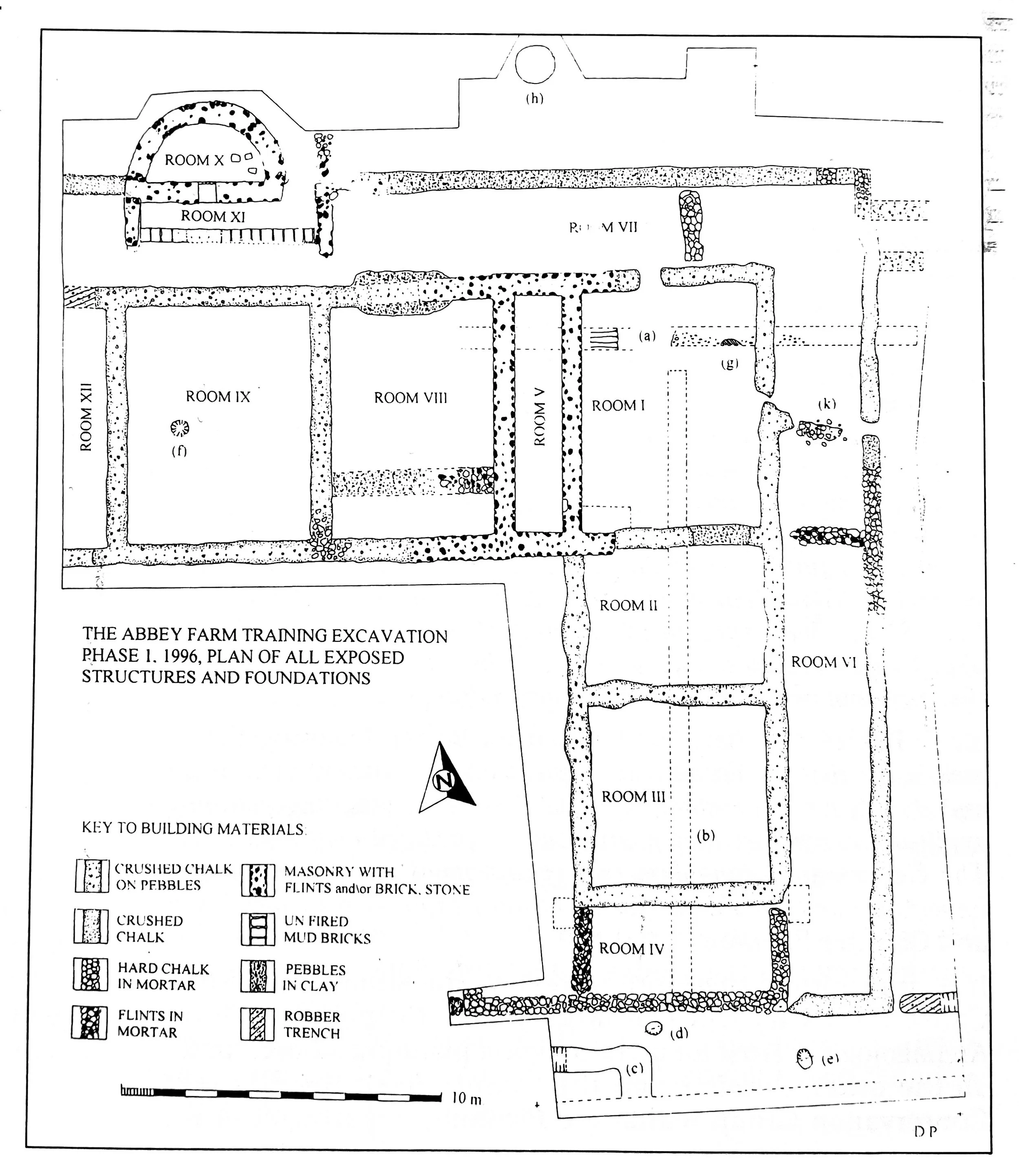
As can be seen from the plan, a variety of materials were used to construct foundation courses, and there is also variation in the depths to which these were cut. While it would be premature at this stage to draw firm conclusions, at least three phases of expansion and modification to the building seem indicated, perhaps culminating in the insertion of the Room V foundation, possibly the stairwell and load bearer for a tower or upper story.
The role and function of the complex constituted by Rooms X and XI is at present enigmatic. Room X, which has a stoke-hole and is floored and lined with opus signinum, would appear to be an hypocaust fed from Room XI, which has a floor of mortar at a lower level and a back wall of mud bricks laid in mortar. The complex does no� attach to the main range of the building, and appears to have been demolished to ground level before the east - west wall north of Room VII was built. Most of the finds of wall and floor mosaic and painted plaster were obtained from the demolition layers within these rooms.
In summary, the initial results of excavation indicate that the Abbey farm remains are those of a fairly large and well appointed villa. Although the east wing foundations have been heavily plough damaged, the results of trenching in 1991 suggested a better state of preservation to the west, with floors and hypocausts surviving under a deeper overburden. This gives rise to hope for the next phase of excavation, and is born out by a discovery made during the last week of access to the site. This consists of remains of a small building about seven metres square, situated about forty metres west north west of Room X. Trial trenching by volunteers has revealed wall courses of hard chalk, and an opus signinum floor framed by vertically set tile, these being protected by an overburden of about 0.40 m.
D.R. J. Perkins