Boley Hill, Rochester: Repaving Project
Over an eight-month period (April to November 1998), the Canterbury Archaeological Trust undertook observations and excavations over an extensive area to the west and south of Rochester Cathedral prior to a new cobbled road surface being laid. Thanks are extended to the then Rochester upon Medway Council for funding the archaeological work and to the many individuals involved who have given assistance before, during, and after the on-site work.
The archaeological work was undertaken in several separate phases as, and when, areas of the old road surface were stripped off. For most of the route, 45cm of material was removed, although deeper drains and soakaways also had to be inserted in restricted areas.
Adjacent to South Gate House in Boley Hill road, remains of the Roman South Gate, along with a short stretch of the town wall, was uncovered just 35cm below the modern road surface. Although the flanking walls to the gate passage can be definitely assigned to the Roman period, the actual defensive wall, of which two structural phases were visible, is harder to date (Ward 1998). This short article will concentrate on the archaeological remains that were found whilst work was undertaken in The Precinct and in front of the west end of the cathedral. At the time of writing, the archive report for this project is well in hand (Ward, In preparation a).
The Precinct
In its present form, the Prior's Gate probably dates from the early fifteenth century (Flight and Harrison 1986, p. 16; Tatton Brown 1998, p. 1). This gate was connected to an earlier defensive wall to both east and west. Part of this demolished wall was observed in front of Mackean House within the precinct and, surprisingly, two structural phases were identified (Plate 1). The foundation of the eastern 5.50m (of the 6.25m length) cut into the western portion and was angled southwards. This longer portion possibly forms the blocking of an entrance. A causeway across what is known as the King's Orchard Ditch had been previously postulated just to the south of this wall (Flight and Harrison 1986 p. 15) and, if such existed, would support the idea that an entrance existed at this point. However, the apparent lack of defensive arrangements, in the form of gatehouse or towers, may argue against an opening. The blocking of an entrance may have occurred at the time of construction, or more likely lengthening (59m in total length and 10.50m wide) of an earlier medieval building, most of which lies below Minor Canon Row.
 Plate 1. The town wall crossing the road in front of Mackean House, The Precinct. Note the kink, which shows that the wall was constructed in two phases.
The eastern end of this structure (Plate 2) had walls up to 1.25m wide made from chalk and ragstone rubble, whereas to the west, below the pavement in front of Minor Canon Row, the south wall consisted entirely of ragstone with a stone and flint facing (Plate 3). As chalk tends to be used later in the medieval period for the construction of walls, this disparity in material suggests the eastern portion of the structure was added onto an already long building. The only relevant dating evidence for the construction of this east end was a sherd of Flemish floor tile, which indicates a date to or after the late fourteenth century. Within the earlier ragstone rubble wall, a 1.50m wide doorway (Plate 3) provided architectural detail in the form of a 'long broach stop' which suggests a date of the mid-fourteenth century or later (personal communication Rupert Austin architectural draughtsman of C.A.T.).
 Plate 2. East end of the long medieval building being surveyed. A chalk lined post medieval cess pit can be seen in the foreground.
 Plate 3. The ragstone rubble south wall of the long building with side doorway and threshold. The floors of this structure will survive over a meter below the modern pavement.
It is possible that the ragstone rubble portion of this building is the 'long bakehouse' mentioned as being rebuilt from 1331 at the expense of Bishop Hamo of Hythe (Hope 1900, p.49, 52). If so, this structure may hold the key to our understanding of the development of the defenses of medieval Rochester (Ward, In preparation b.) The reader is directed to the article by Colin Flight and Arthur Harrison (1986) for more detail on the ideas regarding the defenses. In basic terms:
Scenario A (Harrison) envisages the Roman town wall remaining in use until c. 1344 with a deep medieval ditch (the Deanery Garden Ditch) being excavated in front c.1225. This line was abandoned c. 1344 and new defenses, of which the Prior's Gate (albeit a later rebuild) is the last remnant, were constructed. There was a further shift to the south in the late fourteenth century.
Scenario B (Flight) envisages a ditch (the Deanery Garden Ditch) being excavated in front of the Roman wall between c. 1070 and c. 1120. These defenses were replaced c. 1225 by the walls and/or a ditch (King's Orchard Ditch) on the line of the Prior's Gate Wall. In turn, these defenses were replaced c. 1344 by a wall further to the south.
The long building found was constructed directly over the infilled Deanery Garden Ditch. If this structure can be successfully equated with that rebuilt in 1331, then it must mean that the ditch was infilled before that date. Consequently, the defenses in line with the Prior's Gate (whether the gate was present or not) must be those which date to c. 1225. At present, the evidence from the long building is not conclusive, but there are several other factors which, when all are added together, suggest that Colin Flight's sequence (with refinements) is correct (Ward, In preparation b).
As the road stripping moved north towards the cathedral, it had to re-cross the line of the Roman defensive wall, a small segment of which was observed. More importantly, attached to the inside face at a right angle was a further wall, which appears to be the remains of another gate. The very distinctive yellow mortar that bonded this wall had a high concentration of broken seashells within its matrix and is regarded as being the same as that found bonding a building of Norman date found in the adjacent garden (No. 1 Prior's Gate House) in 1976-7 (Harrison and Williams 1979, p. 22). In 1986, Arthur Harrison had suggested that a gate would be found exactly at this point. While only a western wall was found, it seems more likely, due to the fact that it comes to an abrupt stop, that this is one side of a gate passage (Plate 4) rather than being a boundary wall around the Bishop's Palace.
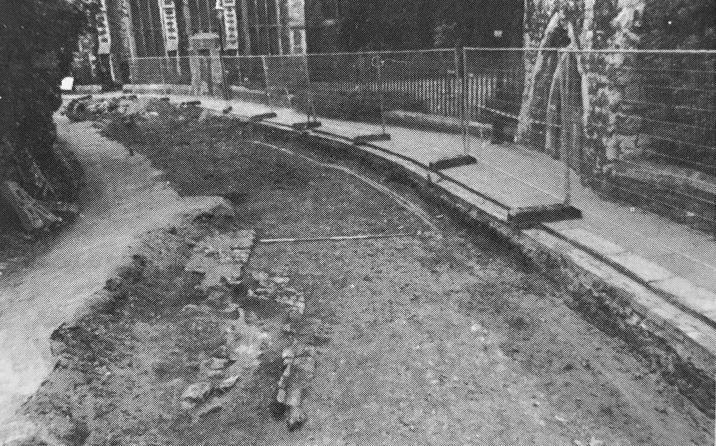 Plate 4. Roman town wall and (Norman?) gate passage wall to the rear.
The Anglo-Saxon Church
In front of the great west door of the cathedral and just 25cm below the modern road surface, the remains of the Anglo-Saxon church first discovered by Canon Grevile Livett in 1888 were uncovered (Livett 1889, p.261-8). In 1888, the west front of the cathedral was underpinned and a substantial part of the east end of this Anglo-Saxon building was therefore destroyed, although part of the apse, marked out just within the cathedral nave, probably survives.
In the width of the road, it was known that a deep Victorian drain trench was present and this was found to cut the north and south walls of the Anglo-Saxon structure (Plates 5 and 6). The observed sections of 1.25m wide wall (or rather foundation) varied between 0.75m and 1.50m long. Only the northeast portion produced an actual fragment of upstanding wall and this could be seen to have a slight curve on its inner face forming the beginning of the apse; part of this portion of wall was bonded by opus signinum concrete.
 Plate 5. The seventh-century Anglo-Saxon church from the cathedral roof. The fragment of wall in the bottom right-hand corner is part of the apse.
 Plate 6. Cleaning and recording the north wall of the Anglo-Saxon nave. Note that this wall and the apse wall have been cut by a Victorian drain trench.
This material is usually associated with Roman buildings but was also used in the seventh century churches built by Roman missionaries using classical building techniques. The latest use of this type of concrete known to the writer is at Jarrow in 681 (Cramp 1969, p.45-9). Although no Anglo-Saxon floors survived, it could be deduced that they would have been considerably higher than the later medieval and modern floor level within the cathedral.
This latter point has an interesting impact on masonry found by Livett immediately to the south of the southern foundation of the Anglo-Saxon church. Until now, the present writer had always regarded this masonry as forming a porticus or side chapel such as existed at known seventh-century churches at Bradwell (Essex), Reculver, and St. Pancras, Canterbury. However, analysis of Livett's text shows that the remains of the upstanding wall of this structure must be cut by the foundation of the south wall of the Anglo-Saxon church. Both the form of the Anglo-Saxon church, and the use of opus signinum, suggest that it is of seventh-century date. As no masonry buildings were constructed during the course of the fifth or sixth centuries, the structure cut by the church must date to between the late first and late fourth centuries; it must form part of a Roman building.
Furthermore, the level of the Anglo-Saxon floor surfaces in relation to the medieval floors of the cathedral suggests that substantial leveling of the ground surface took place when the Norman church was built. In 1898, William St. John Hope reported that a structure which he believed to be a larger Anglo-Saxon church had been found in 1876 while underpinning the south wall of the Norman nave (Hope 1898, p.214-5). As the floors of this building are below the floor levels of the medieval cathedral and over a meter below those of the Anglo-Saxon church, it must follow that the masonry and floors of this building are also of Roman date. These two areas of Roman masonry may form part of the same structure. Of the six or seven known Roman masonry structures within Rochester, this is the first identified as being to the east of the Boley Hill/Northgate road axis.
The above article is only a brief summary of what was found during the course of the repaving project. At the time of writing, full analysis of the information recovered has not been completed; the interpretations offered therefore have to be regarded as provisional and may be subject to revision.
References
Cramp, R. 1969. Excavations at the Saxon Monastic Sites of Wearmouth and Jarrow: an Interim Report, Medieval Archaeology, Vol.xiii, p.21-66
Flight, C. and Harrison, A. C. 1986. The Southern Defences of Medieval Rochester Archaeologia Cantiana, Vol.ciii, p. 1-26
Harrison, A.C. and Williams, D. 1979. Excavations at Prior's Gate House, Rochester 1976-77, Archaeologia Cantiana, Vol.xcv, p.19-36
Hope, W.H. St. John. 1898. The Architectural History of the Cathedral Church and Monastery of St. Andrew at Rochester, Archaeologia Cantiana, Vol.xxiii, p. 194-328.
Hope, W.H. St. John. 1900. The Architectural History of the Cathedral Church and Monastery of St. Andrew at Rochester, Archaeologia Cantiana, Vol.xxiv, p. 1-85.
Livett, G.M. 1889. Foundations of the Saxon Cathedral Church at Rochester, Archaeologia Cantiana, Vol.xviii, p.261-278.
Tatton Brown, T. 1997. The Prior's Gate Rochester Cathedral (unpublished assessment report).
Ward, A. 1996. Excavations at Rochester Cathedral 1990-1995 (unpublished archive report).
Ward, A. 1998. The Roman South Gate Rochester in Kent Archaeological Society Newsletter.
Ward, A. In preparation a: Archaeological Observations Undertaken During the Boley Hill Repaving Project (archive report).
Ward, A. In preparation b: The Archaeology and Defences of Rochester (archive report).
Alan Ward. Project manager, Canterbury Archaeological Trust. January 1999.