Observations on the supposed site of Ancient Roman Maidstone
By Beale Poste.
Many who read these pages will be doubtless aware that in fixing a determinate site for the Roman military station Vagnacae, I am assuming to do that which has never been attempted to be done by the old antiquaries, as Camden, Gale, Burton, Leland, or Lambarde; or by the moderns, as Gibson, Gough, Reynolds, Hasted, Thorpe, or Hatcher, or even been supposed by Newton himself, the learned historian of the place. This undoubtedly is so; for though a fair proportion of those eminent persons in the antiquarian department of literature may have thought generally that the Roman station was at Maidstone, yet none of them have advanced so far as to point out in what quarter of the present town the precise spot was situated. I must proceed therefore with some degree of caution on this hitherto untrodden ground: and as my reasoning on the subject will be purely inductive, it will be the most convenient way for me to arrange what I shall say under distinct heads or paragraphs, which I shall accordingly do as follows:-
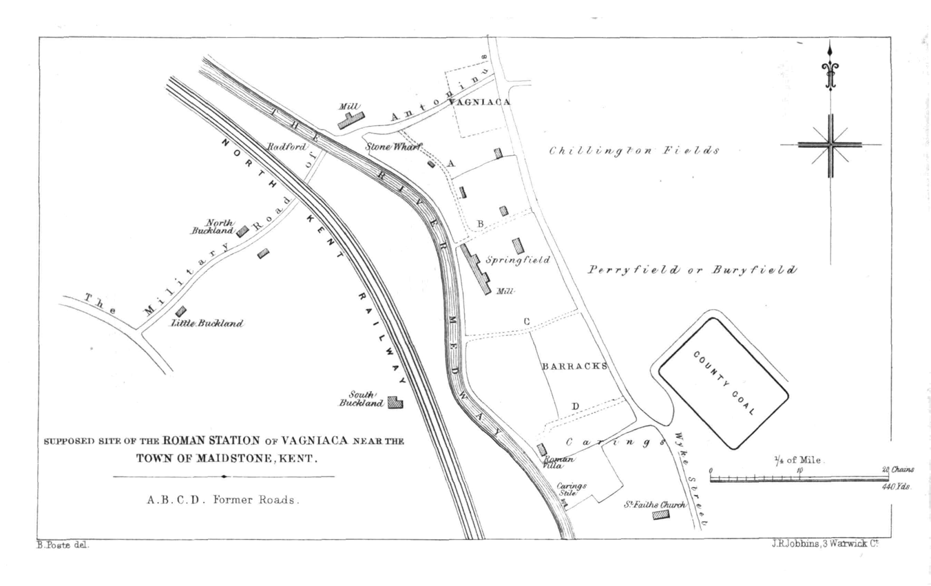
First, I must duly notify that the fact of its being in or about Maidstone at all, is derived from the 'Itinerary of Antoninus,' that ancient 'Guide des Voyageurs,' or 'Handbook for Travellers,' in the time of the Romans. It is said in it, that from Vagniacae to Durobrivis, or Rochester, is nine miles, that is, about eight English ones; and I conclude, in unison with various authorities on this behalf, that from the general bearing and direction of the places mentioned in the 'Itinerary,' there is very sufficient reason for supposing that the ancient Vagniacae was either in this town or in its vicinity. This point, however, I must assume, as the discussion of it would take me away from my present purpose, and might besides run into some length, both of which things are undesirable. Assuming this then, as I have said, I observe that the Roman road coming from London by Keston (Noviomagus), Oldbury Camp, and Wrotham Heath, crossed the river Medway near Maidstone, about half a mile below the present town, and rather more than a quarter of a mile below the barracks.
The part of the river where it crosses is called "Radford," which name shows that some thoroughfare of importance formerly existed at this said passage of the river; for Radford is Roadford. The name of the reach of the river across which the ancient transit was made, indicates the same thing. In the Corporation Books of Maidstone, of the date of Queen Elizabeth, it is called "the Throt Reach;" in relation to which we may observe that there is no narrowness of the river at this point to make us suppose "Throat Reach," in the sense of a narrow passage of its channel, was meant. So this appellation seems to be the same as the Anglo-Saxon trod, a path or track, and to denote the reach where the crossing was; which it is very natural to suppose had become in their times of less importance. The reach of the river at this part still retains its Elizabethan name: and a wharf on the east side of the river, at the point of crossing, belonging to the Earl of Aylesford, is known by the designation of the "Throt Wharf." It is certain that the river at Radford is not now a ford, being deep water; but as it was anciently named a ford, we may disregard this, and conclude that it has been either deepened by art, under the Lower Medway Navigation Act, or that the bottom of the river at this part may have been acted upon by the current. There is thus a good and fair argument that the name of the "Road-Reach" was given to a particular part of the Medway by way of distinction, to show where the once important Roman military road passed this river.
It perhaps should be mentioned, in reference to the Roman road coming from Wrotham Heath to Radford, that a quarter of a mile before it reaches the river, it passes the foundations of an apparently extensive Roman villa, which was placed on a species of terrace to the right. These foundations are in a cherry-orchard, on the farm of Little Buckland, the property of Mrs. Seabrook. The neighbouring cottagers report that they formed a great obstruction when the orchard was planted, now about twenty-three years since. Roman coins are stated to be found in the vicinity. It may also be noted, that about three-quarters of a mile north-by-west from the ancient Radford ford, towards Allington, foundations of another Roman villa were removed in 1844 (see the 'Journal of the British Archaeological Association,' for 1847, vol. ii. p. 88). To continue however with the road on the north side of the river.
When the road has crossed at Radford, it ascends the gradually rising ground for three or four hundred yards, and having reached a species of plateau, or level, it joins nearly at right-angles the ancient Roman road, proceeding in one direction to Rochester (the Durobrivis of Roman times), and in the contrary direction communicating with the Weald of Kent. The said Durobrivis, it may here be remarked, was also a Roman station, and one of the more important class.
I venture to place Vagniacae at the junction of the two roads of which I have just spoken. I cannot assign its precise dimensions, but were it entrenched, we may suppose, for the sake of entertaining a definite idea on the subject, that it comprised some three or four acres. However, were it a Roman station of the smaller kind, one of those which were styled not so much a "station," as a "mutatio," or "mansio," it need not in that case have been necessarily entrenched; nevertheless the greater probability is that it was: but be this as it may, and considering the Roman station as the head-quarters, I conclude that the Roman town or settlement connected with it lay still further to the right, that is, to the south-east, and extended along the somewhat high ridge, parallel with the river, towards the present town, to the distance of more than a quarter of a mile in that direction.
There are no reliable appearances of embankments at the spot now assigned for the station, though there are certainly some inequalities of the ground behind the dwelling-house, the property of Dr. Lowdell, M.D., which at present forms the last building in Maidstone parish in this direction. All confidence, however, in any supposed configuration of the surface, is lost, from the following cause.
The ridge I have spoken of, extending parallel with the river, has every appearance of having been the spot from which stone was procured, in the Middle Ages, for the public buildings in Maidstone, and as having formed the supply whence St. Faith's church, that of All Saints, as also the building of the Fraternity of Corpus Christi; the palace, Newark, the bridge, and, it might be, other buildings, were constructed. Excavations and hollows, made formerly for quarrying purposes, meet the eye in every direction. The archbishops had evidently chosen the other end of Maidstone for embellishment, and seem to have found their materials here; and with the disturbing the surface and ransacking the earth for its stony treasures, the traces of Roman buildings would of course vanish, and render the site of the ancient town impossible to be identified. As far as we know, all traces of Roman occupation must have been removed anterior to the time of Leland and Camden, and much more of course before the date of Newton the historian of the place, and the later antiquaries. We have record evidence, the best perhaps that can be adduced, that the quarries at this spot were in full activity in the fifth year of Henry V. (1418). In that year the following entry occurs in Rymer's 'Foedera,' as quoted by Brayley in his 'Delineations of Kent,' p. 1278, being an order from the Crown for stone cannon-balls, addressed to John Louth and John Bennet, masons at Maidstone:- "Septem millia lapidum pro gunnis de diversis sortibus, una cum sufficienti stufferia lapidum pro eisdem, tam infra quarreras de Madeston hithe, quam alibi." That is, "Seven thousand stones for cannon of different kinds, and a sufficient supply of stones for them in the quarries at Maidstone Hythe, as well as elsewhere." Hythe Street, in Maidstone, was the ancient name of that part of the town, on the east bank of the river, which is now called "Water-side." To this the said quarries would be contiguous, and hence all this large tract of excavations, to which the removal of ancient foundations and remains is attributable, appears to have received its name.
There being thus no foundations or other remains to which we might refer, our research must be continued from collateral indications. Proceeding then by this path, it may be observed that we have a considerable tract of land in this very angle and portion of Maidstone parish, designated in ancient deeds as "Perryfield." This is mentioned in the Crown Leases in the Augmentation Office (see Hasted's 'History of Kent,' vol. ii. p. 160, and compare also the 'Ministers' Accounts' for 1543, as in Ellis's 'Dugdale's Monasticon,' vol. v. p. 462). It is stated, in the Crown Leases referred to by Hasted, as comprising forty acres, but there is little doubt that, according to the customary difference in these old measurements, it contained above sixty; and, in short, it is believed that a great part of the whole north-western angle of this part of the parish abutting to Boxley, north-east of the Rochester road, was in it; and possibly it might have extended to the south-west of the same. In any case, it lay contiguous to our station of Vagniacae. Now in Kent, as indeed in other parts of the kingdom, Perryfield is identical with Buryfield, and means a place where is, or has been, an old fortification. Thus, among numerous other instances, there is an ancient earthwork in Perry-wood, in the parish of Selling, near Faversham, and it seems to be understood as a matter of course that our Perryfield should more properly be Buryfield, from the Anglo-Saxon byrig, an entrenched place, and that it implies the vicinity of a fortification. But what fortification? None was ever known to exist in that quarter of the parish; and what other explanation of the fact can there be, except that the appellation arose from our lost Roman fortified station, described in our former page as situated at the junction of the three roads, and which we may believe to have yielded to the vigorous quarrying efforts made by the archbishops for the embellishment of the town in the Middle Ages.
Having thus shown the probable spot of the Roman station Vagniacae, I now proceed to offer an observation or two on the supposed site of such town or village as the Romans may be thought to have had at ancient Maidstone. I place this, the reader will recollect, together with the station, on the ridge before mentioned, but extending towards the present town to the south-east, and in fact abutting on the Government property now occupied as barracks in that direction. The whole space thus assigned to the station and to the first rudiments of the town, taking the present high-road to Rochester for a boundary on one side, and the river for a boundary to the other, includes an area of ground averaging about 616 yards in length, by 264 in breadth, and comprising in superficial measure, according to Mr. Brown's Survey of the Parish, in 1822, 34a. 0r. 35p.; the whole of which, except Dr. Lowdell's house, garden, and field, is the property of Messrs. Balston, and is called the Springfield Estate and Paper-mill, and on it stands the handsome mansion of the proprietors. Here then apparently was the original Roman settlement, which there is no reason to suppose was one which was formed on a large scale, but only to have been sufficient for the casual contingencies of ancient travelling and of the transit of troops. No one, indeed, entertains the opinion, however flourishing the place may now be, that there was ever a Roman town of magnitude here. We freely admit that there was some germ in existence then, some nucleus of the future town, which has since been so much developed; and this forms a commencing-point for the portion of our subject now under consideration. It seems therefore much connected with our present inquiries, to show the progressive increase of the town and borough, from its small beginning at the original Roman "station," until it attained its present dimensions. In doing this, it must be understood that the archbishops, who were lords of the soil and had the chief sway and domination here from Saxon times, were the prime movers in all improvements in the place, down to the beginning of the fifteenth century; and having premised this, my ensuing remarks, or a portion of them, will have somewhat of a chronological scope in tracing these matters downwards.
The ancient local divisions of the parish which are still retained, have a bearing on the progressive increase of the town through various ages. These divisions are called "boroughs," and, if we understand rightly, are as old as the time of Alfred; having been connected, as we may conclude, with his distributing various districts into communities, the members of which entered into a pledge among themselves to keep the peace, and to prevent the laws from being broken; and, indeed, hence the legal manorial form, styled "View of Frankpledge," which is still observed, is derived. The four of these ancient divisions into which the parish of Maidstone is apportioned, are as follows, viz. the borough of Wyke, the borough of Maidstone, the borough of Stone, and the borough of Westree. It is singular in these, that we have the borough of Wyke mentioned as distinct from the borough of Maidstone. However, the earliest reference to them I can find is in the Manor Book of Maidstone parish for the years 1510 and 1511, No. 1025, in the Lambeth Library; in the latter of which years we have Wyke, Maidstone, and Stone mentioned, but from some cause Westree is omitted, which is not material. We have then this fact, that this part of the parish was in Alfred's time called the "Wyke," to obtain which name there must have been an ancient "vicus," that is, village or town, of the Romans at the spot; for it is not to be believed that the Saxons ever gave the name, except in reference to the Latin term vicus, before existing at the place.
The name of the street, "Week Street," extending from this quarter (I mean, from the assigned spot of the station), nearly a mile to the south-east, is also in point. This street, in its course to the south-east, gave name to the Manor of Wyke, which is somewhat remote from the supposed site of our Roman station; and if the said Manor Rental of 1511, to which I have just referred, be understood rightly, was not in the borough of Wyke: as will be further shown presently. In the meantime it may be observed that there is a similar case in another of the minor manors of Maidstone, that of the "Manor of East Lane," which takes its name from the street in which it happens to be situated. The fact of this Manor of Wyke not being in the Borough of Wyke is so far material, as it does not interfere with the location which has been here otherwise assigned to the Roman "station" and "vicus," or first settlement, at Maidstone; and here therefore is a point much connected with our subject. As to what is known of it: it was, then, a manorial estate in Maidstone parish, held under the archbishops as a portion of the principal manor which they possessed in the place. A somewhat high and strongly-built wall still remaining in Union Street, in the lower part of it, and near where it makes its junction with Week Street, is believed to have been the garden-wall of the manor-house. It is just above the hardware-shop of Mr. Gilbert, and another house occupied also as a shop at the corner of the street. The Mansion House itself, the property of John C. Stephens, Esq., still stands in Week Street, but is divided into two or three dwelling-houses, and its ancient character has been entirely removed by modern frontages. The Fishers, a family well known in Maidstone, held the estate at least for a hundred years, and it is not accurately known how much longer. Their name appears in the manor survey of 1511, before referred to, as then holding it; where the lands of William Fisher are charged with the manorial rent of 46s. and 2d., as under the division of Wyke Street, and not as in the borough of Wyke-which is the entry affording the proof to which allusion has before been made. It so happens that among the manuscripts of the British Museum, No. 2192-4 of the Harleian Collection, an ancient rental is preserved, not dated, but apparently of about the time of Elizabeth, bearing the title of 'A Survey of the Manor of Wyke.' By this, as far as the various fields can be identified, they seem to have extended northward, commencing in a line with the present Union Street, and comprised 245a. 2r. 31p. A considerable portion of the lands has been purchased of late years by Alexander Randall, Esq., who has an elegant mansion on the property, in which he resides. The Fisher family ultimately conveyed the estate to the Company of Merchant Tailors, in the year 1617.
I may add also another feature to these remarks on the site of our supposed Roman station and settlement, or Roman station and "vicus," as we may now call it, that various ancient roads appear to converge to it; and not so much to the present town of Maidstone, as it now lies situated more to the south-east. For instance, one remarkable one coming over the Boxley range of hills near the farm called Boarley; much scooped out of the side of the hill, and therefore very conspicuous. There is likewise another instance in the old Sittingbourne road, which formerly pointed hitherward; though now it is much altered at the Maidstone end. An ancient carriage-road likewise communicated direct with the spot I have assigned for the Roman station, from Boxley, coming partially through Mr. Lushington's lands. This gives a third instance of ancient roads converging to this centre. It joined it pretty much in a straight line with the road crossing the Medway at Radford, and coming up from the Throt Wharf, as mentioned in the former part of these remarks. This said ancient road is marked on the older maps of the Earl of Aylesford's estates, but is now completely discontinued; having been stopped up thirty or forty years ago, by the former Earl, at one end, and by Sir Henry Calder, Bart., a former possessor of Park House, at the other.
In regard to evidence from Roman and Anglo-Saxon remains, though somewhat of a negative character, it is on the whole favourable in its results to the views which have been advanced in the foregoing pages. No Roman foundations have been discovered within the limits of the present town, though we have indeed one instance, at the end which lies somewhat contiguous to the spot assigned to the Roman station and "vicus," of which mention will be made presently more particularly. Indeed, it has almost passed into a matter of course to consider that when deep sewers are dug in the streets, or other excavations made, none will be met with. It is probable then, as the whole tract was known to have been comprised anciently within the limits of the Weald of Kent, that in the time of the Romans much of the actual site of the town was a deep and secluded part of the forest, too densely covered with wood and thickets to supply proper localities for Roman villas. The other objects which are found are chiefly urns and coins. Very many years ago some of the former were found in digging the foundation of a warehouse in the angle between Earl Street and Pudding Lane, north of the latter. (See Newton's 'History of Maidstone,' p. 6.) A small urn or two were likewise found about eight years since, while excavating for a building in St. Faith's Street, opposite to the top of what was the former Green. Likewise, about twenty years before the said period, a few small urns, like the former ones of a black colour, and now deposited in the Charles Museum, were found in digging foundations four or five houses higher up the street on the same side.
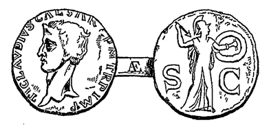
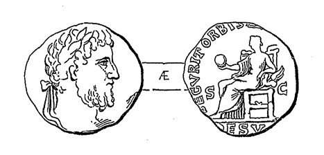
Of coins, a second brass of Claudius was found in the sewerage-cutting at the top of King's Street, about the year 1851. On the obverse it has the head of the emperor looking to the left, with the inscription, TI. CLAVDIVS CAESAR AVG. TRP. IMP., and on the reverse, Minerva to the right, poising a spear; inscription in the field, s. c. A first brass of Commodus was found, as said, four feet from the surface in All Saints' churchyard in 1844, and is engraved in the 'History of the College of Maidstone,' p. 137, as also here represented.
A rather well-preserved denarius of the Emperor Trajan is similarly said to have been found in the bed of the river Lenn, about twenty-five years ago. The two last form part of the late Mr. Charles's Museum, now belonging to the town of Maidstone. A third brass of Constans, with the delineation of the Labarum, was found at the top of Stone Street, on the left hand, on what was formerly called "Sayer's Land." A Roman consular coin, of the family of Accoleia, was found in the present year in one of the gardens of Medway Street, inscribed with the legend, P. ACCOLEIVS LARISCOLVS. Likewise about the same time a denarius of the Emperor Julian was found in or about Maidstone, inscribed on the obverse, FL. CL. IVLIANVS PP. AVG.; on the reverse, VICTORIA. DD. NN. AVG.; and in the exergue, LVG. The coin is in very good preservation. Of other objects, a statuette of Mercury was found thirty years since in Mr. Lamprey's grounds, on the Boxley road, about a quarter of a mile out of Maidstone, now in possession of Captain Skinner, R.M., his nephew. Likewise another bronze statuette of Sylvanus, as delineated in the margin, was dug up about the year 1820, in the borough of Westree, Maidstone, across the bridge.
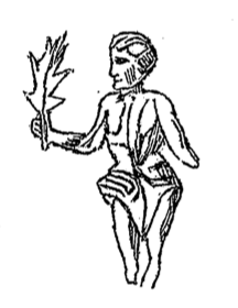
It was formerly in possession of Mr. Lamprey, and now of Captain Skinner, as the preceding, and is only two inches in height. Also in the year 1823 various sepulchral antiquities, apparently chiefly Anglo-Saxon, were discovered in Wheeler Street, in excavating for laying the foundations of the Lancastrian School. These few dispersed relics show no sufficient indications of either a Roman station or town where the present town of Maidstone stands. They are scarcely more than might be expected from digging to the same extent in the New Forest, or in that of Epping: While in the direction of that part now out of the present town, or on the skirts of it, which I have suggested as a far more favourable sphere of inquiry, we have something much more relative. There are in this quarter the foundations of the large and substantial Roman villa or building partly excavated by the late Mr. Charles; which will be more fully described in a subsequent paragraph. In the meanwhile, more completely to show that the first Roman establishments were in that quarter and on that spot with which I have endeavoured to identify them, a few words on the gradual rise and extension of the town of Maidstone, from the said locality, may probably not be here irrelevant.
Whatever may have been the state of the site of the present town of Maidstone in Roman times, whether it were forest or under any species of cultivation, it is certain that a Roman road went through it, in its progress to the Weald of Kent. This road has been mentioned before (see the previous page 156), and it seems that after it went further on, it divided into two branches, at about a mile and three-quarters from the site of the present town, both of which terminated in about four miles in an ancient road, called the "Chartway," which went for some very considerable distance along the outskirts of the said district of the Weald. A road to the Weald, then, passed through the site of the present town; and besides that, as before mentioned, the military road of Antoninus, coming from London, by Keston, Wrotham Heath, etc., crossed here at Radford in its way to Durobrivis, Judd Hill (i. e. Durolevum), and Canterbury. These are almost the only two facts now known of the earlier state of the town. It was, as is supposed, about the year 800, in the time of the Saxon kings, that the whole parish was transferred into the hands of the Archbishops of Canterbury, by some unknown donor, neither the original grant or instrument, nor any notification of its contents, being now extant among the records of Canterbury cathedral, or elsewhere; but what is our argument from this? Why, it may be inferred that if the lands granted by the donation were so large in extent as they undoubtedly were, that they must have been deficient in population and comparatively uncultivated. There having been originally a Roman station here, and contiguous to it a Roman settlement, or "vicus," it would seem that dwellings became gradually constructed under the archbishops, on the line of Roman road, which was the more promoted by its being a thoroughfare, as has just been said, from the Weald of Kent; but so gradual was the progress of this now important town, that it can scarce be found mentioned in our national records till the thirteenth century. In that century, in the year 1261, Archbishop Boniface, the founder of the Hospital of Newark, which is situated across the river, on the former London road, obtained the grant of a market at Petrisfield (see the 'History of the College of Maidstone,' p. 109), which if it occupied the spot where the present High Street of Maidstone now stands, the former known and accustomed place of market, it must have been an expedient to draw population towards his new foundation, as also towards the dwelling of the archbishops. They, since the reign of King John, had resided in the house that had belonged to William de Cornehill (see Philipot's 'Villare Cantianum,' p. 228), which had been granted to the See of Canterbury; the same having been re-edified by them, and having acquired the name of a palace. In 1272, being the first of Edward I., the Church of St. Faith was completed, as appeared by an inscription on one of the pillars so read. It stood about a hundred yards due west of Week Street, and is believed to have been the prolongation of a former building, built about forty years previously. In 1422, as appears by the deed of endowment still in existence, the Brotherhood Hall was founded by John Hyssenden, otherwise called Nayler, an inhabitant of Maidstone, at the bottom of Earl's Street, near the river; and thus the fraternity, called the "Fraternity of Corpus Christi," was established. This was no other than an early rudiment of the Maidstone corporation; for the elders of the town were the principal members of this religious foundation, and this building was the quasi- 'Town Hall' of their day. Here observe, that as in London the magistracy has from the first continued to be in that part where was the ancient Roman city, so in the case of this our county-town of Kent, the seat of municipal government still lingered towards that quarter in which the place had first sprung up; and it seems to have done so for more than a century and a half afterwards. There was at this time a chapel, named St. John's chapel, just over the bridge of the Lenn, and a church, named St. Mary's church, standing near to the archbishop's palace, to the south. This must have been subordinate to the church of St. Faith, which has been removed in the present year (1858), and which was situated towards the ancient site of the station and "vicus" before described, though without their limits, and which doubtless was the church of the place mentioned in the Domesday survey of William the Conqueror. Nearer still to the station and "vicus" was the chapel of St. Anne, which, according to 'Inrolments' in the Augmentation Office (cited by Hasted in his 'History of Kent,' vol. ii., folio edition, p. 106), adjoined Perryfield, and might have been in close proximity to the "vicus;" but its exact site is not precisely known.
Archbishop Courtney, however, completed the plan which appears to have been entertained by his predecessors, of forming the town in its present site, by founding and building a college, and a new and magnificent church in this quarter, dedicated to All Saints. Both these works seem to have been completed shortly after his death, in or about the year 1400. There is also great probability that he formed some of the buildings in the High Street, as Leland, in his 'Itinerary,' vol. vi. p. 2, says that, "besides at the palace" (and college and church he might have added), "Courtney builded much in Maidstone." The High Street is believed to have been in existence as a street in the days of Courtney, as the Swan Inn, now added to the premises of Mr. Warwick, and occupied by Messrs. Paine, Evenden, and Lewis, is mentioned in a deed of a date not long subsequent to his time. Nevertheless, though there was this progression, the principal houses and dwellings for long afterwards seem to have been in the two original streets, those of Wyke and Stone Street; for Leland, the eminent antiquary, travelling through the town in 1525, describes it, in a continuation of the passage before referred to, as "one long street, full of inns." He did not, then, find the High Street important enough to be mentioned: it possibly was not more than a mere market-field. This now handsome street, the High Street, might then have been, and probably was, like the ancient Smithfield in London, now abolished, encumbered with cattle-stalls and sheep-pens. Add to this, the main thoroughfare to London passed at that time by Rochester, so that the road over the bridge was not at that period much frequented. The bridge itself powerfully bears testimony to this, and shows the progressive increase of traffic in this quarter, since, when viewed from underneath, the original structure hardly seems to have been of more importance than might have been expected to have been met with in some small country village over a river. It plainly appears that it was at first only constructed for the passage of one vehicle at a time. Afterwards, anciently, but still at some unknown date, it was widened for two carriages to pass each other; while subsequently again, in the year 1808, eight feet of breadth were added to it, which dilated it to its present dimensions.
I have now to revert to the large Roman building, or villa, discovered not far from the limits of our supposed Roman first settlement in these parts, and marked on the map. The spot is called "the Mount," in an old deed, and stands on a prominence or rising of the ground, some twenty-five feet above the present level of the river, which, as the bed of the river itself is known to have been raised about twenty feet since Roman times, was of course once considerably more elevated than it is now. The discovery of the villa was recorded in the 'Journal of the British Archaeological Association,' vol. ii. for 1847, pp. 86, 87, 88, and a plan added. The part excavated by Mr. Charles measured, the front forty-two feet, and the side, including the part visible beyond the modern wall, about eighty-six feet. It may be therefore concluded that the whole front would have extended to about one hundred and twenty feet, at least. There were no signs of hypocausts, i.e. of the furnaces used by the Romans for heating apartments, or of any other apparatus for that purpose. The inference thus is, that this part was merely used as inferior offices, and that the parts not excavated contained the rooms of an ornamental description: and it is noticeable that a fountain of beautifully clear water rising just above, at the front door of an ornamental cottage standing on the barrack property, built some twenty or thirty years ago by Lieutenant-Colonel, afterwards Brigadier-General, Skene, had undoubtedly formerly its exit through this unexcavated part of the villa, where it may be concluded it formed the impluvium. The walls were not above the usual thickness of those of Roman villas, being, the majority of them, about two feet, though one of the intermediate walls was nearly two feet six. But the most remarkable thing of the whole was the preposterous size and thickness of the buttresses, which some seemed inclined to think were not buttresses, but bases for pedestals of statues. Mr. Pretty, the learned curator of the Charles Museum, Maidstone, has favoured me with the remark that there is an occasional occurrence of large edifices in Zucharelli's pictures of the scenery and buildings of Italy, where ancient structures are introduced, not strictly castles or fortresses, but constructed with large buttresses, of what might almost be termed extravagant dimensions, placed at intervals along the walls, and thus seeming distinct from the usual class of domestic residences. He therefore thought that there was thus a coincidence in this circumstance in the villa discovered at this spot, and considered that there was probably here a public building of some sort. Mr. Pretty's views are ostensibly correct, but the small part excavated does not allow us to assign its supposed use. A few implements of Roman workmanship were found, fragments of personal ornaments, etc., and a copper coin of Gordianus III., who reigned from the year 238 to 244. I may add, that this building stood not on the tract of land called Perryfield, otherwise Buryfield, but on the adjoining piece, which anciently had the name of Carings, Charinge, or Charinges. It is mentioned in the 'Manor Survey' of 1511 as belonging to the Archbishop of Canterbury; as also in Sir T. Wyat's exchange with the king in 1540, where it is described as having been late the property of the abbot and convent of Boxley. It is mentioned also in a grant from the Crown to Sir Walter Hendley, where it is described as comprising sixteen acres, but without doubt was of very much greater extent. It had a yearly fair upon it according to the first deed, which is the more singular as showing that this quarter, now remote from the present town, had its own ancient fair. Its boundary towards Maidstone was a stile by the river's side, which appears to have stood about ninety or a hundred yards higher up the stream than our villa, and was called "Caring's Stile," whence it is considered to have extended to the north-west, and to have included the barracks; but how much further it went is perhaps uncertain. The fair held here does not appear to have been the same as that which is still continued in the Fair Meadow; as the last-named field, the proper appellation of which is handed down as the "King's Mead," is understood to have been in the possession of the town in the reign of Edward IV., and consequently long before the dissolution of Boxley Abbey, or of the exchanges which took place between the Archbishop and the Crown. Caring's Stile, I may add, is often mentioned in the corporation books of some centuries back, where it is put as a species of antithesis to the College Lock, about half a mile higher up the river; between which limits strict rules were enacted for the preservation of the fish.
It will be seen by the preceding details, that Roman villas stood pretty thick together on this side of Maidstone: one here at the Mount; another at Little Buckland (see before, p. 156); another towards Allington (ibid.); to these may be added one more near Barming church, and a further one at a place called West Town, in East Farleigh: these were all in a space of ground not more than two miles square. Now it cannot but strike us that Roman villas being so frequent in this locality, must needs be an indication of the proximity of a Roman station; while at the same time the other side of Maidstone by no means supplies the same results, where there are none. Doubtless the reason might be, that where the villas are, as well as having the advantage of the ford of Radford, the country was more open; and that where the present town now is, and in that direction, the forests, thickets, and underwoods were closer and more embarrassing.
I have thus offered my views respecting the Roman station of Vagniacre; the reader, however, must remember that there was a second station of that name, a second Vagniacre, at Aylesford; for in regard to the Roman military road which I have before described (see p. 155, ante) as coming from London by Keston, Oldbury Camp, and Wrotham Heath, it divided into two branches after having passed the heath some three or four miles; whereof one branch crossed the Medway at Radford, close by Maidstone, as I have endeavoured to set forth, the other passed over at Aylesford, and continued a separate course a mile or two from the river till it entered the Roman station at Rochester, near where the castle now stands. It will be observed that Antoninus, in his 'Itinerary,' has the name of our station "Vagniacre," in the plural number, by which a double station might be understood, and that he does not express it "Vagniaca," which would imply more particularly a single station. One manuscript copy of Antoninus has "From Vagniacre to Durobrivis VI (miles)," which probably is no mistake, but would be correct for the shorter distance which Aylesford is necessarily to Durobrivis. There is every reason to form an opinion that the Romans crossed at Maidstone or Aylesford as the tide suited, or as the floods of the river allowed, for no Roman bridge at either place is ever supposed; fords only, as the ancient names show, viz. Aylesford and Radford. Numerous objects of antiquity, British and Roman, were found, in the year 1824, at the ford at Aylesford, on the shoal there; supposed to have been lost in ancient times by persons who passed through the river, and some of them are now in the Maidstone Museum; but Radford, near Maidstone, as before observed, has no ford there at present. I must now leave these pages to the favourable auspices of those who may read them. Whatever may be the merit or demerit, I alone am answerable for these views; but it perhaps may be as well that something definite should be set forth on the subject, and I suspect that the researches of others will rather tend to confirm my conclusions than otherwise. At any rate, I have endeavoured to place the subject of ancient Roman Maidstone on a tangible basis, and if my ideas on its features prove correct, it will afford an answer to the question which is no doubt occasionally asked among the inhabitants, of the whereabouts of the Roman station and original settlement at this now flourishing county-town.
I should not omit to add that the accompanying plan of the station Vagniacre will show many details of its situation, and of that of some adjoining places which have been mentioned in these pages.
A few lines may be perhaps usefully bestowed to show briefly the reasons for placing the station Vagniacre at Maidstone: or, as said before, the portion of the double station so called, the name being in the plural number.
According to the Itinerary of Antoninus (Iter ii), Vagniacre, under whatever form it may have been, whether divided or single, should be the first station from Durobrivro on the road to London: and though it is conceded that there is a Roman road from Durobrivro, or Rochester, through Southfleet, Dartford, Welling, and Deptford to London, yet it is believed, from the impediment of three formerly considerable estuaries or arms of the Thames which crossed this line of road, that the transit in this direction must have been somewhat difficult. There are certainly no recognized Roman bridges or embankments over them. It is therefore inferred from this circumstance that the usual main line of communication for the Roman legions with their baggage and encumbrances was from Durobrivro, or Rochester, through Maidstone or Aylesford, as the tide might suit, and thence onwards through Oldbury camp and Keston to London. Agreeably to this idea the line by Southfleet and Deptford was only formed as a summer road, as some Roman roads are known to have been in Germany, for the transit and despatch of couriers and light troops in cases of emergency; who might have passed by means of boats. Thus Antoninus, in his Iters ii, iii, and iv, gives two distances respectively between London and Durobrivro for the two lines of road, namely, xxvii miles for the summer road, that over the estuaries, which is correct, and xxxvii (xlii) for the other.
The above is very much corroborated, and indeed almost rendered impossible to be doubted, from the statement in Antoninus that the Roman military road passed through or by Noviomagus (Keston), which place the road by Southfleet, Dartford, Welling, and Deptford leaves far away, many miles over hill and dale, to the south.