Archaeological Investigations at Maydensole, Near Dover 1996-1999
Introduction
Since 1996 an integrated programme of archaeological field survey and excavation has been undertaken across a sample section of the North Downs dip slope, about two kilometres north-east of Whitfield, near Dover.
Air photographs have revealed that the North Downs across this area was intensively occupied during the late prehistoric and Roman periods, evidenced by such features as enclosures, trackways, field systems and ring-ditches, representing a dense, widespread pattern of both nucleated and dispersed multi-period settlement. Few of these rural settlement sites have been subject to archaeological excavation. Fewer still have been subject to detailed field survey and study within their geographic context. The present work has been carried out with the objective of examining in detail the landscape setting, morphology, date and character of one of these settlements. The work has also been undertaken with a view to placing the results within a wider regional framework whilst, at the same time, endeavouring to further understanding of the pattern and development of rural settlement within east Kent between the Late Iron Age and Roman periods. The fieldwork was undertaken with the cooperation of the landowner and the enthusiastic assistance of the Dover Archaeological Group, led by Keith Parfitt, who carried out the greater part of the excavation.
The archaeological investigations presently described have focused on a well-defined sample group of air photographic features located immediately north of Maydensole Farm and have consisted of an initial phase of non-invasive field survey, followed by evaluation and limited open area excavation. The air photographic evidence for early settlement north of Maydensole Farm (centred on TR 31404795) consists principally of enclosures, tracks and field systems.
 Fig. 1 Location of Maydensole Farm showing air photographic features.
Taken together these form a large, complex settlement 1 Letterbox Field 2 Top Field 3 Cottage Field Maydensole Farm Fig. 1 Location of Maydensole Farm showing air photographic features occupying an area of over 12ha located across the ridge and south-facing slopes of one of the many east-west valleys which here combine to form the characteristic rolling chalk Downland landscape.
To place the site within its modern setting, the features can be seen to extend across Letterbox Field and Top Field, to the northwest of Maydensole Farm, and Cottage Field to the northeast (Fig 1). Although to date the investigations have concentrated on these settlement features the air photographs record other equally substantial settlements in the locality, but of different character and possibly, date, as at Broome Bungalows to the north. Cutting across the grain of the landscape is the former alignment of the Roman via strata connecting Portus Dubris (Dover) to Rutupaie (Richborough), now delineated in part by the present alignment of the lane known as Roman Road. From a point on the northern ridge of the valley, immediately to the north of the settlement at Maydensole, there is a clear panoramic view encompassing both of these major Roman military centres.
Previous Discoveries
Prior to the commencement of the recent investigations the area to the north of Maydensole Farm had produced a few archaeological finds indicating that the settlement was occupied during the Roman period. The earliest documented finds are those made by Captain Charles Newington, whose field notebooks record details of an early Roman cremation burial found in February 1911 just north of Maydensole Farm. The burial group, consisting of a cinerary urn and accessory vessels, including two Samian ware dishes, was found by workmen during the cutting of trenches for a new water main along the line of Roman Road just north of Maydensole Farm (Payne 1911, lxxxiii). At the same time, during a frosty early morning site visit, Newington observed and sketched a regular pattern of linear features visible as Plate I: Roman settlement immediately north of Maydensole Farm visible as air photographic features. The modern lane forming the eastern field boundary marks the alignment of the former Roman road (source: NMK908/202 dated 2.3.76). Numbers 1 and 2 mark the rectangular enclosures, numbers 3 and 4 mark the positions of the large anomalous features identified for investigation.
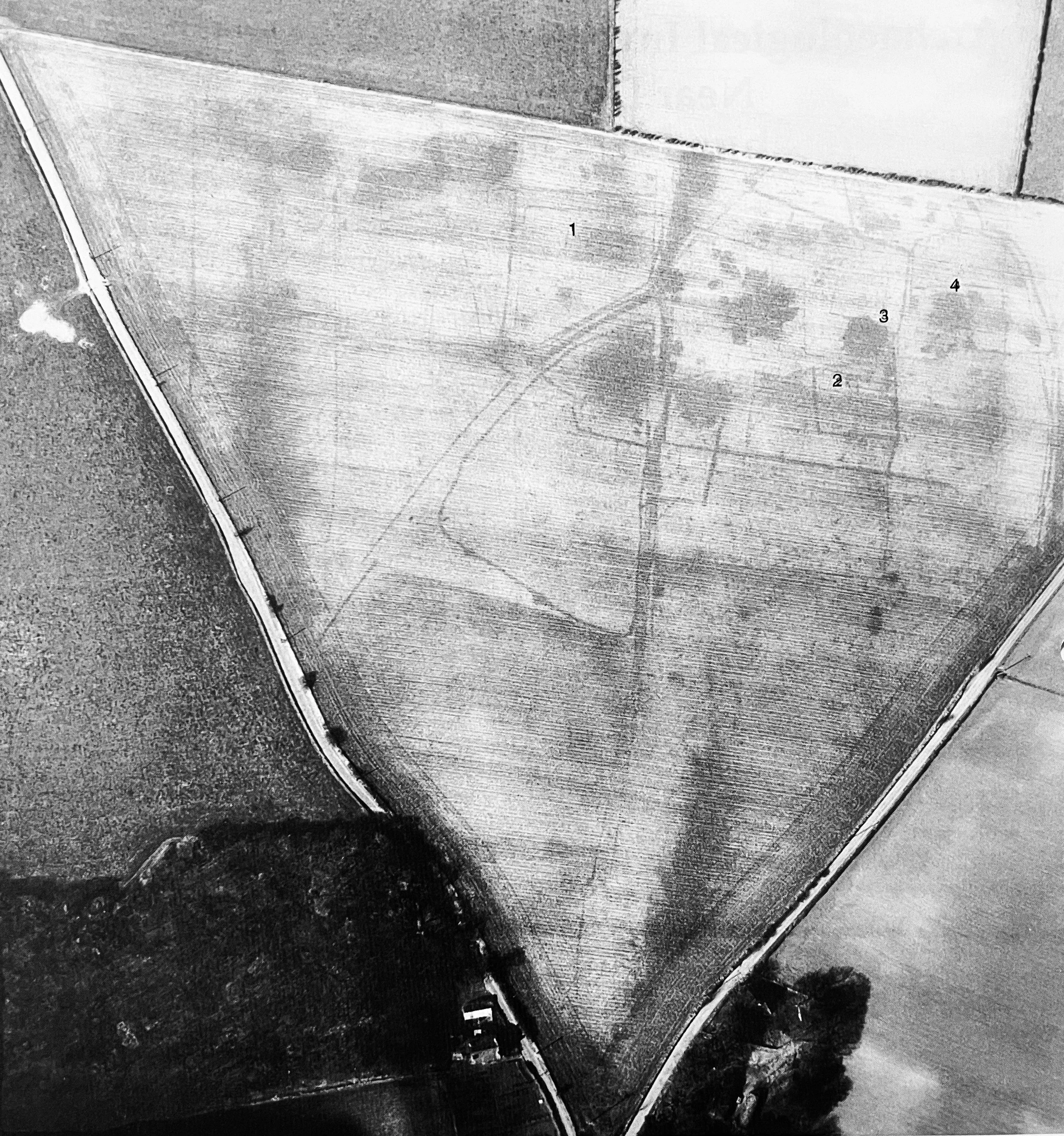 Plate I ; Roman settlement immediately north of Maydensole Farm visible as air photographic features. The modern lane forming the eastern field boundary marks the alignment of the former Roman road (source: NMR908/202 dated 2.3.76). Numbers I and 2 mark the rectangular enclosures, number 3 and 4 mark the positions of the large anomalous foatures identified for investigation.
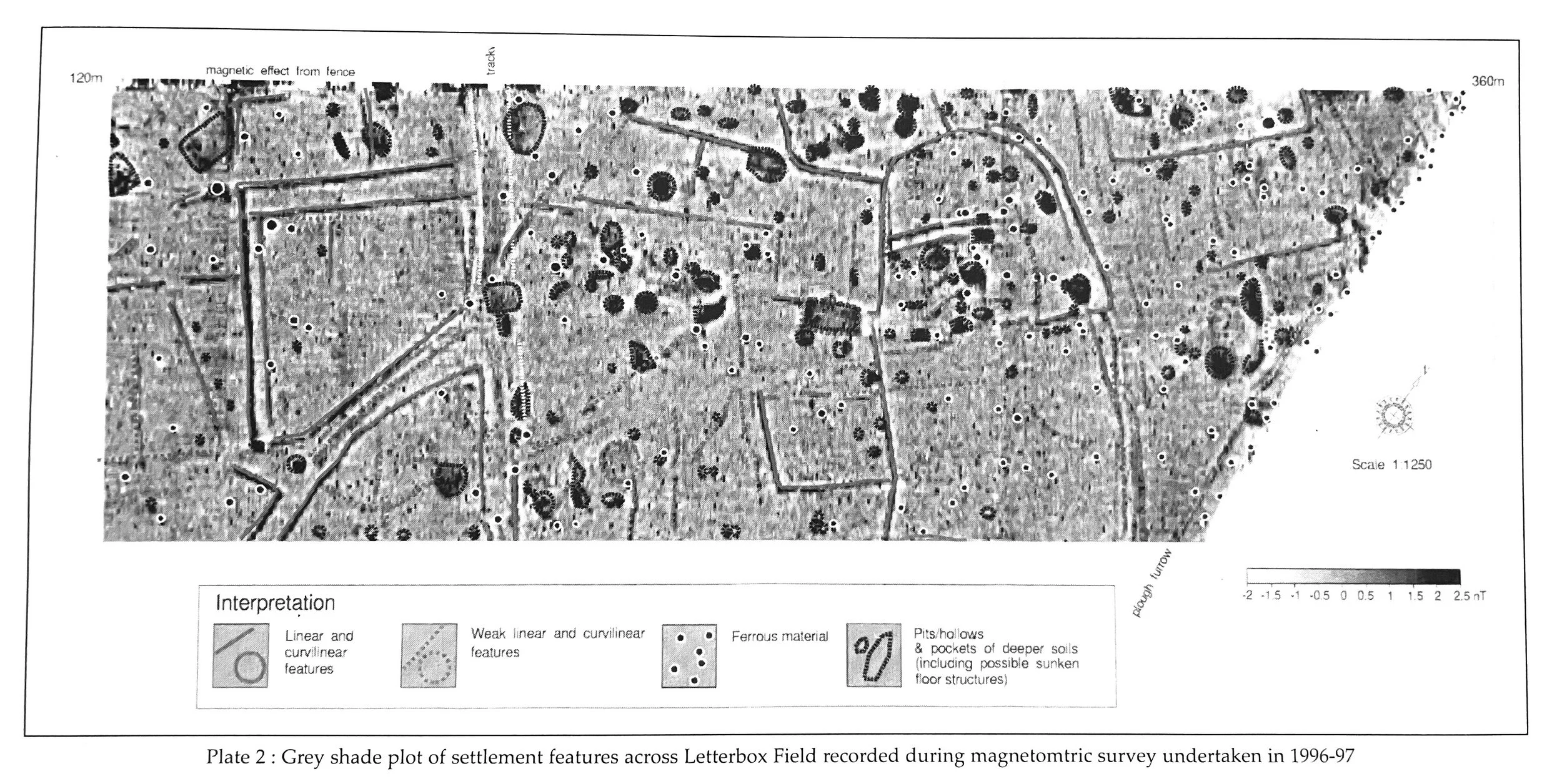 Plate 2: Grey shade plot of settlement features across Letterbox Field recorded during magnetometric survey undertaken in 1996-97
a result of differential growth in the crop across Cottage Field, abutting the eastern side of Roman Road. Newington also recorded the presence of a similar pattern of features across Letterbox field on the western side of the lane, and noted the frequent finding of Roman coins across Cottage Field.
Plate 2: Grey shade plot of settlement features across Letterbox Field recorded during magnetometric survey undertaken in 1996-97
a result of differential growth in the crop across Cottage Field, abutting the eastern side of Roman Road. Newington also recorded the presence of a similar pattern of features across Letterbox field on the western side of the lane, and noted the frequent finding of Roman coins across Cottage Field.
An apparently more significant discovery was made in August 1949 by M. P. Dare, who reported and published the finding of an inscribed Roman domestic portable altar from a point along the line of the former Roman road just south of Maydensole Farm (Dare 1949). Subsequently, a detailed study of the find concluded that although the altar was genuine the inscription was modern (Wright 1951; Anon. 1954). To this day, the reasons for this archaeological hoax remain a mystery.
Following these earlier d1scovenes, archaeological au photographic survey (carried out during 1976-77) revealed for the first time a substantial part of the layout of the settlement, confirming in part the observations made by Newington some 65 years previously (Plate 1). These photographs show that the settlement consists of a number of components: a principle central track or hollow way, other subsidiary track ways, a series of rectangular enclosures, some sub-divided, and ditch alignments probably forming part of the outlaying field system. On the west, the overall pattern of the track ways and enclosures indicates a direct and presumably contemporary relationship between the two, whilst to the east, the ditch alignments define a system of small rectangular fields, abutting and related to another major track way. The track ways clearly converge on Maydensole following alignments to the north-west and north-east.
In contrast, the field system appears to be cut by the former alignment of the Roman road, indicating either that the fields formed part of a Late Iron Age/ early Roman phase of the settlement or that the road was laid out late in the Roman period.
The discoveries recorded by Newington in 1911 indicated that the settlement was occupied during the early Roman period. Over the past twenty years, a substantial corpus of finds has been recovered from the general area of the fields surrounding Maydensole Farm as a result of systematic and continuing amateur metal detecting. These finds have comprised a few Late Iron Age coins and a large number of Roman coins, as well as Roman dress accessories and other artefacts including lead weights, a possible lead seal and quernstone fragments. Overall, the pattern of coin loss, with the bulk of the Roman coins dating to the late 3rd to mid 4th centuries AD, is typical for a Roman period rural settlement (Esmonde Cleary 1997, 453).
Field and Magnetometric Survey 1996-1997
Following cataloguing of this assemblage of metal detected finds, a programme of fieldwork began in August 1996 with a gridded surface field survey. Analysis of the finds recovered, which copsisted largely of pottery, has indicated that the main period of settlement occurred between the 1st to 2nd century AD. The date range of the bulk of the pottery recovered contrasts with the quantity and date range of the coin evidence previously recorded, althqugh there was a significant amount of pottery recovered to suggest clearly continuity of settlement into the late Roman period. The gridded field survey was Rectangular building, showing position of oven (top, centre) and nmt wall foundations.
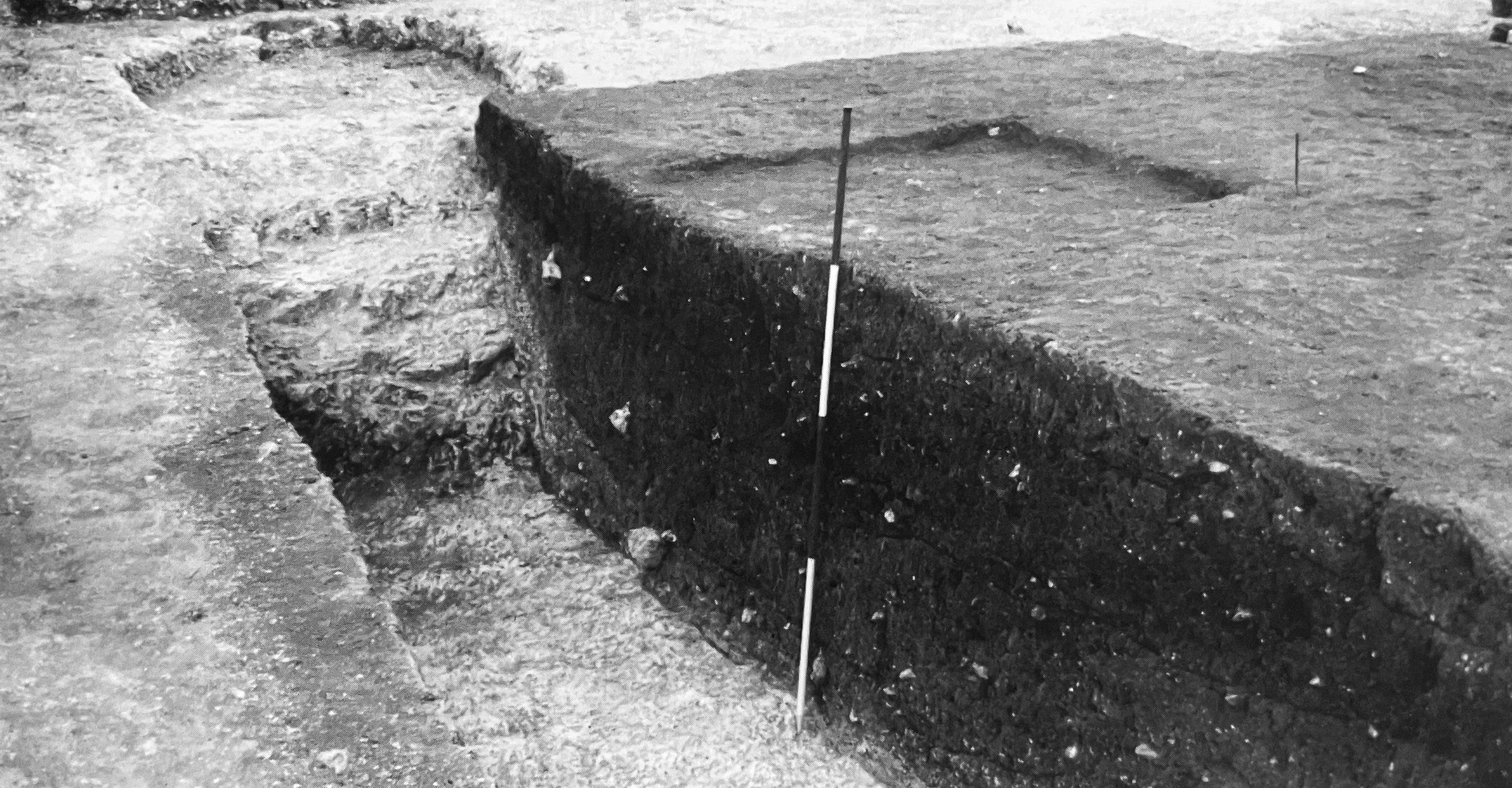 Plate 3: Top Field 1997: Rectangular building, showing position of oven (top, centre) and flint wall foundations.
complimented by a magnetometric evaluation, undertaken in September 1996 and again in September 1997 across 4ha of Letterbox Field O ohnson 1996; 1997). This aimed to enhanced the detail visible on the air photographs and provide further information on the internal morphology and character of the settlement. A complex pattern of small sub-divided rectangular enclosures was revealed, some containing large anomalous features which may possibly be quarries, whilst the presence of possible hearths indicates that some may contain buildings or industrial features (Plate 2).
Plate 3: Top Field 1997: Rectangular building, showing position of oven (top, centre) and flint wall foundations.
complimented by a magnetometric evaluation, undertaken in September 1996 and again in September 1997 across 4ha of Letterbox Field O ohnson 1996; 1997). This aimed to enhanced the detail visible on the air photographs and provide further information on the internal morphology and character of the settlement. A complex pattern of small sub-divided rectangular enclosures was revealed, some containing large anomalous features which may possibly be quarries, whilst the presence of possible hearths indicates that some may contain buildings or industrial features (Plate 2).
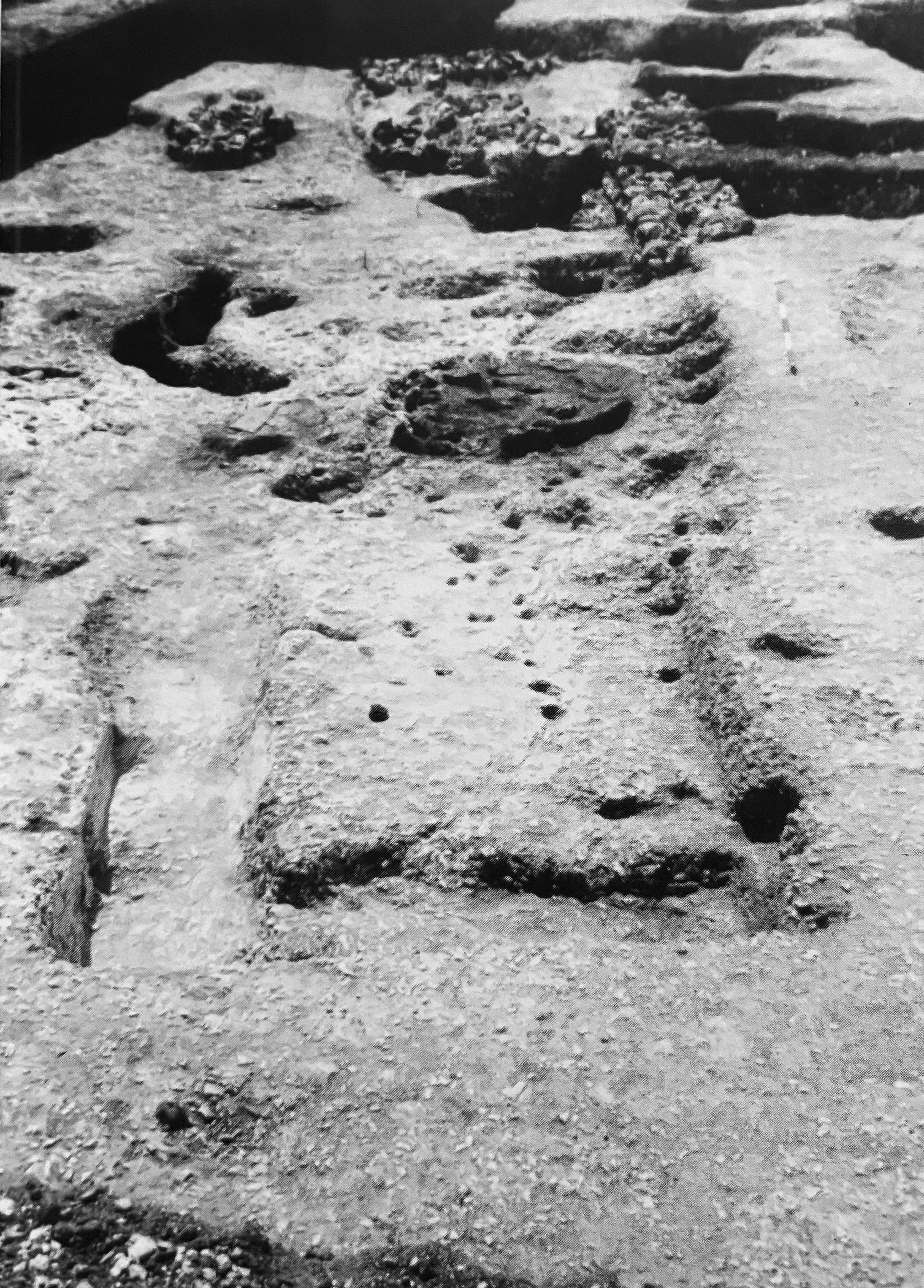 Plate 4: Letterbox Field 1998: Section across quarry feature showing southern stepped edge
and fills. The associated sunken-featured building is visible in the background.
Plate 4: Letterbox Field 1998: Section across quarry feature showing southern stepped edge
and fills. The associated sunken-featured building is visible in the background.
Excavations 1997-1999
Evaluation excavations were undertaken between May and September 1997 along the southern edge of Top Field, adjacent to Letterbox Field. The evaluation comprised a 150m long machine cut trench which revealed the principal south-east to north-west aligned central hollow way previously referred to, which was found to have a width and depth of 15m and 2m respectively. In addition, a number of lesser track ways, intersecting and re-cut boundary ditches defining field systems and enclosures and a number of small quarry pits were recorded, many of the features dating to the 1st to 2nd centuries AD.
The investigations also revealed the greater part of a building, occupied through to the late 4th century AD, with substantial flint wall foundations, internal partitions of different periods and an oven. Infant burials were also found, interred tight up against the wall foundations (Plate 3). To the north of the building, a deep oval pit of much earlier date contained possible ritual deposits, the fills incorporating the carefully deposited remains of a chicken, directly overlying a separate deposit containing the skull of a large dog. The excavations also produced a significant assemblage of pottery, including one large early-mid 1st century AD group in association with a Late Iron Age coin of Sego, circn 1BC-AD10. The fills of some of the ditch and pit features, as well as some of the later structural features of the building, contained late Roman pottery and coins, showing the settlement was occupied through to the latter decades of the 4th century AD.
Further open area excavations were undertaken between August 1998 and February 1999 across a central section of Letterbox Field within the area previously subject to magmetometric survey. The primary aim was to examine a representative area of the settlement to obtain information on its chronological development, status and function. The excavation revealed the greater part of the layout of one of the enclosures and the relationship to adjoining fl'enclosures, together with short lengths of ditches of different character and date. Investigation of the large anomalous features on the magmetometric survey revealed that these probably represented deep linear quarries located at the corners of the enclosures. Abutting the southern edge of one of the features the complete plan of a sunken featured building was recorded (Plate 4).
The final infilling of the quarry features consisted of a dark loam soil containing quantities of ash and a considerable quantity of artefacts and coins including some dating to the late 4th century AD. The latest features recorded comprised a series of substantial flint packed postholes cutting the final fills of the quarry features, probably representing part of a large late or post-Roman timber building.
Post excavation study and analysis of the results of the various phases of field investigations is now well advanced with the results for work undertaken to 1998 largely complete. Publication of the final results is planned for 2001 / 2. Further episodes of field investigation are also being considered.
Richard Cross and Tony Redding
February 2000
e-mail: trspr@trspr.co.uk
References
Roman altar from Napchester, near Dover Archaeologia
Ca11tia11a 68, 214.
Dare, M.P. 1949 An inscribed Roman altar discovered
at Napchester near Dover Archaeologia CanHana
62, 94-8.
Esmonde Cleary, A.S. 1997 Roman Britain in 1996 :
England Britannia 28, 414-453.
Johnson, A.E. 1996 Letterbox Field, Maydensole,
Whitfield, Dover : gradiometer survey September 1996
Noke, Oxford Archaeotechnics Ltd, Survey Reference
0970996/MAK/ ACR.
Johnson, A.E. 1997 Letterbox Field, Maydensole,
Whitfield, Dover : additional gradiometer survey November
1997 Noke, Oxford Archaeotechnics Ltd, Survey
Reference 0970996/MAK/ ACR.
Payne, G. 1911 Researches and discoveries in Kent
1908-1910 Archaeologia Cantiana 29, lxxvi-lxxxv.
Wright, R.P. 1951 Jn[ of Roman Studies 41, 145.